

By Jeremy Ross, PhD
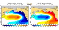
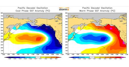
Long-term variations in ocean circulations produce pronounced patterns of sea surface temperature (SST) anomalies that directly impact weather and climate. The most influential long-term oceanic cycle is the Pacific Decadal Oscillation (PDO), a large-scale phenomenon in the North Pacific that produces inter-decadal oscillations of cool and warm SST anomalies, with each phase typically lasting 20 to 30 years. During the cool (negative) phase of the PDO, a large horseshoe-shaped area of cooler than average SST extends from the central equatorial tropics northeastward to the Mexican and U.S. coastlines, then northward along the Canadian and Alaskan coastlines. During the warm (positive) phase the pattern is reversed with warm SSTs replacing the cool SSTs. The Atlantic Ocean experiences a similar oscillation known as the Atlantic Multidecadal Oscillation (AMO) which has profound impacts on the number and intensity of Atlantic hurricanes as well as Arctic sea ice extent.
See larger image here.
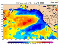
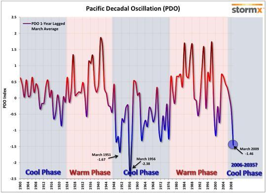
After a period of intense cooling in the 1950s, 1960s, and 1970s, the PDO returned to the positive phase during the late 1970s and remained generally positive through the late 1990s. Since 1999, a transition into the cool phase has been underway, and during 2008 the transition was completed as recent observations of the coastal waters have been among the coolest in the past 109 years.
See larger image here.
Long-term variations in ocean circulations produce pronounced patterns of sea surface temperature (SST) anomalies that directly impact weather and climate. The most influential long-term oceanic cycle is the Pacific Decadal Oscillation (PDO), a large-scale phenomenon in the North Pacific that produces inter-decadal oscillations of cool and warm SST anomalies, with each phase typically lasting 20 to 30 years. During the cool (negative) phase of the PDO, a large horseshoe-shaped area of cooler than average SST extends from the central equatorial tropics northeastward to the Mexican and U.S. coastlines, then northward along the Canadian and Alaskan coastlines. During the warm (positive) phase the pattern is reversed with warm SSTs replacing the cool SSTs. The Atlantic Ocean experiences a similar oscillation known as the Atlantic Multidecadal Oscillation (AMO) which has profound impacts on the number and intensity of Atlantic hurricanes as well as Arctic sea ice extent.
After a period of intense cooling in the 1950s, 1960s, and 1970s, the PDO returned to the positive phase during the late 1970s and remained generally positive through the late 1990s. Since 1999, a transition into the cool phase has been underway, and during 2008 the transition was completed as recent observations of the coastal waters have been among the coolest in the past 109 years.
The average PDO index from April 2008 to March 2009 was -1.46, the third lowest yearly averaged March value since 1900, trailing only March of 1956 and 1951. For the next two or three decades, North Pacific SST anomalies will favor the negative phase, and will likely produce exceptional climate patterns and weather events that have not been observed in more than three decades.

See larger image here.
The strongly negative PDO was influential in shaping North American climate during the past year. In 2008, Anchorage, Alaska, recorded only 2 days above 70 degrees F, the least number of days to exceed 70 since records began in 1917. The PDO strongly influenced the winter of 2008/2009 with dry conditions and warmth in the south central U.S. and snowy and colder than average temperatures in the Northern Plains. Although the PDO will continue to be the dominant climate driver for the remainder of 2009, its impacts will subside during the summer when the atmospheric flow weakens and climate is more strongly affected by local influences such as land conditions and proximity to water bodies.
Read more here.