


By Joseph DAleo, CCM Co-Chief Meteorologist Weatherbell Analytics, LLC
Climate alarmists have consistently said we could look forward to more frequent and stronger hurricanes, thanks to climate change. Our climate is always changing but the changes are driven by natural cycles. Ocean temperature events like El Nino and La Nina and longer-term cycles like the Pacific Decadal Oscillation (PDO) and Atlantic Multidecadal Oscillation (AMO) determine where hurricanes are most likely to occur and how strong and damaging they may become.
In 2023, in the Pacific, a strong El Nino developed in the eastern Pacific after a 3 year stubborn La Nina, favoring more and stronger storms in the Pacific. Meanwhile, a record warm tropical and subtropical Atlantic created a conducive environment for the continuation of overall above-normal Atlantic hurricane seasons. However, the El Nino played a role in keeping all but one Atlantic storm (Idalia) out at sea.
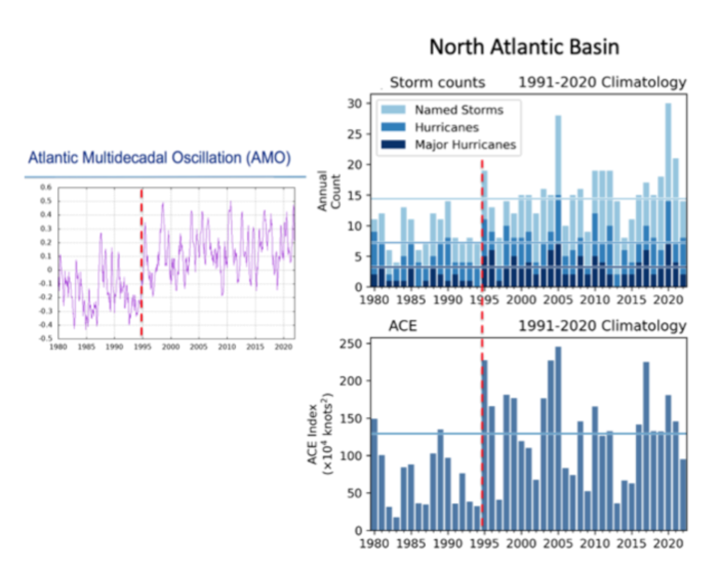
A great example of the roles of the oceans has been observed the last half century. When the Atlantic was cold in the 1960s to early 1990s (negative AMO or Atlantic Multidecadal Oscillation) Atlantic storms were much less frequent and landfalls mostly limited to the Gulf Coast. When the Atlantic swung into its multi-decadal warm mode in the late 1990s, the activity in the Atlantic more than doubled on average.

Enlarged
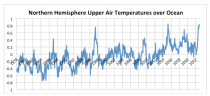
The Atlantic temperatures spiked in 2023 as the planet readjusted after 3 years of La Nina. Some scientists believe that Hunga Tonga-Hunga Ha’apai erupted in January 2022, shot 146 metric megatons of water into the stratosphere potentially contributing to atmospheric warming according to a new study published in Nature Climate Change.
THE PACIFIC OCEAN CYCLE - EL NINOS VS LA NINAS
Activity tends to be higher in the Atlantic Basin when the Atlantic is warm and when La Ninas and the negative (cold) Pacific Decadal Oscillation (PDO) are in place in the tropical Pacific. The cold eastern Pacific waters in La Ninas reduce hurricane development in that region but do not affect Atlantic activity.
When El Ninos and the warmer Pacific Decadal Oscillation (PDO) are present, hurricanes become more likely there but the east Pacific storms produces shear in the upper atmosphere in the Atlantic that disrupts developing storms.
Gray 1984 found that of the 54 major hurricanes striking the U.S. coast between 1900 and 1983, only 4 occurred in 16 El Nino years in contrast to 50 making landfall during the 68 non El Nino years. This is a rate of 0.25 major hurricanes during El Nino and 0.74 per year in non-El Nino years, almost a 3 to 1 ratio. Tartaglione etal in 2002 showed there was a 71% greater chance of an impact on the east coast in La Nina years
When a three-year La Nina faded this spring and summer, expectations were that the warm water would generate super storms in the Pacific Basin.
Indeed Hurricane Hillary on late August became the first tropical cyclone to make landfall in California in over eight decades. Death Valley, known for being the hottest place on earth, received a year’s worth of rain in 24 hours, had its wettest day in history. Otis followed in late October intensifying a full five categories, from a tropical storm to a Category 5 hurricane - the highest level - in less than 24 hours before landfall on Mexico.
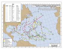
For the Atlantic, record warm ocean temperatures August to October resulted in 20 named storms, 4th highest for the U.S. but thanks to El Nino, only Hurricane Idalia made landfall with max winds of 110 kt the strongest hurricane to make landfall in the Big Bend region of Florida since 1896.
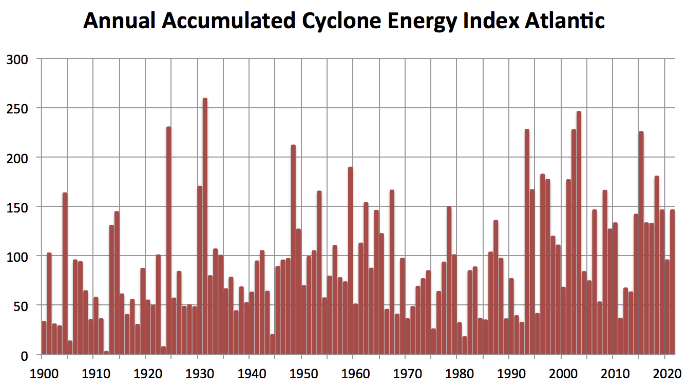
The Accumulated Cyclone Energy Index, the best measure of the seasons activity shows the active period starting in the middle 1990s with the Atlantic AMO in it’s warm mode.

The late season was characterized by sinking motion and no storm development in the Caribbean during September, often a busy time of year. Without tropical activity, drought conditions prevailed in the western Gulf States.
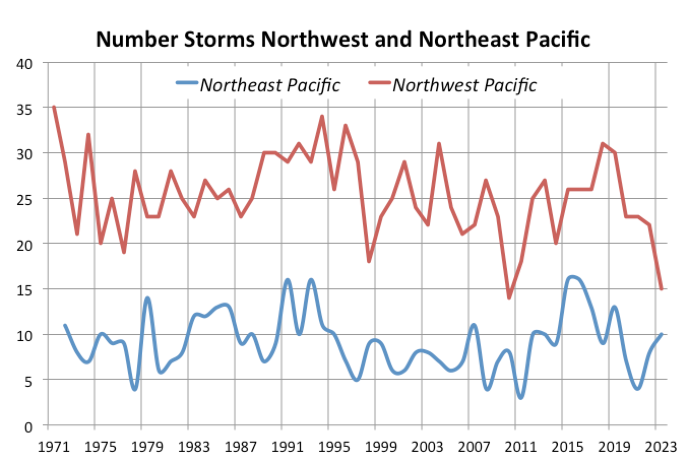
The El Nino was biased to the eastern Pacific during the early to mid tropical season, which kept the overall numbers down in the western Pacific region.
Enlarged
It should be noted that the 2023 season was characterized by unusual rapid intensification of some of the storms that impacted land as well as unusual landfall locations. Dr. Phil Klotzbach, one of the many star students of the late great Dr. Bill Gray continues his fine work at CSU. See his excellent detailed review of this unusual season here.
See more detail on hurricane seasons here