


Dr. Anthony Lupo
As we enter summer, the narrative is that the January to May period nationally has been the warmest on record, approximately 5.0 degrees Fahrenheit above the long term average [1]. This came on the heels of an incredible month of March which was 8.6 degrees Fahrenheit above the long term average and the warmest since 1895 [1]. The days were warm and spring came early. But we also heard about how this was not really a good thing, that this March was somehow unnatural, like “the weather equivalent of baseball player on steroids” [2]. The implication is that humans are the driving force behind the warmth.
In the Missouri region, March was about 15.2 degrees above the 1981-2010 normal. The year-to-date is running about 7.4 degrees Fahrenheit above the same benchmark for January to May. In fact, this year-to-date is running some 2.8 degrees ahead of the next closest January to May which was way back in 1921! March itself shattered the previous record for that month beating out March 1946, the previous standard, by a whopping 3.7 degrees! How unprecedented is such an occurrence?
While they don’t happen often, monthly temperature anomalies of 10 - 15 degrees above normal do happen here in the middle of the continent where weather extremes are typically greater in magnitude. Remarkable cold anomalies have occurred as well historically, for example, our region experienced temperatures that were 16.0, 15.8, and 15.2 degrees below the normal during January 1977, March 1960, and December 1983, respectively.
Then, was March 2012 really a new standard among warm anomalies? In our region, it was not. One can go all the way back to 1889 and find that December was an incredible 16.8 degrees above the latest climate normal for 1981-2010 (which was the same as 1891-1920 for December). During that month, only seven nights experienced temperatures below freezing and only two below 20 degrees. No day time highs were colder than freezing and only the last two days of the month averaged below freezing. A check of daily weather maps [3], such as they were in those days, reveals that the warmth was also widespread in a manner similar to that of March 2012. During that Holiday season, Jack Frost took a lot of time off from nipping at noses!
The year 1889 is not a period one typically associates with human induced global warming. Also, warm (or cold) anomalies such as this do not typically occur in isolation. One can then study the periods leading up to and following such an event, and a comparison of March 2012 with the December 1889 period can be done.
We should note that both months occurred during a year that could be classified as weakly La Nina (although the jury may be out on 2011 – 2012 whether it meets the exact criterion) [4]. The temperatures were cooler than normal leading up to December 1889. In the following nine months, however, six were warmer than normal, four including the two immediately following were well above the normal. March 2012 was preceded by three straight mild winter months, and was followed by a normal April. May returned to warmer conditions again, and the first half of June has been only marginally warmer than normal in this region.
Examining the precipitation leading up to each month including that month, the 1889 period was drier than normal as the precipitation was only about 75% of normal regionally. The March 2012 period was wetter than normal, but given the warm temperatures, there was likely more evaporation than normal. Dew point records are not available for the earlier period, and are not yet entirely available for the December 2011 - March 2012 period. It can safely be assumed that both periods were a bit dry, which would help create the favorable conditions for warmer temperatures in each month.
Further a comparative study of the atmosphere for these two periods is currently underway, and it can be seen from looking at the monthly composite upper air maps for both periods that the coldest air was bottled up to the north in the Arctic, while the eastern two-thirds of the nation were under a fairly strong ridging event (Fig. 1). This means that both periods experienced more sunshine during the month, and overall similar mechanisms may have been at work in producing December 1889 and March 2012, and both may have been the result of a similar confluence of atmospheric and oceanic forcing over North America.
And while North America has been warm from late 2011 and into 2012, similar circumstances are not happening globally[1]. Will such a warm event occur again soon over North America? Given the historical record, it is not very likely. But the bottom line is that the occurrence of these events has a readily explainable cause that does not invoke excess carbon dioxide.
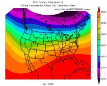
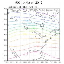
Figure 1. The 500 hPa maps for December 1889 (top) and March 2012 (bottom). The map for December 1889 was derived with much less data, and uses a slightly different map projection.
References:
[1] State of the Climate National Overview.
[2] Borenstein, S., 2012: Start of 2012, March shatter US heat records. For the Associated Press, for example see:
[3] Daily Weather Maps.
[4] Center for Ocean and Atmospheric Prediction Studies.