


Climate Highlights - April
The April average temperature for the contiguous U.S. was 49.7F, which was 1.4F below the 20th century average. April 2013 ranked as the 23rd coolest such month on record and marked the coolest April since 1997 when the monthly average temperature for the contiguous U.S. was 48.0F.
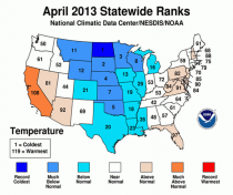
The central U.S. was much cooler than average during April. North Dakota had its coldest April on record with a statewide average temperature of 31.0F, 9.9F below average. Six additional states - South Dakota,Nebraska, Kansas, Oklahoma, Minnesota, and Wisconsin - each had a top ten cold April. Below-average temperatures were also present for the Northern and Central Rockies, the Southern Plains, and the Mississippi River Valley.
Near and above-average temperatures were present along the U.S. East Coast and in parts of the West.California had its 12th warmest April on record with a statewide temperature 3.7F above average.
The April average precipitation for the contiguous U.S. was 2.90 inches, 0.47 inch above average, and tied with 1953 as the 19th wettest April on record.
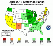
The Northwest, Midwest, and the Southeast were wetter than average. Iowa and Michigan both had their wettest April on record. The Iowa statewide average precipitation total of 6.71 inches was 3.76 inches above average; the Michigan precipitation total of 5.97 inches was 3.29 inches above average. Additionally,Tennessee, Illinois, Indiana, and Wisconsin each had one of the ten wettest Aprils on record.
The wet conditions in the central U.S. resulted in several rivers in Illinois, Iowa, and Michigan reaching record high levels, with widespread flooding observed. The Mississippi River at St. Louis also reached flood stage after dropping to near-record low levels at the beginning of the year.
Below-average precipitation was observed in the Southwest and Northwest. New Mexico had its 12th driest April, while Connecticut and Rhode Island had their sixth and 11th driest April, respectively.
Alaska was much cooler than average during April, with a statewide average temperature 5.8F below the 1971-2000 average. This was the 7th coldest April in the 96-year period of record for the state, and the coldest April since 1985. The average temperature in Fairbanks was 14.5F below normal and the coldest April on record for the city.
According to the April 30 U.S. Drought Monitor report, 46.9 percent of the contiguous U.S. was experiencing moderate-to-exceptional drought, smaller than the 51.9 percent at the beginning of the month. Drought conditions continued to improve across the Southeast, Midwest, and along the northern and eastern periphery of the core drought areas of the Great Plains. Drought conditions worsened for parts of the Southwest, and drought continued for much of the Great Plains and Mountain West.
Several storms impacted the U.S. bringing record-breaking, late-season snowfall to central United States. According to data from the Rutgers Global Snow Lab, the April snow cover extent for the contiguous U.S. was approximately 480,000 square miles, 209,000 square miles above the 1981-2010 average and the 5thlargest April snow cover extent in the 47-year period of record. However, dismal snowpack continued in parts of the West, with only 18 percent of normal snowpack reported in the Sierra Nevada Mountains.
On a local basis, over three times as many record cold highs and lows occurred than record warm highs and lows. Approximately 3,430 record low temperatures and about 4,050 record cool daily high temperatureswere tied or broken. In comparison, approximately 690 record warm daily high temperature records and 1,570 record warm daily low temperatures were tied or broken.
March/April was the coldest since 1996 and 33rd coldest out of 119 years.
Climate Highlights - year-to-date (January - April)
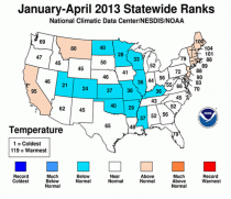
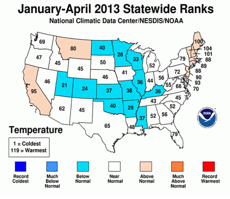
The average temperature for the contiguous U.S. for the year-to-date period was 39.3°F, which was near the long-term average. Near to below-average temperatures were present from the Rockies, through the Plains and into the Ohio Valley. Near to above-average temperatures were observed in the West and the Northeast.
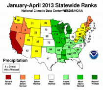
The nationally-averaged precipitation total for the year-to-date period was 8.94 inches, 0.13 inch below average.
Wetter-than-average conditions stretched from the Great Lakes, along the Mississippi River Valley, and into the Southeast. Michigan and Wisconsin each had their wettest January-April, with precipitation totals 5.26 inches and 3.62 inches above average, respectively. Minnesota, Iowa, Missouri, and Illinois also had a top ten wettest year-to-date period.
Much of the western and northeastern U.S. was drier than average during January-April. In the West,California had its driest year-to-date with a statewide precipitation total of 3.59 inches, 9.49 inches below average. Oregon, Nevada, and Idaho each had one of their ten driest year-to-date periods. In the Northeast,Connecticut, Maine, New Hampshire, and Vermont also had a top ten dry January-April.
The year-to-date USCEI was near-average. Despite the near-average USCEI, the extremes in 1-day precipitation totals and the component that examines the spatial extent of drought were both much above average.