By Joseph D’Aleo, CCM
Recently we reported on a study funded by the Pew Charitable Trusts and conducted by the Vermont Public Research and Education Fund purports to show increased extreme precipitation events-rain and snow-in the United States over the last 59 years, perhaps linked to global warming. The first half of the period studied was the last cold phase of the Pacific Decadal Oscillation, an ocean current pattern that strongly affects storm tracks and thus precipitation over North America. Half way through the VPIRG study period the PDO flipped to its warm phase. The VPIRG carefully picked a period where it could hardly have avoided getting the higher precipitation frequency that it wanted for maximum shock effect.
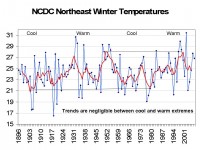
A new study by the University of New Hampshire reported by the AP that looks at temperatures and snowfall in the northeast. It conveniently starts in 1965 near the bottom of the last cool period and ends in 2005 near the peak of the latest warm period. Their study of weather station data from across the Northeast from 1965 through 2005 found temperatures from December through March increased by 2.5 degrees over the four decades.
When you look at the National Climate Data Center data for the northeast region for the entire record since 1895, you see cycles of warming and cooling but little in the way of any net change from warmest 5 year mean peak (1950 for this region) to next warmest peak (2000) or coldest year (1903) to next coldest year (1980).

See larger image here.
Read in this analysis more on the temperature issue and why although their analysis of snowfall changes are likely correct, they have can be easily explained by changes in storm tracks due to changes in the Pacific.
UPDATE: See this news story today about the very heavy snow season this year in New Hampshire, Latest Storm Brings State Closer to Snow Record.


