


By Joseph D’Aleo, CCM
Starting with post Christmas blizzard, the northeast has had snowstorms weekly. Midwinter snow totals already exceed full season averages by a significant amount. Our friends in the National Weather Service reports so far this season (through January 29th):
Hartford, CT 71.2 inches
Worcester, MA 61.6 inches
Boston, MA 60.3 inches
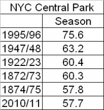
New York City Central Park 56.1 inches
Bridgeport, CT 54.4 inches
In New York City with two more months of winter ahead, the season already ranked 6th place all-time.
A general 10 to 30 inches of snow depth remains on the ground...with the deepest snow depth values across Connecticut.
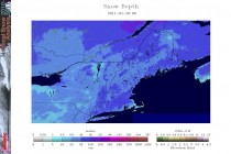
Enlarged here.
3 to 5 inches of snow water equivalent is in the current snowpack across the area. This results in a tremendous amount of weight per square foot.
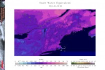
Enlarged here.
There have already been reports of collapsed roofs due to the weight of the snow...and with the threat of yet another significant storm system expected during the middle of this week...now is the time for residents and building owners to take preventative action to safely remove snow from flat roof tops, decks, etc.
Recall the collapse of the Metrodome in Minneapolis earlier this winter captured by a FOX camera.
Between 2 and 4 tenths of liquid equivalent is forecast from late Monday night through Tuesday in the northeast...mostly in the form of snow.
There is the potential for significant (1-2 inches) liquid equivalent from Tuesday night into Wednesday night. This should be mainly in the form of freezing or frozen precipitation across the interior...and a wintry mix to rain across coastal areas. Based on this there is also the potential for minor urban/poor drainage flooding across coastal areas… depending on exactly how much of the precipitation falls as rain.
The storm is the same storm that will bring wintry weather all across the nations from the mountains of the west across the Plains, Ohio Valley and southern Great Lakes. Hard hit places will include the Central Plains northeast to Chicago (areas around the ‘windy city’ could have 20 inches plus - the all-time record for a snowstorm in Chicago is 23.0 inches on January 26-27, 1967, a La Nina in a cold PDO after a prior El Nino like this year). Ice and snow will make for hazardous travel in many areas into the Ohio Valley and parts of the northeast. One benefit will be the help it provides extinguishing the Oklahoma fires. Though it has been a nightmare at times for travellers, businesses, schools and homeowners, ski areas are having a banner year.