While many in government, the universities and media want to focus on the small (mostly very local) influence we have on climates (one of my favorite course when a college professor was Microclimatology where we studied in the field and literature the local factors, natural and man-made). That spurred focus on urbanization in climate data as most stations became increasingly urbanized and warmer at night. However I spent much of my career in 5 major enterprises studying the larger scale natural factors that influence global climate regimes and have been able to explain not only the observed cycles in properly measured temperatures but changes in extremes of weather. I found the most significant drivers included ocean cycles, solar cycles and volcanism. Man’s contributions were primarily local and related to land use changes including as I noted most importantly urbanization.
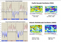
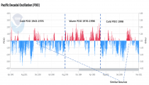
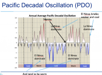
I had the good fortune to meet at an AMS Annual Meeting Jerome Namias, NWS first Director for Weather Bureau’s (now NWS) Long Range Forecasting (started being 5 days) Branch (now CPC or the Climate Prediction Center) who showed ocean warm and cold pools explained the flip to the cold winter of the late 1970s. After the super El Nino of 1982/83 just after the birth of The Weather Channel, as the first Director of Meteorology, we did the first features on the phenomenon. We began seasonal outlooks often consulting with Namias who had moved to Scripps). When CPC found in the late 1980s, that El Nino and La Nina had global implications, first observed by Sir Gilbert Walker more than 60 years before (an idea rejected by scientists at the time), we knew we had another tool to forecast seasonal weather. In the 1990s, ocean fisheries scientists at University of Washington discovered the PDO - a longer term Pacific cycle that helped explains shifts in salmon fish populations on the west coast. It also explained tendencies for strength and frequency of El Nino and La Nina. The warm mode favored longer and stronger El Ninos and the cold more frequent and stronger La Ninas. You can see the cold PDO mode has dominated since the Super Nino of 1997/98,
The behavior mimics the cold PDO from the 1940s to the middle 1970s. Both had a significant El Nino a few decades in (1957/58 and 2015/16).
See the behavior described below.
The Atlantic too has a multidecadal cycle called the Atlantic Multidecadal Oscillation (also first published in the 1990s) which affects high latitude blocking events. It has been in the warm mode and stays there for now.
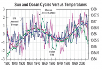
The two oscillations in their positive mode favors global scale warmth, the negative mode cold. See much more here
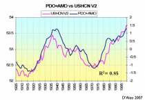
The cycles are now out of phase but when the both are positive, the world is at the warmest level, both negative, cold. See the strong correlation.
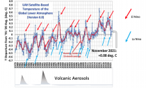
Individual El Ninos always brings a spike in temperatures globally, La Ninas a cooling.
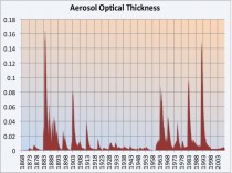
The effect is modulated by major volcanism. See how El Ninos in the 1980s and 1990s were suppressed by the sulfate aerosols thrown into the high atmosphere from the eruptions of Mt. St. Helens, El Chichon and Pinatubo.
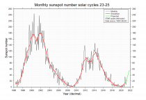
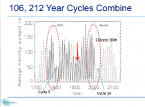
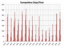
The sun is important - much more than they want you to believe (see). The number of sunspots correlates with other solar factors to drive global temperatures. It is in a century-scale decline period that should, with some delay, enhance a cooling trend. We are coming off the short cycle minima but still are having spotless days.
Solar activity is most similar now to the cold early 1900s or even the early 1800s, the Dalton Minimum, a very cold period aided by the cooling after Mt. Tambora 1815 eruption
Though at the moment the Pacific and solar favor cold developing, volcanism is at the moment not significant and thus not an enhancing factor and the Atlantic Basin is in the warm phase though declining.
That does not mean we won’t get extreme cold at times in places this year as they found in both polar regions (a record cold winter at the South Pole (since record began in 1957), a brutal November in Alaska and the very early freeze off the Russia Arctic coast trapping ships and in much of the southern hemisphere in their entire winter and spring. There is in most years where the ENSO state is modest to weak have variability in season as waves propagate through the topics and affect the locations of the troughs and ridges in the jet stream that influence where the cold and warm, and storms travel. Such a wave turned off the cold here in the US in December for a time but it will soon move to locations that open up the floodgates from the arctic.
We are especially vigilant and concerned at Weatherbell as the energy grid operators and suppliers are warning that an extended period of strong cold would mean rolling blackouts and energy supply issues as we saw last winter in Texas when over 100 died as temperatures dropped to well below zero with the power out. That is something the factors at play have been suggesting would happen this winter. After that upcoming global weather pattern reorganization, we see the arctic cold beginning later this upcoming week.
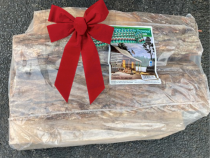
Below is a Christmas present you may consider for family and friends that have wood stoves or fireplaces, they are not expecting to use. 5 packages could keep the family warm for several days. Local firewood companies still have dry firewood. It is always best to have the chimney checked out - a small investment that could save problems.
Stay warm and safe… and open minded.


_thumb.png)
