Watts Up With That
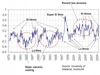
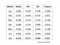
Hot off the press from Dr. Roy Spencer. After being essentially zero last month, we have a jump to .410C in July. This was not unexpected, as a El Nino has been developing.

See larger image here.
August 5th, 2009

See larger image here.
July 2009 experienced a large jump in global average tropospheric temperatures, from +0.00 deg. C in June to +0.41 deg. C in July, with the tropics and southern hemisphere showing the greatest warming.
NOTE: For those who are monitoring the daily progress of global-average temperatures here, we will be switching from NOAA-15 to Aqua AMSU in the next few weeks, which will provide more accurate tracking on a daily basis. We will be including both our lower troposphere (LT) and mid-tropospheric (MT) pre-processing of the data.
Lucia at the Blackboard has an analysis of RSS, which came in higher this month also, at 0.392C. See post and comments on WUWT here.
Icecap Note: Given NOAAs warm bias for NH land and now global oceans, expect them to have July 2009 rank as the warmest on record, despite much anecdotal evidence to the contrary here in the US and elsewhere. The South Pole had a record cold July and some very cold weather was experienced in Argentina and Brazil and New Zealand, so the very dramatic southern hemispheric warming is a bit of a puzzle and to a large degree is driving the jump globally. The tropics warming was influenced by the developing El Nino as Anthony notes which invariably leads to a global warming. The shorter El Ninos in the cold PDO suggest though they may claim victory and that the skeptic cooling is over, I suspect as La Nina returns in 2010, and the sun is slow to come out of its ultra long slumber, they will be forced to eat their words once again.


