


By Joseh D’Aleo, CCM, WeatherBell
SEE ALSO today’s post April 30 Blizzard warning in North Dakota and the coldest April in 36 years in Pacific Northwest. Alarmists said as late as 2006 “Springtime melt now starts some 20 days earlier than a half-century ago, which is “pretty unequivocally” seen as a signature of climate change.” Snowmelt has been at least 30 days LATER than normal this year and it is typical of the last 4 cold springs there. Pretty unequivocally COOLING is taking place but I am sure they will figure out a way to claim that this was expected or consistent with their models.
--------------------------
Epic severe weather week
We talked about this would be a season of major floods and severe weather in our first posts on WeatherBell and Icecap in early March. Last week we warned the middle of this week would see another outbreak like the one in Mid April. And earlier this week we predicted the count would top 200 tornadoes before it was all said and done.
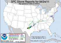
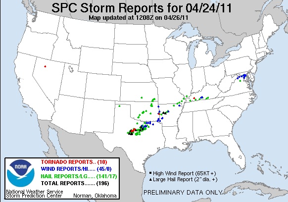
It started Sunday in the southern Plains with 10 tornadoes and 196 severe storms reports.
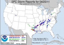
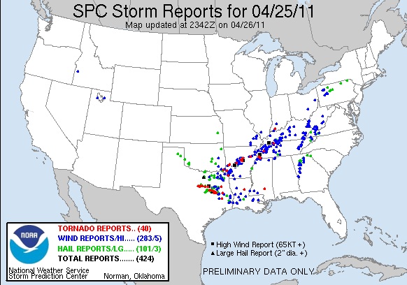
Monday it ramped up with 40 tornado and 424 severe weather reports.
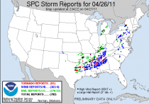
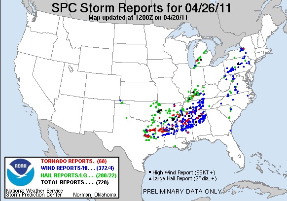
Tuesday action shifted slightly east and increased further with 61 tornadoes among 702 severe weather reports.
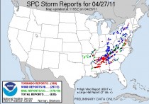
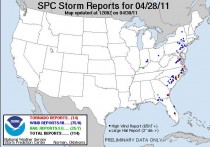
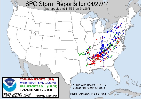
For yesterday, the preliminary count is an amazing 160 tornado tornadoes and 635 severe weather reports. The Gulf States were especially hard hit but with tornadoes up to Virginia and even New York State.
The preliminary total for the 4 days came to 278 tornado reports and an amazing 1970 reports of severe weather.
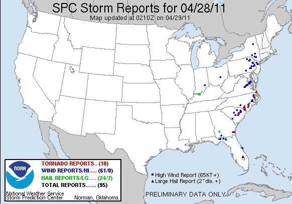
Thursday was the last day if this onslaught. Friday saw additional tornadoes near the east coast before the storms moved offshore. Preliminary reports had 14 tornado and 114 severe weather reports, bringing the total for the week to 282 tornado and 2084 severe weather reports.
The actual number of tornadoes will be reduced as with the longer track storms like we often see in this kind of situation, the same tornado can be reported multiple times. It will take them awhile to sort this out. Especially given the same people will be busy with the next severe weather. It looks like it will be mostly associated with squall lines ahead of more rapidly moving cold fronts in this new pattern with increased blocking at least for the next week or so.
Clearly though this week’s onslaught will rank among the most significant outbreaks in history Sadly the death toll this morning stood at over 337 and climbing.
The devastation from the severe weather mentioned is made worse with the massive flooding occurring in the nations midsection and in the interior parts of the northeast. The cooling and stabilizing air mass off the still cold Atlantic usually knocks the legs out from the thunderstorms that move east and even diminish the rains so eastern and southern New England will probably get off relatively easy.
One last point. the great Stanley Changnon, formerly director of the Illinois Water Survey had done a study probably in the 1990s that I reported on about how although the media attention was mainly on the feared El Ninos, that La Ninas were far more dangerous and costly with more cold and heavy winter snows that paralyze economies and transportation, more spring flooding and deadly and damaging severe weather outbreaks and more landfalling hurricanes than El Nino. The last few years and especially this year is an illustration of this. The severe weather season is not over and then we have the hurricane season which both JB and I think will be more impactful.
See posts on Weatherbell.com.
No doubt there will be some suggesting the severe weather and floods is due to global warming but as we discussed in numerous posts on Weatherbell (like this from last week advertizing this outbreak), it was a combination of the most spring snowcover across the hemisphere in a quarter century, unusual cold across the north (Billings MT 118 straight days with lows below 40, a new record and soil temperatures in Iowa and other parts of th Upper Midwest still mostly in the 40s, which is why corn planting is well behind normal) which increases the contrast and enhances the jet stream which energizes the storms that ride along it, and finally warm dry air flowing out of the droughty southern plains into mid levels making the air convectively unstable. These classic severe weather iongredients were common in the last cold PDO when the La Ninas occurred (1965 Palm Sunday outbreak, the 1967 Belvidere and St Louis outbreaks and then the 1974 Superoutbreak). The last time we had these active springs was the last time the globe was COOLING - from the late 1940s to the mid 1970s. Don’t let them tell you its warming.
SEE THIS EXCELLENT APPINSYS ‘TORNADO LIES’ POST that explains why climate hucksters like Peter Gleick in the predictably clueless HUFFPO Green have it all wrong as usual. Gleick is the one who just a few months ago was cautioning the media not to make too much of cold and snow because that was weather not climate> See this Roger Pielke Jr. post.