


By Mish Michaels, WBZ-TV, Boston
Billions of dollars are being spent on “fixing” the climate issue, but how much is invested in data collected to identify the problem? There has clearly been a warming trend over the last century, but by how many degrees? A new report published by meteorologist Anthony Watts draws into question the reliability of temperature data collected at over 1,200 sites across the country.
These sites represent the U.S. Historical Climate Network (USHCN). Some of the surface stations have been collecting temperature data for over 100 years. Working with hundreds of volunteers, Watts has thoroughly documented the environment surrounding some 80 percent of surface stations from coast to coast—an effort never done before.
THE REPORT’S FINDINGS:
PDF: Are Surface Stations Reliable?
According to the U.S. government, a surface station must be at least 100 feet away from a heat source/sink to be considered reliable. Using the goverment’s own standards for properly locating temperature sensors, Watts graded each site on a scale from 1 to 5. A grade of 1 or 2 indicates reliable placement. A grade of 3 to 5 can result in temperature errors of several degrees, according to the governments own studies.
To date, the investigation has noted that only 3 percent of the stations surveyed were grade 1. Roughly 8 percent were grade 2, meaning only 11 percent of the stations are located in a manner that results in reliable temperature data. Some 20 percent of stations were grade 3, the majority were grade 4 (58 percent), and 11 percent were graded as 5.
Locally, the Blue Hill Observatory (shown above and enlarged here) got a grade of 3. A site in Bedford recently closed down was rated as a 4. There was a site in Chestnut Hill but it was closed down long ago. A notation on the site indicated the “temperature data too unreliable"-- yet the decades it did collect information is part of the climate record. There are no sites in our state considered to be 1 or 2. The audit revealed temperature recording stations next to exhaust fans, air condition units, surrounded by asphault roads, on rooftops, near sidewalks, and close to buildings. All of these radiate and absorb heat. Remarkably, 68 stations were located at wastewater treatment plants.
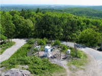
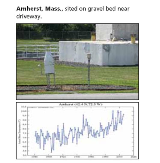
View the audit of surface stations in Massachusetts. View the audit of surface stations by state. Amherst, MA shown.

THAT IS NOT ALL; OTHER CONCERNS NOTED
1) To collect and communicate the data, the goverment relies on citizen volunteers from private folks to prisoners in jail. It is a triumph of service yet these efforts result in missing data—roughly 30 percent.
2) Instrument shelters were painted with white wash paint since the late 1800s. Due to concerns over the lead based paint, a few decades ago laytex replaced the white wash. Studies have shown that the laytex runs warmer.
3) In the 1980s, new instrument towers were introduced called MMTS. Because the output screen needs to be placed indoors, the unit must be cabled to a building, raising many siting issues due to this limitation.
This week 150,000 copies of the surface stations report landed on the desk of politicians.
The National Weather Service (NWS) and the National Climatic Data Center (NCDC) are well aware of the issues that exist and have been for some time. In response they have established a new automated temperature network at 114 sites called the CRN--Climate Reference Network. The sites will take measurements every 30 seconds, averaged out every 5 minutes. Temperatures are then transmitted hourly.Originally there were to be 250 sites with two sites in close proximity for redundancy. Budget cuts scaled things back. These sites are considered to ensure the highest quality of temperature data and are meant to tease out national climate trends. In New England, there are two CRN sites in Maine, one site with redundancy (two in close proximity) in Durham, New Hampshire and in Kingston, RI. There are no CRN sites in Massachusetts. The network was only recently established, but so far the data collected is said to match quite well with the temperature data from the USHCN.
The government also plans to establish a much larger network called the HCNM---basically the M stands for “modernized.” This other network will be 1000 sites strong across the country and will have the density to capture regional climate trends. The surface stations will also be automated and will be located on public lands to prevent any urban encroachment or the need to move the stations. So far none of the instrumentation has been installed, only prototypes are being tested in the field at this time. Due to budget constraints, this new network will take years, maybe even more than a decade to install. The Blue Hill Weather Observatory is being inspected as a potential site for addition to this new network. Read this full post here. Kudos to Mish Michaels and WBZ for their willingness to present this critical issue at this very critical time when very important decisions are being made in Washington. Got it mostly right. They were not aware NOAA removed the urban adjustment in 2007.