Guest Blog from Dr. Madhav Khandekar
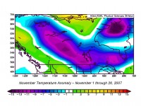
If you are following the Canadian weather patterns, the Prairies are in DEEP FREEZE and I recall my Edmonton days from Spring 1971 thru December 1974. In January 1972 I remember one week then when temperatures were in the range -35 to -45C all thru the week! This is what is happening there right now. For example, Winnipeg today had a wind chill of -30C , real temperature about -20C, Regina -25C. Two days ago Regina had a parade for their football team winning the Grey Cup (equivalent of your Super Bowl) and fans were out in the street when temp was about -20C and wind chill -30C! You have to be a real football fan to be out in such a brutal weather!

Temperature Anomalies (degrees C) thanks to NOAA CDC November 1-26, 2007. For larger image go here.
This is shaping into one of the strong La NIna phase with SSTs in Nino (1+2) region very low and also elsewhere in Nino 3 & 3.4 region. I expect this winter to be quite cold over the Prairies and with some luck we will have cooler winter on the Great Lakes vicinity in southern Ontario as well. So far the central Ontario and lake districts (Sudbury, Parry Sound, Muskoka) have had a fair amount of snow, frequent snowsqualls and ski activity already started. I recall a document prepared by one of the former Environment Canada advisor Henry Hengeveld in early 1980s with a bold prediction that “ski activity in southern and central Ontario would vanish in 25 yrs (by 2000-2005) because of lack of snow due to global waming!” The reality is far from that prediction, snow accumulation has in fact increased in southern and central Ontario in the last few years.
Madhav Khandekar specializes in understanding extreme weather events in Canada and in other parts of the world. He holds a B.Sc. in Mathematics and Physics, a M.Sc. in Statistics from India (Pune University) as well as both M.Sc. and Ph.D. degrees in Meteorology from Florida State University.


