


By Joseph D’Aleo, CCM
Early in April, we will update on the Weatherbell Analytics blog, the snow season and the half dozen plus cities, where it will rank in the top ten or even five snowiest ever. As we showed in yesterday’s post, for the second year in a row had 4 important ranking northeast snowstorms according to NOAA NCDC NESIS scale. The winter was the third straight winter with memorable storms. 9 of the 44 top impact storms observed since 1956 have occurred since March 2009. 1 in March 2009, 4 in 2009/10 and 4 more in 2010/11. 6 were classified as major, 2 significant and 1 notable.
Go here to see NOAA NESIS Northeast Snowfall Impact Scale. Click on the storm date and see the map of the snowfall amounts.
Also Joe Bastardi will be introducing in the next week on his blog, the Weather Bell hurricane power and impact scale, we will use this upcoming season. I am excited by his approach which will use the pressure and wind and changes in intensity. In early April Dr. William Gray will be updating his seasonal outlook. In December, he and his associate Dr. Philip Klotzbach had forecast another active season with 17 names storms, 9 hurricanes and 5 major hurricanes (CAT 3+). They believe that unlike last year, the mainland may not be as lucky with a 49% of landfall along the east coast and Florida (climatological average is 31%) and 48% chance in the Gulf versus the 30% average.
In this excellent presentation at the AMS Annual meeting, Dr. Gray talked about why the activity has increased since the AMO (Atlantic Multidecadal Oscillation) flipped positive in 1995. See his analysis here.
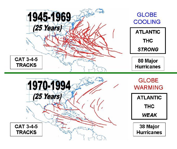
Bill shows how he believes activity and the AMO relate to the strength of the Thermohaline Circulation (THC). He concludes: When the THC is strong the Atlantic atmospheric and oceanic sub-tropical gyres are weaker than normal and we have much more Atlantic major hurricane activity. When the Atlantic THC is weaker than average, the gyres are stronger than normal and we encounter less major hurricane activity in the Atlantic. Below, enlarged.

The tracks of major (Category 3-4-5) hurricanes during the 16-year period of 1995-2010 when the Atlantic thermohaline circulation (THC) was strong versus the prior 16-year period of 1979-1994 when the THC was weak. Note that there were approximately 2.5 times as many major hurricanes when the THC was strong as when it was weak.

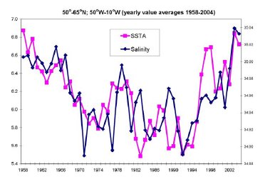
Illustration of the strong association of annually-averaged North Atlantic SSTA and North Atlantic salinity content between 1958 and 2004.
Enlarged.
See also the Weatherbell post on the September Surprise, the Hurricane of ‘38. “The year is 1938. Another hot Dust Bowl summer was drawing to a close. The heat has not been as extreme this summer as in some of the prior summers that decade, but it still had been hot, by most all accounts, too hot. The hurricane season was well underway. This one had been uneventful...so far.”