NASA Earth Observatory
Update: Here is the image of May 7, 2009 (below, enlarged here). Volcanic ash from last month’s Iceland eruption has doubled back southward, delaying most of today’s transatlantic flights between Europe and the U.S. and shutting airports in Portugal and Spain. A massive 1,200-mile long ash cloud is hovering over Europe from Iceland to northern Spain, Europe’s flight control agency said today. To get around the cloud, transatlantic flights have to be rerouted northward over Greenland, or southward over Spain—adding at least an hour to flight times in both directions.

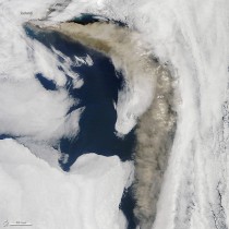
After more than a week of relatively subdued activity in late April, Iceland’s Eyjafjallajokull Volcano began a fresh round of explosive ash eruptions in the first week of May. On the morning of May 6, 2010, the Moderate Resolution Imaging Spectroradiometer (MODIS) on NASA’s Terra satellite captured this view of a thick plume of ash blowing east and then south from the volcano. Clouds bracket the edges of the scene, but the dark blue waters of the Atlantic Ocean show in the middle, and above them, a rippling, brownish-yellow river of ash.
Ash clouds like this are impressive to see, and they can have a dramatic influence on air quality and vegetation, including crops. In Iceland, the ash from Eyjafjallajokull has settled thickly on the ground, posing a threat to livestock and wildlife. The risk of engine damage due to ash has grounded European air traffic repeatedly.
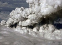
Despite their dramatic appearance, however, these ash plumes are insignificant when it comes to long-term affects on global climate. What matters most to the climate isn’t even visible in images like this. For an eruption to have an influence on global climate, the event must be explosive enough to push sulfur dioxide into the stratosphere, which is above the altitude where rain and snow occur.
Sulfur dioxide turns into tiny droplets of sulfuric acid. These light-colored droplets cool the Earth by reflecting sunlight back to space. Because it doesn’t rain in the stratosphere, the droplets can linger for months or years. Massive eruptions can cool the global average surface temperature by several degrees for several years.
In most cases, though, high-latitude eruptions have little influence on global climate even when they are explosive enough to inject sulfur dioxide into the stratosphere; the reflective particles rarely have a chance to spread around the globe. Stratospheric air generally rises above tropical latitudes, spreads toward the poles, and then sinks back toward the lower atmosphere at high latitudes.
This circulation pattern means that stratospheric particles from eruptions in the tropics have a better chance of spreading all around the world, while particles from high-latitude eruptions are more likely to quickly sink back to lower altitudes. When they re-enter the troposphere, they are rapidly washed out of the atmosphere by rain and snow. Eyjafjallajokull’s high-latitude location means that its eruption probably won’t influence the global climate significantly.
ICECAP NOTE: It is true that tropical volcanism has more global impact as the ash and aerosols travel north and south and affect most of the globe while high latitude volcanoes find ash and gases limited more to the higher latitudes and tend to have effects that don’t last as long. But research by Oman (2005) showed northern hemispheric high latitude volcanoes influence the Arctic and North Atlantic Oscillations which can have a profound effect on the climate as we saw last summer and then this past winter with Redoubt and Sarychev and may this summer and next winter with Eyjafjallajokull, especially if the eruptions continue and become stronger and if it excites nearby larger Katla into action as past eruptions have. The stratosphere is lower in the polar regions than in the tropics where eruptions need to get well above 55,000 feet to have long term impact. In the polar regions a 30,000-40,000 foot ash and aerosol cloud can have impact. Some of the biggest eruptions in April and again May 6th reached above 30,000 feet. Read more on high latitude volcanoes here.
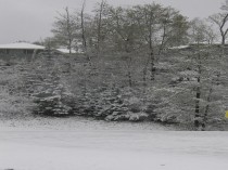
By the way the strong blocking led to a warm end of winter and early spring in eastern North America with a predominantly easterly flow and maritime air and early demise of snowcover in eastern Canada and northern New England which normally keeps the region chilly in the early spring. However there was that major late April snow in northern New England and snow last week as some cold air made its way south out of central Canada. And a record late snow in northeast Spain and parts of France last week. Snow fell the last few days across the northern tier states in the United States. This is the picture from northern Wisconsin from this morning.