Update:
See Steve Goddard’s comprehensive review region by region confirming the heavy snow occurred where temperatures were below normal not warm.
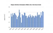
Rutgers snow analysis for this winter (Dec-Feb) for the northern hemisphere reported by Steve Goddard to be the third greatest. Three of the four snowiest Northern Hemisphere winters since 1967 have been in the last four years. Four of the five snowiest winters have been since CRU experts told us that children won’t know what snow is.
By Joseph D’Aleo, CCM, AMS Fellow
As we reported, the eco-pressure group, the Union of Concerned Scientists, as part of a continuing misinformation campaign sponsored a teleconference yesterday with a very confused Jeff Masters of Weather Underground, opportunist Mark Serreze of NSIDC and a UCS environmentalist. Their performance was a scientific disappointment to say the least as one scientist wrote me “Masters lost all my respect. Serreze never had it”. He didn’t mention the UCS. It is the crazy uncle no one talks about.
The Union of Concerned Scientists recall had sponsored a workshop on Mt. Washington in 2007 in which they promised ski areas that snow would be hard to come by even in northern areas and they might consider another profession. That very winter, northern New England set a record for the greatest seasonal snow and ski areas had the best year in their history. Across the hemisphere that winter was surpassed only by 1977/78, 2009/10. Through January this winter, the Northern Hemisphere had more snow than any of those years and will rank likely in the top 5.
The UCS was not alone in predicting warming means less snow. NOAA in their CCSP and the EPA in their TSD said most cities with winter averages near freezing (the case of most metros in the east) would see more rain and much less snow. Recall the IPCC stated: “Milder winter temperatures will decrease heavy snowstorms”. Recall RFK Jr. in 2008 promised DC children would be deprived of the fun of sledding due to warming - of course all-time record snows fell in 2009/10 and sleds and skiis were the only way to get around the DC area.
Now the alarmists have flipped their position claiming warming means more snow although it is a major stretch to think that would apply to Los Angeles, Houston, Dallas, New Orleans, and Atlanta in a warming world. But back to the teleconference.
“Heavy snowstorms are not inconsistent with a warming planet,” said scientist Jeff Masters. “In fact, as the Earth gets warmer and more moisture gets absorbed into the atmosphere, we are steadily loading the dice in favor of more extreme storms in all seasons, capable of causing greater impacts on society.” “The old adage, ‘It’s too cold to snow,’ has some truth to it,” said Masters. “A colder atmosphere holds less moisture, limiting the snowfall that can occur.”
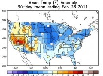
First of all the winter was colder than normal not warmer as can be seen by this preliminary analysis from NOAA CPC.
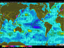
Second the global oceans are colder than normal, especially around the United States as seen from this UNISYS SST anomaly analysis.
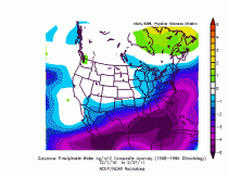
Third the amount of moisture in the air this winter was below normal (blues) in all the areas that had abnormal snow.
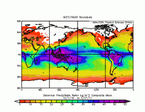
The actual tropspheric precipitable water content from surface to 500mb shows most the tropical atmosphere has over ten times the water content of the polar and middle latitudes.
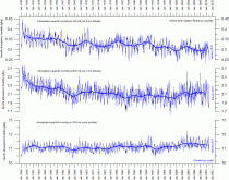
Marc Morano collated other scientist responses on Climate Depot. He adds (1) tropospheric relative and specific humidity has significantly declined since ‘safe CO2 levels’ of 1948, 2) atmospheric water vapor has declined since satellite measurements began in 1983, 3) there has been no statistically significant global warming since 1995. See in this peer review paper how CO2 enriched plants hold water better!
The snow resulted from a rapid cooling as we went from a strong El Nino to a strong La Nina and high latitude blocking consistent with a warm AMO mode and a still quiet sun (maybe some residual help from the high latitude volcanoes of recent years). Global temperature anomalies may have plunged more than a whole degree (F) from their peak last summer and early fall. February 2011’s anomaly (UAH) came in as -0.018F relative to the 30 year average. Recall global temperatures lag ENSO by about 7 months. Global teleconnections are most similar to the late 1950s, 1960s and 1970s when frequent snowy cold winters caused the world to increasingly think an ice age was coming.
Mark Serreze, director of the National Snow and Ice Data Center in Boulder, Colorado, said less sea ice in the Arctic translates to more moisture in the atmosphere, and could also cause an atmospheric circulation pattern in polar regions known as Arctic Oscillation.
“It’s still cutting-edge research and there’s no smoking gun, but there’s evidence that with less sea ice, you put a lot of heat from the ocean into the atmosphere, and the circulation of the atmosphere responds to that,” Serreze said.
He would not know cutting edge research if he fell over it. Forecasters were using the Atlantic Multidecadal Oscillation in forecasting temperatures for over a decade. It correlates very strongly with the Northern Hemispheric temperatures and with wintertime North Atlantic Oscillation and the Arctic Oscillation. Even the IPCC talks about the natural cyclical behavior of the AMO (60-70 year cycle). The warm AMO mode which began in 1995 biases the atmosphere towards a negative AO and NAO. It also contributes to less arctic ice as the warmer than normal waters near the Barents Sea work their way under the ice and thin it from the bottom. See.
Before Serreze took over NSIDC seeing the huge grant funding windfall opportunity, an honest scientist in their blog in 2007 admitted the roles of the oceans in arctic ice and the uncertainty that existed in the science:
“One prominent researcher, Igor Polyakov at the University of Fairbanks, Alaska, points out that pulses of unusually warm water have been entering the Arctic Ocean from the Atlantic, which several years later are seen in the ocean north of Siberia. These pulses of water are helping to heat the upper Arctic Ocean, contributing to summer ice melt and helping to reduce winter ice growth. Another scientist, Koji Shimada of the Japan Agency for Marine - Earth Science and Technology, reports evidence of changes in ocean circulation in the Pacific side of the Arctic Ocean. Through a complex interaction with declining sea ice, warm water entering the Arctic Ocean through Bering Strait in summer is being shunted from the Alaskan coast into the Arctic Ocean, where it fosters further ice loss.” Many questions still remain to be answered, but these changes in ocean circulation may be important keys for understanding the observed loss of Arctic sea ice.”
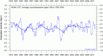
CO2 has nothing at all to do with it. Cold open arctic waters serve as a major sink of CO2 just as the warm tropical waters serve as a source. Roger Pielke Sr. suggests the ocean heat content (OHC) as a more robust measure of temperature trends. Models suggest OHC should be rising rapidly as the greenhouse gases build, especially in the tropics. Here is the buoy based OHC in the top 300 meters of the equatorial from NOAA (between 5 degrees north and south of the equator) Pacific from 130 E to 80W. During El Ninos, the eastern half is warm and the west cool, in La Ninas the eastern half is cool and the western warm. The fact there is not net warming, instead actually a slight cooling of the entire belt may the most damning proof that global warming is nothing more than a government funded political campaign.
Meanwhile, check out the interesting snow stories as we enter the last quarter mile of the winter season. Ask the people in these areas whether they think global warming is something to worry about.
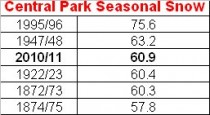
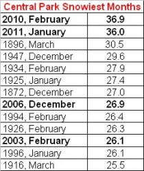
And Central Park’s snowiest months:
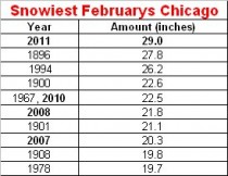
Chicago had a helleva February.
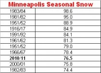
Minneapolis is climbing the top ten list of snowiest winters (second snowiest for the December to February period behind only 1966-67).
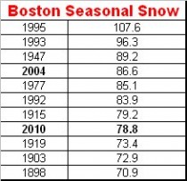
As is Boston.
