


In an apparent bid to counter skepticism of the specious claim that global warming caused the string of heavy snowfalls in the US and Europe this winter, a media teleconference with “two leading climate and weather experts” has been scheduled for Tuesday, March 1, 2011. Mark “death spiral” Serreze and Jeff Masters will “discuss how a rise in the number of snowfalls of 6 inches or more may be related to an increase in moisture in the atmosphere,” allegedly due to global warming.
Major problems with this argument include weather balloon and satellite data showing that 1) tropospheric relative and specific humidity has significantly declined since the ‘safe CO2 levels’ of 1948, 2) atmospheric water vapor has declined since satellite measurements began in 1983, 3) there has been no statistically significant global warming since 1995, and 4) the IPCC predicted milder winters and that the “milder winter temperatures will decrease heavy snowstorms.”
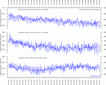
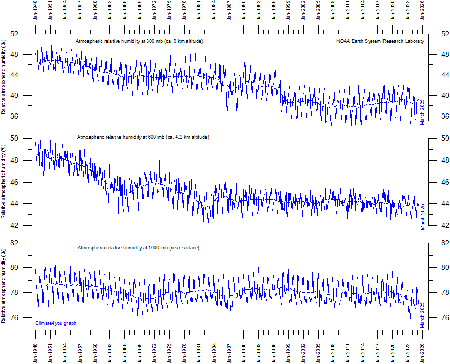
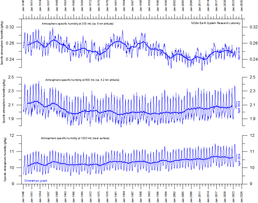
From the excellent site Climate4you.com: Specific atmospheric humidity (g/kg) at three different altitudes in the lower part of the atmosphere (the Troposphere) since January 1948. The thin blue lines shows monthly values, while the thick blue lines show the running 37 month average (about 3 years). Data source: Earth System Research Laboratory (NOAA). Data description by Kalnay et al. (1996). Last month shown: January 2011. Last diagram update: 13 February 2011.
Most climate models assume that as an increasing amount of atmospheric CO2 induces slightly increasing atmospheric temperatures, the overall evaporation will increase from the planet surface, and thereby the specific humidity of the lower part of the atmosphere (the Troposphere) will increase as well. As water vapour is the most important greenhouse gas, additional warming will come about, resulting in a much larger temperature increase than that induced from CO2 alone. Climate models therefore, in general, assume the relative Tropospheric humidity to remain more or less stable, as increasing air temperatures are compensated by increasing specific humidity.
The above diagrams indicate that none of this has been the case since 1948. Only near the planet surface, the relative humidity has remained roughly constant (although with variations), but in the remaining part of the Troposphere below the Tropopause the relative humidity has been decreasing. Even for the specific humidity, this appears to be the case.
MEDIA ADVISORY AND DAYBOOK ITEM FOR TUESDAY, MARCH 1, 2011
CONTACT: Randy Rieland, Union of Concerned Scientists, 202-331-6959
TELEPHONE PRESS CONFERENCE
CLIMATE EXPERTS TO LOOK BACK AT WILD WINTER OF 2010-2011 AND EXPLAIN THE LINK BETWEEN HUGE SNOW STORMS AND GLOBAL WARMING.
SCIENTISTS ALSO WILL LOOK FORWARD AT THE IMPACT EXTREME WINTER WEATHER EVENTS COULD HAVE THIS SPRING
The Union of Concerned Scientists (UCS) will hold a telephone press conference featuring two leading climate and weather experts explaining what is behind the string of heavy snowfalls in the U.S. and Europe this winter and put the extreme weather in the context of climate change.
They will discuss how a rise in the number of snowfalls of 6 inches or more may be related to an increase in moisture in the atmosphere and how Arctic warming and the shrinking of Arctic sea ice to record lows also may have been a factor in generating major winter storms.
Looking ahead, the scientists will talk about what we can expect in the coming months as the potential combination of earlier spring weather and deep snowpack raises the threat of serious flooding, particularly in the upper Midwest.
WHO
Mark Serreze, director of the National Snow and Ice Data Center, Boulder, Colorado
Jeff Masters, director of Meteorology at Weather Underground
Todd Sanford, climate scientist, Union of Concerned Scientists
WHEN
Tuesday, March 1, 2011, 11 a.m. EST
WHERE
The comfort of your own office. Call: (866) 961-7940; Conference ID: UCS winter and climate change teleconference
Icecap Note: Be sure to dial in and express your opinion if the opportunity arises.
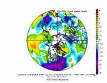
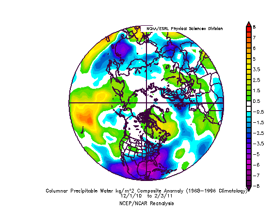
See how precipitable water is below normal (blue and purple) this winter in the areas of heavy snows. Ocean temperatures are below normal around these areas as well. Jeff Masters has my respect for his fine work on Wundergorund and as a hurricane forecaster, but he has aligned himself with folks and dogma that will hurt his future reputation. I think Serreze is an opportunist not to be trusted and the UCS is an enviro group posing as scientists and should always be ignored. They were front and center in 2007 on Mt Washington telling ski areas and the maple sugar industry that global warming ensured warmer winters, much less snow now they are organizing a teleconference to state the opposite.
See also this report from Chicago about the snowblitz in February. This is the snowiest February on record for Chicago. Four of the top ten snowiest Februarys in Chicago have occurred since 2007. Also it snowed in the Los Angeles area today - see pictures from Burbank and Los Angeles Universal City here.