


By Joseph D’Aleo on Intellicast
After another La Nina season with again a lot of snow and precipitation in the north central, another relatively active tornado season was expected and so far it has delivered on that promise. However given the La Nina was not as strong and the rebound in the Pacific towards El Nino is a month earlier than last year, the number of storms so far, have been less. It looks like May will fall well short of last May’s 461 tornadoes.
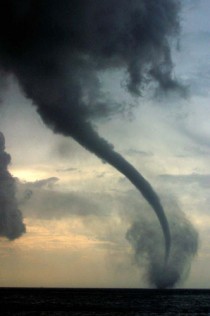
Cedar Hill, Texas, Photo credit Pat Skinner, TTU
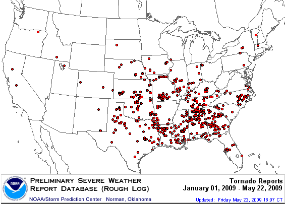
The annual summary to date can be found here. The tornadoes so far in 2009 have been in the southeast quadrant of the nation. Climatologically, that is where the season normally begins.
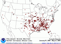
See larger image here.
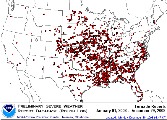
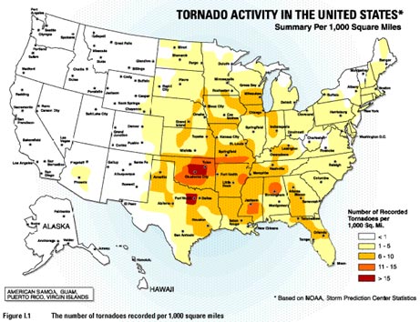
In 2008, the tornadoes when all was said and done, were found in all but 4 of the lower 48 states.
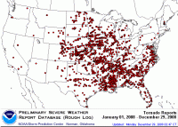
See larger image here.
As we move into summer, expect the activity to shift north with the jet stream. The march of the season - climatology of tornadoes normally follows this depiction (source here).
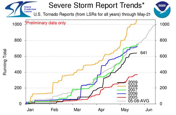
We are below the 5 year average for tornadoes for the season to date, below all but 2005.
See larger image here.
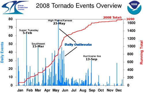
The activity was as usual concentrated in what is called tornado alley in the plains, Midwest to the Gulf. You can see in 2008 that the daily events peaked in May with the biggest day on the 23rd of May before falling off in summer as El Nino like conditions developed in the eastern Pacific. That is occurring a month earlier this year and perhaps, that explains the quieter May.
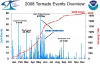
See larger image here.
The activity was as usual concentrated in what is called tornado alley in the plains, Midwest to the Gulf.

See larger image here.
The reason that this region is most vulnerable is that this is where the combination of moisture from the Gulf of Mexico, dry air in mid levels from Mexico, a strong jet with cold air aloft coming out of the Rockies and a boundary between still cool air to the north and the warm humid summer like air in the south all come together. Read more and see some useful links here.
By the way, last year, the alarmist media blamed the increase in tornados on global warming. Well guess what this year, stormchasers across Tornado Alley have been frustrated this spring by what seems to be a lack of tornadoes and severe weather. Indeed, VORTEX2, the largest tornado field study ever, has been running for more than two weeks now and has not seen one twister. Last week, Weather Channel Senior Meteorologist Stu Ostro speculated that global warming was the cause. Of course this is the normal, mother nature has a perverse sense of humor - projects to study east coast storms had no east coast storms that winter, just one passing front. You just knew that VORTEX2 would lead to a lack of storms to study. We need them to schedule a massive study of hurricanes and we will surely have a dud season.
As to Stu’s reasoning, a big ridge would lead to heat and dryness across the central states. Instead the region has been hit hard with a steady stream of progressive troughs with heavy rainfall and very little warmth (fuel for storms). These storms brought more toirnadoes in April 2009 than in April 2008.
See larger image here.
The real issue may instead be that the El Nino like conditions that came in late May last year shutting off severe weather activity in June 2008 came on a month earlier this year and severe weather activity has diminished in May.