


By Dr. Roy Spencer
...although this, too, shall pass, when La Nina goes away.
LA NINA FINALLY BEING FELT IN TROPOSPHERIC TEMPERATURES
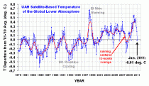
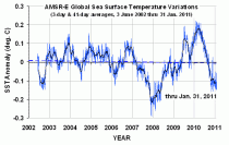
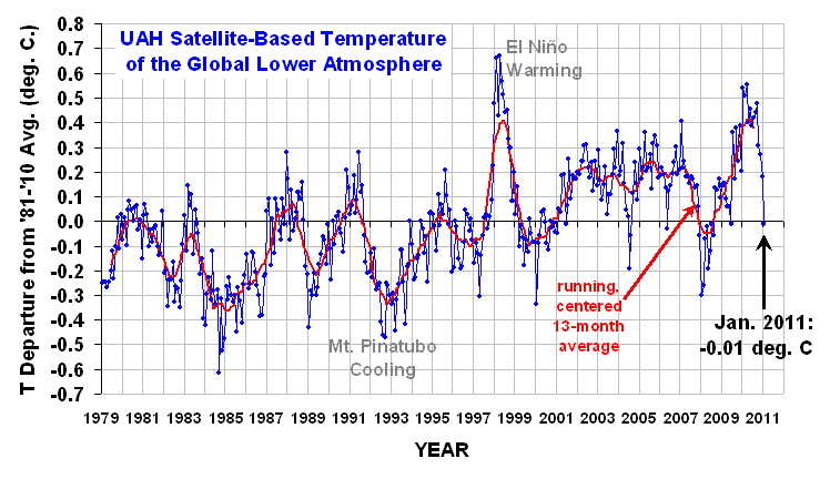
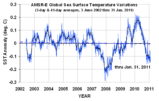
January 2011 experienced a precipitous drop in lower tropospheric temperatures over the tropics, Northern Hemisphere, and Southern Hemisphere. This was not unexpected, since global average sea surface temperatures have been falling for many months, with a head start as is usually the case with La Nina.
This is shown in the following plot (note the shorter period of record, and different zero-baseline):
SO WHY ALL THE SNOWSTORMS?
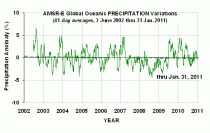
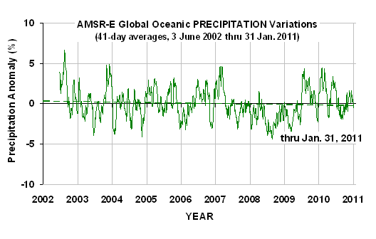
While we would like to think our own personal experience of the snowiest winter ever in our entire, Methuselah-ian lifespan has some sort of cosmic - or even just global - significance, I would like to offer this plot of global oceanic precipitation variations from the same instrument that measured the above sea surface temperatures (AMSR-E on NASA’s Aqua satellite):
Note that precipitation amounts over the global-average oceans vary by only a few percent. What this means is that when one area gets unusually large amounts of precipitation, another area must get less.
Precipitation is always associated with rising air, and so a large vigorous precipitation system in one location means surrounding regions must have enhanced sinking air (with no precipitation).
In the winter, of course, the relatively warmer oceans next to cold continental air masses leads to snowstorm development in coastal areas. If the cold air mass over the midwest and eastern U.S. is not dislodged by warmer Pacific air flowing in from the west, then the warm oceanic air from the Gulf of Mexico and western Atlantic keeps flowing up and over the cold dome of air, producing more snow and rain. The “storm track” and jet stream location follows that boundary between the cold and warm air masses.
See Roy’s full post and comments.
See also this GWPF post by David Whitehouse on the temperatures of 2010.