


By Anthony Watts, Watts Up With That
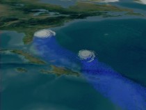
Two hurricanes approaching the coast of the United States, with the second hurricane slowed due to cooler waters caused by the track of the first
The Atlantic has been running warm lately, but that’s because there’s been little happening with Nature’s natural heat transporters. WUWT commenter SteveM pointed out something interesting in the latest SST image from NESDIS, but before we have a look at the animation I developed from that imagery, I thought we should have a look at the role that hurricanes play as heat engines.
First an animation from Goddard Space Flight Center:
And another, showing how the heat transport and surface cooling process operates.
From NASA SVS: As water vapor evaporates from the warm ocean surface, it is forced upward in the convective clouds that surround the eyewall and rainband regions of a storm. As the water vapor cools and condenses from a gas back to a liquid state, it releases latent heat. The release of latent heat warms the surrounding air, making it lighter and thus promoting more vigorous cloud development.
Now let’s watch this simple animation of the last two weeks of Sea Surface Temperatures and you’ll see the cool water tracks left by hurricanes Daniel and Earl:
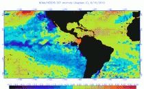
click here to enlarge and animate
You can see the cool tracks in the last frame. Note also the large and growing La Nina off the west coast of South America. It’s turning deep purple and on to black. Way cool. See post here.