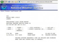
Special Weather Statement
National Weather Service Melbourne Fl
651 AM EST Saturday Jan 9 2010
Light sleet and snow flurries continue to mix with rain across Brevard, Lake, Orange, Osceola, Seminole and Volusia Counties.
Numerous surface observations and weather spotters continue to report rain mixing with light sleet and snow flurries across an area north of a line from Melbourne to Kenansville. Intermittent periods of a rain, sleet, and snow flurries with little to no accumulation are forecasted to continue across this same area through mid-morning.
Temperatures are continuing to fall across Indian River County and a brief period of a rain sleet mix may occur especially across northern portions of the county in Sebastian and Fellsmere.
Though temperatures remain just above freezing in most locations, patchy ice may develop on area roadways, creating hazardous driving conditions. Bridges, overpasses and low spots usually will develop ice first. Slow down and use caution if driving on area roadways this morning.
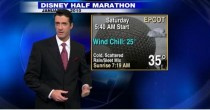
Orlando International Airport at 8am was reporting 30F and light freezing rain. Earlier reported ice pellets. EPCOT marathon this morning may find runners in sleet and temperatures in the low to mid 30s and wind chills in the mid 20s. See the morning WESH video with meteorologist Tony Mainolfi here. Still image capture here
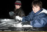
A rare scene for Florida below.
During the day, additional reports were received and plotted by the Melbourne NWS office here.
.jpg )
Also reports of snow flurries in Miami were received by the NWS, one report logged below (enlarged here). H/T Alexandre Aguiar, METSUL