|
Nov 28, 2008
International Poll: ‘Growing Public Reluctance’ to Support Global Warming Efforts
Peter O’Neil, Europe Correspondent, Canwest News Service
There is both growing public reluctance to make personal sacrifices and a distinct lack of enthusiasm for the major international efforts now underway to battle climate change, according to findings of a poll of 12,000 citizens in 11 countries, including Canada.
Results of the poll were released this week in advance of the start of a major international conference in Poland where delegates are considering steps toward a new international climate-change treaty to replace the Kyoto Protocol, which expires in 2012. There already are reports emerging that some countries, such as coal-dependent Poland, are pushing for special treatment to avoid making major commitments to slash carbon emissions during a global economic downturn. A file photo showd snow cannons blasting artificial snow on a slope in Kitzbuehel, Austria. Due to the uncommonly warm weather many European alpine ski resorts have no snow.
Less than half of those surveyed, or 47 per cent, said they were prepared to make personal lifestyle changes to reduce carbon emissions, down from 58 per cent last year. Only 37 per cent said they were willing to spend “extra time” on the effort, an eight-point drop.And only one in five respondents - or 20 per cent - said they’d spend extra money to reduce climate change. That’s down from 28 per cent a year ago. The Canadian results, from a poll of 1,000 respondents conducted in September, were virtually identical to the overall figures. There are no comparative figures for Canada because Canadians weren’t included in the global study in 2007.The 11 countries surveyed were Australia, Brazil, Canada, China, France, Germany, India, Malaysia, Mexico, the United Kingdom and the United States. There were 2,000 respondents surveyed in China, including 1,000 in Hong Kong.The survey was conducted as part of a joint collaboration between the financial institution HSBC and environmental groups, such as the Earthwatch Institute."There’s consumer reluctance that’s creeping in, and we’ve seen that some are being stunned into inaction by the enormity of the task,” said Earthwatch executive vice-president Nigel Winser.
Results of the poll suggested that 55 per cent of respondents in the 11 countries said their governments should be doing more by investing in renewable energy sources, such as wind, solar and wave power. That’s more than double the 27 per cent who wanted their governments to participate in Kyoto-style international agreements to reduce emissions. In Canada, the same portion favoured renewable-energy options, while 32 per cent supported collective international efforts. “People believe governments are focusing too much attention on indirect actions that pass responsibility for climate change onto others, such as increasing taxes on fossil fuels, encouraging individual environmentally friendly activities and participating in international negotiations, such as the Kyoto Protocol,” the report said.
“More needs to be done to inform consumers about measures such as green taxation or carbon trading to help them understand how tangible these can be. “The poll helps explain why outgoing Liberal Leader Stephane Dion had so much difficulty during the election campaign trying to sell his Green Shift platform that proposed a carbon tax in order to encourage emission reductions. Earthwatch’s Winser said the silver lining in the poll was that it stresses public dissatisfaction with the performance of all governments. “We welcome this survey because it shows that individuals want their governments to do more."HSBC was unable to provide the poll’s margin of error. Read post here.
Nov 25, 2008
Fiery Czech Leader Klaus Poised to Be EU President—Called Gore an ‘Apostle of Arrogance’
By Dan Bilefsky, New York Times
In the 1980s, a Communist secret police agent infiltrated clandestine economics seminars hosted by Vaclav Klaus, a fiery future leader of the Czech Republic, who had come under suspicion for extolling free market virtues. Rather than reporting on Marxist heresy, the agent was most struck by Mr. Klaus’s now famous arrogance. “His behavior and attitudes reveal that he feels like a rejected genius,” the agent noted in his report, which has since been made public. “He shows that whoever does not agree with his views is stupid and incompetent.”

Decades later, Mr. Klaus, the 67-year-old president of the Czech Republic - an iconoclast with a perfectly clipped mustache - continues to provoke strong reactions. He has blamed what he calls the misguided fight against global warming for contributing to the international financial crisis, branded Al Gore an “apostle of arrogance” for his role in that fight, and accused the European Union of acting like a Communist state. Now the Czech Republic is about to assume the rotating presidency of the European Union and there is palpable fear that Mr. Klaus will embarrass the world’s biggest trading bloc and complicate its efforts to address the economic crisis and expand its powers.
His role in the Czech Republic is largely ceremonial, but he remains a powerful force here, has devotees throughout Europe and delights in basking in the spotlight. “Oh God, Vaclav Klaus will come next,” read a recent headline in the Austrian daily Die Presse, in an article anticipating the havoc he could wreak in a union of 470 million people already divided over its future direction. Read more here. See another story on this here.
Icecap Note: Despite the horror expressed by the alarmist media including the NYT, Klaus would bring a new vision and leadership to the EU where there is increasing skepticism fed by economic realities in countries such as Italy, Poland, Germany and even by the public in the UK about the futility of, need for, and economic perils of emission controls. See his inspiring talk at the Heartland ICCC in March 2008 here.
Nov 25, 2008
GHCN Updates
By Steve McIntyre, Climate Audit
In its land surface temperature calculations, NASA GISS is little more than a distributor for NOAA GHCN. As Gavin Schmidt explained, they spend no more than 0.25 man-years on this product, which permits negligible (if any) quality control. Although there are 7280 stations in the GHCN network, only a fraction of these occur as up-to-date records in GHCN (or their distributor), even from countries where up-to-date information is easy to locate (e.g. Canada, New Zealand). I’ve discussed this bizarre failure to update station data on many occasions in the past.
Aside from seemingly poor practice, a further issue for me and others is whether some kind of bias has been introduced into the system by the discontinuity. Assessing this potential bias is not a small job and one that NOAA and NASA should obviously have done long ago and existing literature does not do so. An obstacle to assessing such a bias has been the lack of any clear description of the update program. In my recent review of the data, I noticed a couple of scraps of information and have now constructed what I believe to be a reasonable accurate inventory of the stations that are included in the GHCN update program.
Peterson et al (BAMS 1997) reported the following update procedure: Of the 31 sources, we are able to perform regular monthly updates with only three of them. These are 1) the U.S. HCN, 1221 high quality, long-term, mostly rural stations in the United States; 2) a 371-station subset of the U.S. First Order station network (mostly airport stations in the United States and U.S. territories such as the Marshall and Caroline Islands in the western Pacific); and 3) 1502 Monthly Climatic Data for the World stations (subset of those stations around the world that report CLIMAT monthly code over the Global Telecommunications System and/or mail reports to NCDC). Other stations will be updated or added to GHCN when additional data become available, but this will be on a highly irregular basis.
When they said that the “other stations” would be updated on a “highly irregular basis”, they were not joking. In the 11 subsequent years, as far as I can tell, there have been no such updates. We’ve already collated information on the 1221 USHCN sites, but the GHCN website unfortunately doesn’t provide any lists of either the 1502 MCDW stations or 371 First Order stations.
NASA GISS makes an effort to adjust for UHI. As noted elsewhere, their procedure in the US is considerably different than their procedure outside the US, as, in the US, the USHCN network, whatever its warts, provides many stations that are not in urban airports. There is scattered information on non-US stations, but this is clearly a major lacuna at present (and I’m sending a copy of this list to Anthony in the hope that this topic will interest him - which seems likely given the interesting recent posts at his site on Verhoyansk in Russia). The Russian (and western China) sites seem like excellent first targets as they have a lot of leverage in overall land-based aggregates. Read more of the post and comments here.
Read also Climate Audit post on the NOAA GHCN comparison with NASA UAH global temperatures here.
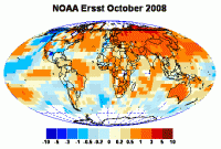
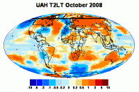
While the major patterns are similar in both data sets, there are some intriguing differences. NOAA surface coverage of the Southern Hemisphere looks decidedly scrappy beside UAH. While both NOAA and UAH show a cool “ridge” in the ocean offshore western Europe, it’s much larger in the UAH version. The tropical Pacific and northern Pacific are cooler in UAH. But it’s not all the same direction - UAH western Canada is warmer than NOAA western Canada.
Nov 24, 2008
Indonesia’s Climate Follows the Sun
By Dr. Willie Soon and Lord Christopher Monckton
Carbon dioxide is not an air pollutant. It is plant food. All life on Earth depends on it. It is natural. It forms the bubbles in bread, champagne, and Coca-Cola. You breathe it out, and plants breathe it in. The Earth contains a lot of CO2, but the atmosphere contains so little that the United Nations’ Intergovernmental Panel on Climate Change (IPCC) rightly calls CO2 a “trace gas”. A scientific mystery is why the air does not hold more CO2 than it does. Half a billion years ago, there was almost 20 times today’s CO2 concentration.
Most farmers would prefer to grow crops under much-higher concentrations of CO2 than today’s 385 parts per million - less than 1/25 of 1 percent of the atmosphere. To feed the world, low CO2 concentration is not such a great idea. High concentrations are better, and they cause no harm. Experiments have shown that even delicate plants such as orchids thrive at CO2 concentrations of 10,000 ppm. That is why U.S. Supreme Court Justice Anthony Scalia has declared that if CO2 is to be labeled an “air pollutant”, then so must Frisbees and flatulence.
What about the danger of overheating the Earth by CO2? Al Gore is spending $300 million telling us “global warming” will be a catastrophe. Yet a survey of 539 scientific papers containing the words “global climate change” and published between January 2004 and February 2007 found not a single one that provided any evidence that “global warming” would be catastrophic. It does not matter how many scientists or politicians say that more CO2 will cause a catastrophe. To true scientists, what matters is whether any real-world data support the idea.
If CO2 is a powerful greenhouse gas, we would have seen a great warming trend in Indonesian temperature history. We haven’t. Recent temperatures, according to the Tyndall Centre for Climate Change Research, have been scarcely warmer than they were 70 to 100 years ago. Instead of a strong warming trend, the Indonesian data are dominated by year-to-year changes and natural oscillations every 50 to 100 years.

Look to matahari (the sun in Bahasa Indonesia) rather than CO2 as the key player in Indonesia’s climate. Read more here.
Nov 22, 2008
Myths About Energy Threaten Future of Nation
By Barry Cleveland, Carmi Times
Fossil fuels are not ruining the environment, the world is not running out of oil and the U.S. can never be energy independent.Brad Richards, executive vice president of the Mt. Vernon-based Illinois Oil & Gas Association, took issue Thursday in Carmi with “three myths that threaten our country.”
He also took issue with the idea that the world is running out of oil. U.S. crude oil production peaked in the early 1970s and it may well be that world production has peaked recently, he said. But there will be no precipitous decline in production across the globe, he said. Instead, “Supply and demand will reach an uneasy equilibrium. And we’ll have a bumpy plateau of production for decades to come; extreme volatility will be the rule."The world is not running out of oil, he said, but it is running out of cheap, easily-found oil. Still, “there’s no way to run away from oil” entirely, he cautioned.Richards told the group that U.S. energy independence is “neither do-able nor desirable.” The truth is that the world is becoming more interdependent, he said, and unrealistic talk of energy independence hampers realistic discussion of the matter.
“It’s feel-good talk,” he said, but even aggressive development of alternative energy sources wouldn’t begin to provide the volume of energy now derived from fossil fuels."The truth is,” said Richards, “that we’re all married to fossil fuels.” And he predicted that this won’t change for 30 to 50 years, adding that the U.S. should “accept the reality of energy interdependence.” The club was told that crude oil now provides about 39 percent of the energy that the U.S. uses, natural gas 24 percent, coal 23 percent, nuclear power eight percent and hydroelectric power three percent. And Richards noted that environmentalists don’t like any of these sources.
Sadly, however, just as the nation can’t drill its way to energy independence, it can’t build enough windmills or install enough solar panels to replace fossil fuels.There are encouraging signs. U.S. natural gas production is expected to increase by eight percent this winter to a 35-year high, thanks to higher prices and new technology. What’s going on in the U.S. industry is “amazing” and “unbelievable,” Richards told the club, with horizontal drilling and other technologies being used to find and exploit huge gas fields. While admitting that John McCain was not the ideal candidate of the U.S. energy industry, Richards made it clear that the industry has little enthusiasm for the president-elect.
Barack Obama called for a new windfall profits tax on oil when the price of crude was over $100, Richards said. A similar tax didn’t work in the ‘70s; it increased the nation’s dependence on foreign oil, depressed domestic exploration and generated less than 25 percent of what was projected. More of the same could be expected if a new tax were implemented now, he added."Let free markets, not the government, make energy choices,” Richards told the crowd. Asked about the viability of tar sands and oil shales as energy sources, the speaker said they’re realistic if crude oil stabilizes at $90 a barrel or so. Read more here.
|
|
|
|

