Mar 22, 2008
Climate Facts to Warm To
By Christopher Pearson, The Australian
Catastrophic predictions of global warming usually conjure with the notion of a tipping point, a point of no return. Last Monday - on ABC Radio National, of all places - there was a tipping point of a different kind in the debate on climate change. It was a remarkable interview involving the co-host of Counterpoint, Michael Duffy and Jennifer Marohasy, a biologist and senior fellow of Melbourne-based think tank the Institute of Public Affairs. Anyone in public life who takes a position on the greenhouse gas hypothesis will ignore it at their peril.
Duffy asked Marohasy: “Is the Earth still warming?” She replied: “No, actually, there has been cooling, if you take 1998 as your point of reference. If you take 2002 as your point of reference, then temperatures have plateaued. This is certainly not what you’d expect if carbon dioxide is driving temperature because carbon dioxide levels have been increasing but temperatures have actually been coming down over the last 10 years.”
Duffy: “Is this a matter of any controversy? It’s not only that it’s not discussed. We never hear it, do we? Whenever there’s any sort of weather event that can be linked into the global warming orthodoxy, it’s put on the front page. But a fact like that, which is that global warming stopped a decade ago, is virtually never reported, which is extraordinary. People like Kevin Rudd and Ross Garnaut are speaking as though the Earth is still warming at an alarming rate, but what is the argument from the other side? What would people associated with the IPCC say to explain the (temperature) dip?” Marohasy: “Well, the head of the IPCC has suggested natural factors are compensating for the increasing carbon dioxide levels and I guess, to some extent, that’s what sceptics have been saying for some time: that, yes, carbon dioxide will give you some warming but there are a whole lot of other factors that may compensate or that may augment the warming from elevated levels of carbon dioxide. Read more here
Mar 20, 2008
All-Time Record Snows Creating Havoc in Canada
By Joseph D’Aleo, CCM
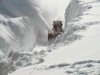
There are many media reports on the impact of the records snows. This one from the Agence France-Presse entitled “Record Snowfall Provokes ‘Snow Rage’ in Canada” A record snowfall in eastern Canada this winter has inspired some, crushed others, led to a rash of snow-blower thefts and incited at least two armed clashes, authorities said Wednesday. Police and psychologists describe the latter incidents as “snow rage,” akin to road rage or assaults by frustrated drivers in traffic. Quebec City police say they received more than a dozen calls this winter from warring neighbors upset that snow was being shoveled onto their driveway or sidewalk by the folks next door. The city was buried this winter in a record 460 centimeters (183 inches) of snow, and is running out of places to put the fluffy white powder until spring arrives and it melts.

What major eastern Canada snow looks like
In nearby Montreal, where residents are recovering from a ninth major snowstorm this season, a man was charged this week with threatening a fellow motorist with a toy gun over a rare parking spot on a snow-clogged street. And in likely the worst case, an elderly Quebec City man pulled a 12-gauge shotgun on a female snowplow operator on Sunday for blowing snow onto his property, after warning her. “How can you fight a three-ton snow-blower?” he told the Globe and Mail newspaper, accusing her of trying to run him over with the plow. “It takes a man who stands up.” “People are sick of snow,” Quebec police spokeswoman Sandra Dion told AFP.
In this story, in the Montreal Gazette, entitled “City Close to Breaking Snow Record” they reported “So far this winter, 347 centimetres of snow has fallen in Montreal. The city needs another 37 centimetres of snow to break the record of 383 centimetres of snowfall set in 1971.” “It is only March 10 so we still have a chance to break the record,” said Environment Canada meteorologist Andre Cantin. “It is common to get big storms in March and last year we received 15 centimetres in April.”
Finally this story by the UK Met Office, we read “Thick ice in the port of Sydney, Nova Scotia, resulted in a ferry being blocked, coast guard officials have said. United Press International reported on March 19th that a Canadian Coast Guard icebreaker headed to the port to assist the vessel on Wednesday.”
Mar 19, 2008
Impressive Increases in Sea Ice Extent Both Hemispheres
Joseph D’Aleo, CCM with data from The Cryosphere Today, NSIDC
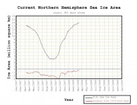
After diminshing to the lowest levels of the satellite era (since 1979) this past September, the arctic ice has recovered dramatically and coverage is about 1 million square km greater than last year at this time and within 500,000 square km of the longer term average. The ice has increased 11 million square km since the September minimum.

See larger image here
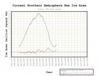
In the Southern Hemisphere, the ice which set a new record last winter is already increasing rapidly and is running nearly 40% ahead of where it was last year at this time. See the anomaly chart here. Below is the Southern Hemisphere ice extent graph.

See larger image here
Not surprisingly the global sea ice extent is above the long term average. Also not surprising that the alarmist PR machine picks this time to issue a release and Andy Revkin of the New York Times to blog on the report from World Mountain Glacier Monitoring Service, which is supported by the United Nations Environment Program, that the world glacial melting is increasing with no end in sight (report covers the years through 2006). They will return their attention to the arctic ice when the normal spring melt begins, ignoring once again the incredible ice happenings in the Southern Hemisphere.
Despite this increase in arctic ice extent, the loss of old, thick ice has continued through the winter months, despite the unusually cold weather deriving from La Nina conditions in the Pacific according to NASA. It is being replaced by less saline first year ice. The winter ice loss is thought to be driven mainly by the transport of old flows from Arctic waters out into the Atlantic Ocean as was the case last summer. The currents driving this are stronger than usual as a consequence of another natural cycle, the Arctic Oscillation. First year ice is more easily melted than old ice. It will be interesting to see what happens in the months ahead with a more negative AO (it was positive much of the winter leading to cold but a flow out of the arctic into the Atlantic).
Anthony Watts has an interesting post this morning entitled Deja-Vu All Over Again: Climate Worries of Today also Happened in the 20’s and 30’s with newspaper stories you could reprint today on temperature, glaciers and arctic ice worries.
Mar 18, 2008
Winds of Change
By Maggie Thauerskold, Helsingborg, Sweden
If you follow the climate debate you have probably noticed a slight change. What was formerly referred to as “global warming” is now called “climate change”. Perhaps to safeguard the case against a sudden 180-degree swing. This record cold winter has paralyzed many parts of the world despite the ever-growing amount of greenhouse gases billowing out from India and China.
Even though there is some uneasiness among the alarmists, they can’t just put down arms and acknowledge defeat. Too much money has already been invested. Too many jobs and reputations are on the line. So they add some wrinkles to the story and hope nobody will react. It’s like the story about the boiling frog. By making small gradual adjustments the alarmists hope change will be imperceptible.
Take for example John Tierney in The New York Times. It looks like someone at the NYT has finally caught on to the hoax but won’t admit it. So instead they try to gently slip in the truth.
All the faithful are of course a little worried. How can this super-cold winter happen? What is wrong with the climate change? Around the world, the modeling teams are sweating to adjust their calculations. At the same time other scientists, such as Ferenc Miskolczi, discover that “greenhouse warming” may be mathematically impossible. In short, the warming models assume that the atmosphere is infinitely thick. If on the other hand, you assume the atmosphere is about 100 km thick (about 65 miles) - which has the big advantage of being true, - the greenhouse effect disappears! Oops, no more global warming. What happens once this farce is finally exposed? Whose heads will roll? Read Maggie’s blog here.
Icecap Note: Of course it was not a record cold winter for the globe though it was for parts of the globe and the greenhouse effect doesn’t disappear just the enhanced greenhouse model warming.
Mar 18, 2008
CO2 and Global Warming
Dr. Richard Lindzen in Ecoworld
Climate models forecast increasing temperatures on earth because of increasing levels of atmospheric CO2, but observational data appears to contradict this claim.
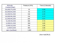
Subsequent to publishing the feature “The Fluid Envelope - A Case Against Climate Alarm” by Dr. Richard Lindzen, we received an email from a science journalist questioning one of the central assertions in Lindzen’s report. The writer wanted to know on what basis Dr. Lindzen was claiming there has been no significant warming in the last 10+ years. In response, Lindzen emailed the following table, showing temperature trends for the last 27 years. This data is based on global (including over the ocean) average temperature readings per year, per altitude, as reported by the U.K.’s Hadley Climatic Research Unit:

See larger table here
As the data indicates, over the past two decades, temperatures have actually declined in the upper troposphere, even though there has been some minor upward trends in temperature at sea level and lower altitudes. This completely contradicts conventional global warming models. As Dr. Lindzen explained in his follow up email:
“I used this data to show that the trend at 300 hPa was not about 2.5 x the surface trend which is what greenhouse warming [models] requires.” Apparently climate models that predict global warming ala increasing levels of atmospheric CO2 assume increasing temperature trends in the troposphere, where CO2 concentrates, and the reality is the troposphere is not getting hotter, it is getting cooler.
Before we radically rearrange the political economy of the world because some scientists claim anthropogenic CO2 is the cause of climate change, it might be worthwhile for anyone taking a position on the topic to consider whether or not this is indeed “well settled science.”
|
