Jul 05, 2009
Real Climate Permits The Continued Presentation Of Misinformation
By Roger Pielke Sr., Climate Science
Over at Real Climate, quite a few of the comments that they post continue to incorrectly interpret the observed behavior of the global average upper ocean heat content changes and sea level rise over the last 5 years (see the misinformation in the comments on the Real Climate weblog More bubkes).
The authors of Real Climate, unfortunately, are permitting this erroneous information (and personal insults) to be posted without their comments and correction. Apparently, the balance provided by Gavin Schmidt that I reported on in my weblog Gavin Schmidt’s Interview On Media Hype On Climate Science Issues was just a fluke. In this weblog, I will correct two of the major errors made in number of the comments on the Real Climate website.
One of the commentators on Real Climate list three papers that purportedly refute the finding of no recent upper ocean warming and that the sea level rise has flattened since 2006 . These papers are (1) Levitus S. et al. (2009) Global ocean heat content 1955-2008 in light of recently revealed instrumentation problems Geophys. Res. Lett. 36, L07608; (2) Cazenave A. et al. (2009) Sea level budget over 2003-2008: A reevaluation from GRACE space gravimetry, satellite altimetry and Argo Glob. Planet. Change 65, 83-88; (3) Leuliette E.W. and Miller L. (2009) Closing the sea level rise budget with altimetry, Argo, and GRACE Geophys Res. Lett. 36, art # L0406. I have already weblogged on two of these papers:
Sea Level Budget over 2003–2008: A Reevaluation from GRACE Space Gravimetry, Satellite Altimetry and Argo by Cazenave et al. 2008. This paper includes the text “From the results presented in this study, we see that confronting independent estimates of ocean and land contributions to sea level with altimetry results leads to a rather coherent picture for recent years variations. This can be summarized as follows: since 2003, sea level has continued to rise but with a rate (of 2.5 +/-0.4 mm/yr) somewhat reduced compared to the 1993-2003 decade (3.1+/-0.4 mm/yr).”
“The steric sea level estimated from the difference between altimetric (total) sea level and ocean mass displays increase over 2003-2006 and decrease since 2006. On average over the 5 year period (2003-2008), the steric contribution has been small (on the order of 0.3+/-0.15 mm/yr), confirming recent Argo results (this study and Willis et al., 2008).” This paper supports both conclusions in my recent weblogs (see and see) that the sea level rise has flattened and that the upper ocean heat content changes have been essentially flat since 2004.
On the Levitus et al paper, I weblogged on this in Comments On A New Paper ”Global Ocean Heat Content 1955-2008 In Light Of Recently Revealed Instrumentation Problems” By Levitus Et Al. 2009.
Even a causal view of the Levitus et al figure, which is reproduced in my weblog, shows that upper ocean heat content has been flat in their data for the last 4 years. The large rise just before than is suspicious (as I am told by colleagues working of this subject), and, moreover, is not consistent with the sea surface temperature trends for this time period (see the GISS data on the ocean surface temperature trends here at ). Thus even the group that Gavin Schmidt works for (GISS) presents data with no sharp spike that is at all consistent with the Levitus et al analysis and, moreover, the GISS analysis shows that the global average sea surface temperature has been essentially flat since 2002!
All of these analyses are consistent with no significant heating in the upper ocean and a flattening of sea level rise, and even more clearly, that these climate metrics are not “progressing faster than was expected a few years ago”. Real Climate has it backwards; these climate metrics are changing less than was expected a few years ago!
The Leuliette et al paper states “An analysis of the steric and ocean mass components of sea level shows that the sea level rise budget for the period January 2004 to December 2007 can be closed, we find that the sum of steric sea level and the ocean mass component has a trend of 1.5 ± 1.0 mm/a over the period.”
This finding is not flat, but it is not still does not support the claim by Real Climate that this climate metric “is progressing faster than was expected a few years ago”. In fact, this rate of sea level rise is even less than reported in Cazenave et al 2009! Read more here.
Jul 04, 2009
How The US Temperature Record is Adjusted
By Michael Hammer, Jennifer Marohasy Blog
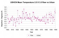
In the US, the National Oceanic and Atmospheric Administration (NOAA) collects, analyses and publishes temperature data for the United States. As part of the analysis process, NOAA applies several adjustments to the raw data. If we consider, the below graph, which shows, their plot of the raw data (dark pink) and the adjusted data (pale pink), it is obvious that the adjustments have little impact on data from early in the 20th century but adjust later temperature readings upwards by an increasing amount. This means that the adjustments will create an apparent warming trend over the 20th century. [Click on the above chart for a better larger view, this chart can also be viewed here.
NOAA state that they adjust the raw data for five factors. The magnitude of the adjustments are shown in Figure 2.
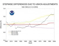
Figure 2. Form of individual corrections applied by NOAA. The black line is the adjustment for time of observation. The red line is for a change in maximum/minimum thermometers used. The yellow line is for changes in station siting. The pale blue line is for filling in missing data from individual station records. The purple line is for UHI effects (this correction is now removed). Link to larger one here.
It is obvious that the only adjustment which reduces the reported warming is UHI which is a linear correction of 0.1F or about 0.06C per century, Figure 2. Note also that the latest indications are that even this minimal UHI adjustment has now been removed in the latest round of revisions to the historical record. To put this in perspective, in my previous article on this site I presented bureau of meteorology data which shows that the UHI impact for Melbourne Australia was 1.5C over the last 40 years equivalent to 3.75C per century and highly non linear.
Compare the treatment of UHI with the adjustments made for measuring stations that have moved out of the city centre, typically to the airport. These show lower temperatures at their new location and the later readings have been adjusted upwards so as to match the earlier readings. The airport readings are lower because the station has moved away from the city UHI. Raising the airport readings, while not adding downwards compensation for UHI, results in an overstatement of the amount of warming. This would seem to be clear evidence of bias. It would be more accurate to lower the earlier city readings to match the airport readings rather than vice versa.
Note also the similarity between the shape of the time of observation adjustment and the claimed global warming record over the 20th century especially the steep rise since 1970. This is even more pronounced if one looks at the total adjustment shown in Figure 3 (again from the same site as Figure 1). As a comparison, a recent version of the claimed 20th century global temperature record downloaded from GISSis shown in Figure 4 (not shown here but can be seen here).
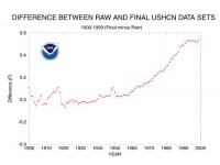
Figure 3. Magnitude of the total correction applied by NOAA - enlarged here.
Since the total corrections for the US look so similar to the claimed temperature anomaly, it begs the questions as to what the raw data looks like without any corrections. Does it show the claimed rapidly accelerating warming trend claimed by the AGW advocates? To determine this I took the raw data from the USHCN graph shown in Figure 1 and plotted this using a 5 year mean (blue trace), matching the smoothing in the NASA GISS profile shown in Figure 4. The result is shown in Figure 5. Please note that while the plot is one that I generated, the data comes directly from the raw data from Figure 1 published by NOAA.
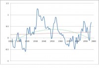
Figure 5 Plot of raw temperature data versus time (from fig 1) 5 point smoothing. Vertical axis degrees Fahrenheit. Red line is a linear trend line. Green line is a 2nd order (parabolic) trend line. Larger image here.
Clearly the shape of this graph bears no similarity at all to the graph shown in Figure 4. The graph does not even remotely correlate to the shape of the CO2 versus time graph. The warming was greatest in the 1930’s before CO2 started to rise rapidly. The rate of rise in 1920, the early 1930’s and the early 1950’s is significantly greater than anything in the last 30 years. Despite the rapid rise in CO2 since 1960, the 1970’s to early 1980’s was the time of the global cooling scare and looking at the graph in Figure 5 one can see why (almost 2F cooling over 50 years).
A linear least squares trend line, created using the Excel trend line function (Red trace) shows a small temperature rise of 0.09C per century which is far less than the rise claimed by AGW supporters and clearly of no concern. However, the data shown in figure 5 bears little if any resemblance to a linear function. One can always fit a linear trend line to any data but that does not mean the fitted line has any significance. For example, if instead I fit a second order trend line (a parabolic) the result is extremely different. That suggests a temperature peak around 1950 with an underlying cooling trend since. Which trend line is the more significant one? If there was really a strong underlying linear rise over the time period it should have shown up in the 2nd order trend line as well. This suggests that it is questionable whether any relevant underlying trend can be determined from the data.
It would appear that the temperature rise profile claimed by the adjusted data is largely if not entirely an artefact arising from the adjustments applied (as shown in Figure 3), not from the experimental data record. In fact, the raw data does not in any way support the AGW theory.
Based on this data, the US temperature data does not correlate with carbon dioxide levels. The warming over the last 3 decades is completely unremarkable and if present at all is significantly less than occurred in the 1930’s. It is questionable whether any long term temperature rise over the 20th century can be inferred from the data but if there is any it is far less than claimed by the AGW proponents.
The corrected data from NOAA has been used as evidence of anthropogenic global warming yet it would appear that the rising trend over the 20th century is largely if not entirely an artefact arising from the “corrections” applied to the experimental data, at least in the US, and is not visible in the uncorrected experimental data record.
This is an extremely serious issue. It is completely unacceptable, and scientifically meaningless, to claim experimental confirmation of a theory when the confirmation arises from the “corrections” to the raw data rather than from the raw data itself. This is even more the case if the organisation carrying out the corrections has published material indicating that it supports the theory under discussion. In any other branch of science that would be treated with profound scepticism if not indeed rejected outright. I believe the same standards should be applied in this case. See full post here.
Jul 03, 2009
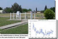
McIntyre on USHCN2’s “warmer” trend treatment of Orland: Detective Mike Hammer and USHCN
By Steve McIntyre
In my last post, I observed that NOAA’s Talking Points applied their new “adjustments” to supposedly prove that NOAA’s negligent administration of the USHCN network did not “matter”.
In order to illustrate the effect of the new methods in this post, I’ll compare the new adjustments (post-TOBS) to the old adjustments (post-TOBS) on a “good” station - Orland CA, a prototype “good” station, discussed at the outset of surfacestations.org, discussed at WUWT here and CA here in early 2007.
The station history for Orland (at CDIAC) says that it has been in its present location for (at least) most of the 20th century and has had minimal changes during that time, other than perhaps time-of-observation (TOBS). The TOBS adjustment is carried forward into USHCN-v2. As I understand it, NOAA’s New Adjustment Method replaces station-history based adjustments for instrumentation changes and station location (the latter formerly done in FILNET).
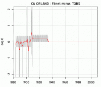
As a benchmark, here is the difference between FILNET (adjusted) and TOBS for Orland in the “old” USHCN. Adjustments in the 20th century are negligible - in keeping with station history information that indicates no changes in location.
“Old” USHCN Adjustments for Station Location and Instrument Changes
Now here is the net adjustment in the “New” USHCN. Two points jump out. Look first at the monthly adjustments at the right hand side. In the “old” method, there weren’t any adjustments to recent data - where metadata did not indicate any relevant change. In the “new” method, there are all sorts of jittery little adjustments. They seem to average out, but why introduce these jitters in the first place? It’s starting to look like a pointless Hansen-esque (ROW-style) adjustment that simply distorts the underlying data.
On a larger scale, the new adjustment noticeably increases the 20th century trend at Orland.
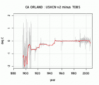
These graphics strongly indicate to me that the effect of the algorithm - regardless of whatever good intentions may underlie it - is that data from lower quality stations is being blended into the presently archived Orland data. I presume that something similar is happening to other “good” stations (though I’ve only examined one example so far.) (Note that Orland is a CRN3 station. However, its excellent continuity makes it a pretty attractive station for benchmarking and visually it doesn’t look a “bad” CRN3 station).
Based on this example, it looks like NOAA’s Talking Points comparison is between the overall average and 70 “adjusted” stations - AFTER the good stations have been adjusted. See post and comments here.
------------------------------
Along this same line, this post on Jennifer Marohasy’s blog by Michael Hammer shows how most of the warming in the USHCN comes from adjustments to the raw data.
In the US, the National Oceanic and Atmospheric Administration (NOAA) collects, analyses and publishes temperature data for the United States. As part of the analysis process, NOAA applies several adjustments to the raw data. If we consider, the below graph, which shows, their plot of the raw data (dark pink) and the adjusted data (pale pink), it is obvious that the adjustments have little impact on data from early in the 20th century but adjust later temperature readings upwards by an increasing amount. This means that the adjustments will create an apparent warming trend over the 20th century. [Click on the above chart for a better larger view, this chart can also be viewed here.
NOAA state that they adjust the raw data for five factors. The magnitude of the adjustments are shown in Figure 2.
Figure 2. Form of individual corrections applied by NOAA. The black line is the adjustment for time of observation. The red line is for a change in maximum/minimum thermometers used. The yellow line is for changes in station siting. The pale blue line is for filling in missing data from individual station records. The purple line is for UHI effects (this correction is now removed). Link to larger one here.
It is obvious that the only adjustment which reduces the reported warming is UHI which is a linear correction of 0.1F or about 0.06C per century, Figure 2. Note also that the latest indications are that even this minimal UHI adjustment has now been removed in the latest round of revisions to the historical record. To put this in perspective, in my previous article on this site I presented bureau of meteorology data which shows that the UHI impact for Melbourne Australia was 1.5C over the last 40 years equivalent to 3.75C per century and highly non linear.
Compare the treatment of UHI with the adjustments made for measuring stations that have moved out of the city centre, typically to the airport. These show lower temperatures at their new location and the later readings have been adjusted upwards so as to match the earlier readings. The airport readings are lower because the station has moved away from the city UHI. Raising the airport readings, while not adding downwards compensation for UHI, results in an overstatement of the amount of warming. This would seem to be clear evidence of bias. It would be more accurate to lower the earlier city readings to match the airport readings rather than vice versa.
Note also the similarity between the shape of the time of observation adjustment and the claimed global warming record over the 20th century especially the steep rise since 1970. This is even more pronounced if one looks at the total adjustment shown in Figure 3 (again from the same site as Figure 1). As a comparison, a recent version of the claimed 20th century global temperature record downloaded from GISSis shown in Figure 4 (not shown here but can be seen here).
Figure 3. Magnitude of the total correction applied by NOAA - enlarged here.
Since the total corrections for the US look so similar to the claimed temperature anomaly, it begs the questions as to what the raw data looks like without any corrections. Does it show the claimed rapidly accelerating warming trend claimed by the AGW advocates? To determine this I took the raw data from the USHCN graph shown in Figure 1 and plotted this using a 5 year mean (blue trace), matching the smoothing in the NASA GISS profile shown in Figure 4. The result is shown in Figure 5. Please note that while the plot is one that I generated, the data comes directly from the raw data from Figure 1 published by NOAA.
Figure 5 Plot of raw temperature data versus time (from fig 1) 5 point smoothing. Vertical axis degrees Fahrenheit. Red line is a linear trend line. Green line is a 2nd order (parabolic) trend line. Larger image here.
Clearly the shape of this graph bears no similarity at all to the graph shown in Figure 4. The graph does not even remotely correlate to the shape of the CO2 versus time graph. The warming was greatest in the 1930’s before CO2 started to rise rapidly. The rate of rise in 1920, the early 1930’s and the early 1950’s is significantly greater than anything in the last 30 years. Despite the rapid rise in CO2 since 1960, the 1970’s to early 1980’s was the time of the global cooling scare and looking at the graph in Figure 5 one can see why (almost 2F cooling over 50 years).
A linear least squares trend line, created using the Excel trend line function (Red trace) shows a small temperature rise of 0.09C per century which is far less than the rise claimed by AGW supporters and clearly of no concern. However, the data shown in figure 5 bears little if any resemblance to a linear function. One can always fit a linear trend line to any data but that does not mean the fitted line has any significance. For example, if instead I fit a second order trend line (a parabolic) the result is extremely different. That suggests a temperature peak around 1950 with an underlying cooling trend since. Which trend line is the more significant one? If there was really a strong underlying linear rise over the time period it should have shown up in the 2nd order trend line as well. This suggests that it is questionable whether any relevant underlying trend can be determined from the data.
It would appear that the temperature rise profile claimed by the adjusted data is largely if not entirely an artefact arising from the adjustments applied (as shown in Figure 3), not from the experimental data record. In fact, the raw data does not in any way support the AGW theory.
Based on this data, the US temperature data does not correlate with carbon dioxide levels. The warming over the last 3 decades is completely unremarkable and if present at all is significantly less than occurred in the 1930’s. It is questionable whether any long term temperature rise over the 20th century can be inferred from the data but if there is any it is far less than claimed by the AGW proponents.
The corrected data from NOAA has been used as evidence of anthropogenic global warming yet it would appear that the rising trend over the 20th century is largely if not entirely an artefact arising from the “corrections” applied to the experimental data, at least in the US, and is not visible in the uncorrected experimental data record.
This is an extremely serious issue. It is completely unacceptable, and scientifically meaningless, to claim experimental confirmation of a theory when the confirmation arises from the “corrections” to the raw data rather than from the raw data itself. This is even more the case if the organisation carrying out the corrections has published material indicating that it supports the theory under discussion. In any other branch of science that would be treated with profound scepticism if not indeed rejected outright. I believe the same standards should be applied in this case. See full post here.
Jul 03, 2009
The Wong Fielding Meeting on Global Warming - Documents
By Joanne Nova
Introductory comments from Dr. Bob Carter.
You will have heard on the news over the last 3 weeks of the activities of Senator Steve Fielding in Australia. Steve is an independent cross-bench senator who holds a casting vote over the passage of the Australian ETS (termed the Carbon Pollution Reduction Scheme).
After attending the Heartland-3 climate conference in Washington in early June this year, Steve returned to Australia and asked Climate Minister Penny Wong three simple questions about climate change. The Minister replied, first in a meeting at which her Chief Scientist (Penny Sackett) and departmental science adviser (Will Steffen) presented a briefing paper, and secondly in writing.
Senator Fielding then asked his advisory scientists - Bob Carter, David Evans, Stewart Franks and Bill Kinimonth - to perform an audit of the Minister’s replies to his questions. Copies of Senator Fielding’s original questions, Minister Wong’s written reply, and other papers relevant to the matter are available for download from Joanne Nove’s blog (below).
The Due Diligence Paper has been released publicly by Senator Fielding’s office today (July 3; together with the two covering press releases). It shows, first, that the Minister and her Department have largely been unable to answer the questions that they were asked. And, second, that the Australian Department of Climate Change has little capacity to assess the science of global warming in an expert, knowledgeable and independent way.
We believe that this is the first time recently that a member of a western parliament has released a public document that makes an independent science assessment of the danger of human-caused global warming (as promulgated by the IPCC), thereby demonstrating (i) the lack of empirical evidence that carbon dioxide emissions are damaging to the environment, and (ii) that ETS are unnecessary.
By Joanne Nova
These are the documents arising from the meeting between Senator Fielding and the Minister for the Climate Change and Water, Penny Wong, on 15 June 2009.
Senator Fielding was accompanied by four independent scientists: Bob Carter, David Evans, Stewart Franks, and William Kininmonth. Minister Wong was accompanied by the Chief Scientist Penny Sackett and by Professor Will Steffen.
Official Documents
1. Fielding’s Questions to Wong, June 15
2. Fielding’s Note to Wong on the NIPCC Report, June 15
3. Sackett-Steffen Briefing Paper (delivered for Wong at meeting), June 15
4. Wong-Steffen Response to Questions, June 18
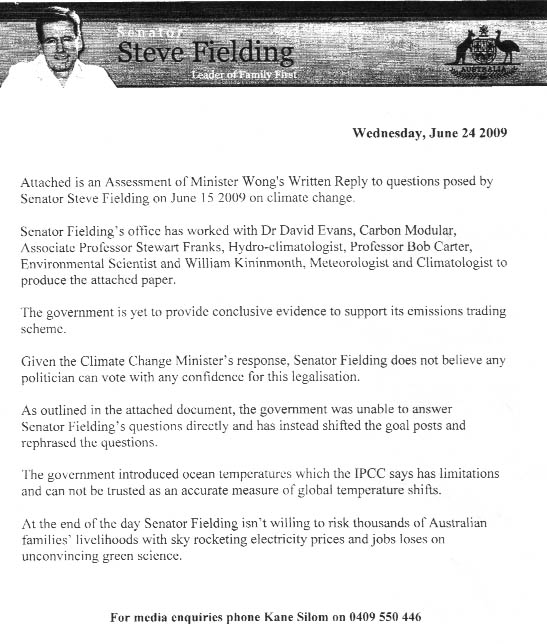
5. Fielding Press Release, June 24
6. Fielding Press Release, July 3
7. Carter-Evans-Franks-Kininmonth Due Diligence Report on Wong, July 3
8. Carter-Evans-Franks-Kininmonth Press Release, July 3
Note that one relevant paper has not been released into the public domain. It is the Minister’s personal letter to Senator Fielding on June 18th, which accompanied her written departmental replies to his questions. A number of the points made in that letter are analysed in Section D of the Due Diligence Report.
Unofficial Documents
Account of the meeting by David Evans
Article in The Australian newspaper, by the four independent scientists
Senator Fielding’s web page on climate change, with his position, documents, blog articles, and news articles
Correspondence between William Kininmonth and Matthew England, plus commentary by Joanne
The change in alarmist direction that became evident at the meeting and in their new Synthesis Report
Overview of the four temperature datasets for Senator Fielding, by David Evans
Model Hindcasts are not evidence, but worthless, by David Evans
Jul 02, 2009
The Suspicious Science Behind Man-Made Global Warming
By Dr. James Anderson, Minyanville
Paul Krugman, the Nobel Prize-winning economist, had an op-ed in Monday’s New York Times in which he called anyone who’s skeptical of man-made global warming a “traitor to the Earth.” Now, I don’t have a PhD in Economics (although I do have one in another field), nor do I have a Nobel Prize, but that accusation seems a bit over the top. Perhaps it’s just another example of the growing societal acrimony frequently discussed on Minyanville.
I’d like to take a look at the evidence for global warming resulting from increased CO2 levels in the atmosphere: The argument is that more infrared radiation released by the Earth is captured given the higher concentration of CO2 in the air, thereby warming the planet. However, if you’re looking for scientifically rigorous experiments linking CO2 to increased temperatures, I have bad news for you: It doesn’t exist.
What we have are computer models showing that increased CO2 levels will lead to catastrophic increases in global temperatures; an increase of as little as 10 degrees Fahrenheit will cause a lot of ice will melt, the sea level to rise, and Newfoundland to resemble Bermuda. But that’s the model talking.
Can any model accurately capture the complexities of the Earth’s atmosphere? There are certainly many sophisticated ones out there. Happily, most of them use actual physical experiments to verify their underlying assumptions. However, until the “Flux Capacitor” from Back to the Future gets built, any climate model will need decades to verify its assumptions using real data.
Climate simply refers to one day of weather after another. Global-warming true believers, let me ask you the following question: Do you view weather forecast projections for 2 weeks from today with the same certainty that you do a computer model that purports to predict the weather 100 years from now? If not, why not? After all, they’re both based on computer models. If your neighbor told you he were getting a tent for his daughter’s wedding reception 2 weeks from now, and you told him not to bother, because a computer model predicted sunny weather, do you think he’d take you seriously?
The key to good science—not good politics—is understanding the scientific method. Richard Feynmann, the Nobel Prize-winning physicist, put it this way: “It doesn’t matter how beautiful your theory is; it doesn’t matter how smart you are. If it doesn’t agree with experiment, it’s wrong.”
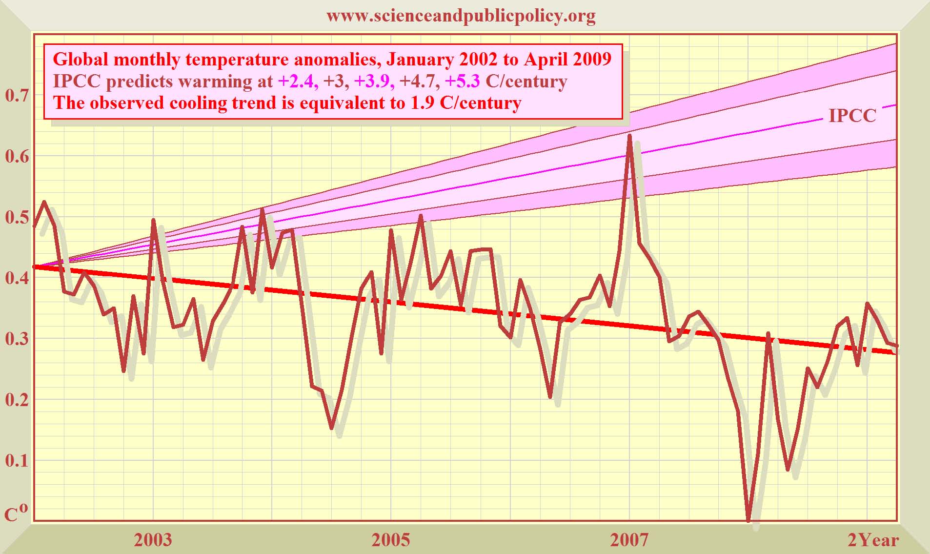
Since we can’t look 50 years into the future, let’s go back and look at the actual climate forecasts from 6 to 7 years ago, and compare the global temperature forecasts to the actual observed temperatures.
Here’s some science that no one with a vested political or financial interest in climate change would want you to know: The warmest year since 1934 was 1998, at the height of the strongest El Nino on record. The gold standard for CO2 measurement is taken at Mauna Loa Observatory in Hawaii. In 1998, the observatory recorded 366 parts per million (ppm) of CO2 in the atmosphere; it steadily rose to 386 ppm in 2008. In the meantime, the earth has cooled.
If we go back to climate models from, say, 2002, what did they predict during the past 7 years as CO2 was steadily rising?
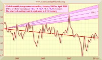
Graph courtesy of SPPI enlarged here.
As you can see, the IPCC models—the ones blessed by the UN—predicted that global temperatures would be steadily warming, but instead they’ve been cooling. Let’s recall what Feynmann said: If the data don’t agree with the theory, the theory’s wrong—regardless of a widespread public desire to blame Exxon (XOM), or Chevron (CVX), or Hummers (GM) for global warming.
The observed temperature data don’t match what the model predicts. In physics (my field), we’d look at both the experiment and the data to see whether there was something wrong with the experiment’s design, or whether the data were right and the theory wrong. Either way, we’d step back and reevaluate everything. What we certainly wouldn’t do is cram 300 pages of amendments through Congress at 3:00 a.m. and force a vote the next day.
Back in March, 2007, Al Gore told Congress that “the science is settled.” Don’t do any more research, don’t question my judgment, “The science is settled.’ The person who probably heard that first was Galileo Galilei: “The science is settled. The Sun revolves around the Earth, not vice versa. You’re hereby sentenced to house arrest until you recant your heretical views.” Poor Galileo, the man Albert Einstein called “the father of modern science,” spent the rest of his life under house arrest. Read much more here.
|

