Jan 01, 2009
Global Warming? New Year Ushers in New Snowfall Records
By P.J. Gladnick, Newsbusters
As soon as your humble correspondent flipped on the TV set this New Year morning, he heard an MSNBC report about record levels of snowfall that just hit the Pacific Northwest. Checking around the web, it turns out that other parts of the country were also hit with record levels of snowfall. Here are a few of the reports starting with this one in the Green Bay Press Gazette: Green Bay ended the month with 45.8 inches of snowfall, the most of any December on record.
It buried the previous record of 36.4 inches, set in December 1887, but fell 2.6 inches short of matching the snowiest month of all time for Green Bay. That record goes to March 1888, with 48.2 inches, which helped the winter of 1887-88 become the snowiest winter in Green Bay history at 147.7 inches total.
And in the more liberal part of Wisconsin, Madison, the snowfall records are already tumbling as reported in the Wisonsin State Journal (data updated to December 31). The 44.7 inches already in November and December have virtually reached the 45 inches that normally falls in any given winter in these parts, with the brunt of winter (4 months) still to come. The record snowfall in December is now at 40.4 inches, breaking the previous December mark of 35 inches set in 2000 as well as the previous all month record mark of 37 inches that fell in February 1994.
I loved the movie Fargo and in that North Dakota city snowfall records also fell as you can see in this report: Fargo’s December snowfall total as of end of the year was 33.5 inches, which broke the previous record of 29.2 inches set in December 1927, according to the weather service. Grand Forks, ND also set a record with 30.1 inches of snowfall this December, compared to the previous record of 27.6 inches set back in 1918. Bismarck, ND, also set a snowfall record with 33.3 for the month (45.8 so far this season).
It will be interesting to see what the Global Warming Alarmists of the Boston Globe will make of this story which just appeared in their own newspaper yesterday: SPOKANE, Wash. - Spokane residents were trying to dig out yesterday after a record-breaking month of snow (an amazing 61.5 inches) collapsed roofs and clogged streets.
And how was the weather at midnight as the New Year was marked by the famous ball drop in Times Square? The New York Post describes the scene: In a fitting end to a miserable year that saw an economic meltdown, Wall Street’s collapse and massive job losses, bitter cold descended on New York to usher out 2008. Hundreds of thousands of bundled-up celebrants descended on the Crossroads of the World - huddled in blankets and shielded under umbrellas. Driving snow pounded many of the early-bird revelers throughout yesterday, and by midnight, the mercury had plummeted to 18 degrees. Howling wind gusts of up to 40 mph made it feel below zero at times.
So the New Year has been heralded in by record snowfall and bitterly cold temperatures but will the Global Warming Alarmists in the media notice? And will some enterprising reporter out there ask Al Gore how he can reconcile his Global Warming predictions with the incredibly cold weather we’ve been having recently including snowstorms in Las Vegas and snowfall in New Orleans?
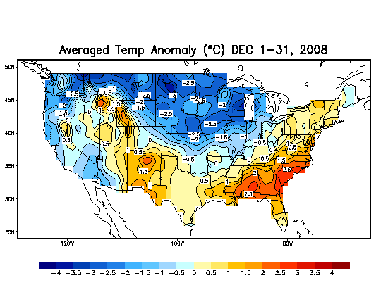
Icecap Note; here is the preliminary temperature anomaly map for December 2008 (source: NOAA CPC)
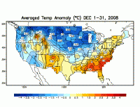
See larger image here
Dec 30, 2008
Don Easterbrook’s AGU Paper on Potential Global Cooling
By Don Easterbrook on WattsUpWithThat
Global, cyclic, decadal, climate patterns can be traced over the past millennium in glacier fluctuations, oxygen isotope ratios in ice cores, sea surface temperatures, and historic observations. The recurring climate cycles clearly show that natural climatic warming and cooling have occurred many times, long before increases in anthropogenic atmospheric CO2 levels. The Medieval Warm Period and Little Ice Age are well known examples of such climate changes, but in addition, at least 23 periods of climatic warming and cooling have occurred in the past 500 years. Each period of warming or cooling lasted about 25-30 years (average 27 years). Two cycles of global warming and two of global cooling have occurred during the past century, and the global cooling that has occurred since 1998 is exactly in phase with the long term pattern. Global cooling occurred from 1880 to ~1915; global warming occurred from ~1915 to ~1945; global cooling occurred from ~1945-1977;, global warming occurred from 1977 to 1998; and global cooling has occurred since 1998. All of these global climate changes show exceptionally good correlation with solar variation since the Little Ice Age 400 years ago.
The IPCC predicted global warming of 0.6C (1F) by 2011 and 1.2C (2F) by 2038, whereas Easterbrook (2001) predicted the beginning of global cooling by 2007 (± 3-5 yrs) and cooling of about 0.3-0.5C until ~2035. The predicted cooling seems to have already begun. Recent measurements of global temperatures suggest a gradual cooling trend since 1998 and 2007-2008 was a year of sharp global cooling. The cooling trend will likely continue as the sun enters a cycle of lower irradiance and the Pacific Ocean changed from its warm mode to its cool mode.
Comparisons of historic global climate warming and cooling, glacial fluctuations, changes in warm/cool mode of the Pacific Decadal Oscillation (PDO) and the Atlantic Multidecadal Oscillation (AMO), and sun spot activity over the past century show strong correlations and provide a solid data base for future climate change projections. The announcement by NASA that the Pacific Decadal Oscillation (PDO) had shifted to its cool phase is right on schedule as predicted by past climate and PDO changes (Easterbrook, 2001, 2006, 2007) and coincides with recent solar variations. The PDO typically lasts 25-30 years, virtually assuring several decades of global cooling. The IPCC predictions of global temperatures 1F warmer by 2011, 2F warmer by 2038, and 10F by 2100 stand little chance of being correct. “Global warming” (i.e., the warming since 1977) is over!
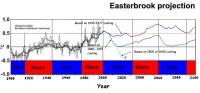
See larger image here
The good news is that global warming (i.e., the 1977-1998 warming) is over and atmospheric CO2 is not a vital issue. The bad news is that cold conditions kill more people than warm conditions, so we are in for bigger problems than we might have experienced if global warming had continued. Mortality data from 1979-2002 death certificate records show twice as many deaths directly from extreme cold than for deaths from extreme heat, 8 times as many deaths as those from floods, and 30 times as many as from hurricanes. The number of deaths indirectly related to cold is many times worse.
Depending on how cold the present 30-year cooling period gets, in addition to the higher death rates, we will have to contend with diminished growing seasons and increasing crop failures with food shortages in third world countries, increasing energy demands, changing environments, increasing medical costs from diseases (especially flu), increasing transportation costs and interruptions, and many other ramifications associated with colder climate. The degree to which we may be prepared to cope with these problems may be significantly affected by how much money we waste chasing the CO2 fantasy. Read more here.
Dec 29, 2008
Met Office Warns of Siberian Blast and Freezing Weather
By Paul Simons, UK TimesOnLine
It’s time to get out the thermal underwear and thickest pullovers - Britain is set for shockingly cold weather for at least the next couple of weeks. After a glorious Christmas, with not a hint of a snowflake, temperatures have been slipping steadily downwards, with minus 11C (12F) recorded in Aviemore, in the Highlands, on Saturday night.
The plunge into a Siberian blast of cold will worsen in the coming week as raw easterlies freeze the country. “This coming week, maximum daytime temperatures will be between 2C (36F) and 4C (39F) but temperatures at night could be well below zero for many places,” said Stephen Holman, forecaster at the Met Office.
The freezing conditions are being swept down from a strong high-pressure system anchored close to Scandinavia. Like a boulder firmly stuck in a river, this anticyclone is refusing to budge and sending our usual wet and windy winter weather on a wide detour, a system known as a blocking weather pattern.
Although it will feel bitterly cold, conditions will also largely be dry, at least for the next few days, and no significant snowfall is expected, although northern and eastern regions could experience some snow.
Exactly how cold it will become largely depends on where the high pressure sits and how much cloud it drags off the North Sea. And cloudy skies are needed, because they act like a duvet cover, helping to prevent some of the heat loss from the ground. If the nights turn clear and winds are light, though, temperatures could plummet as low as minus 10C (14F) even in the South of England in the next fortnight.
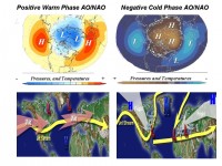
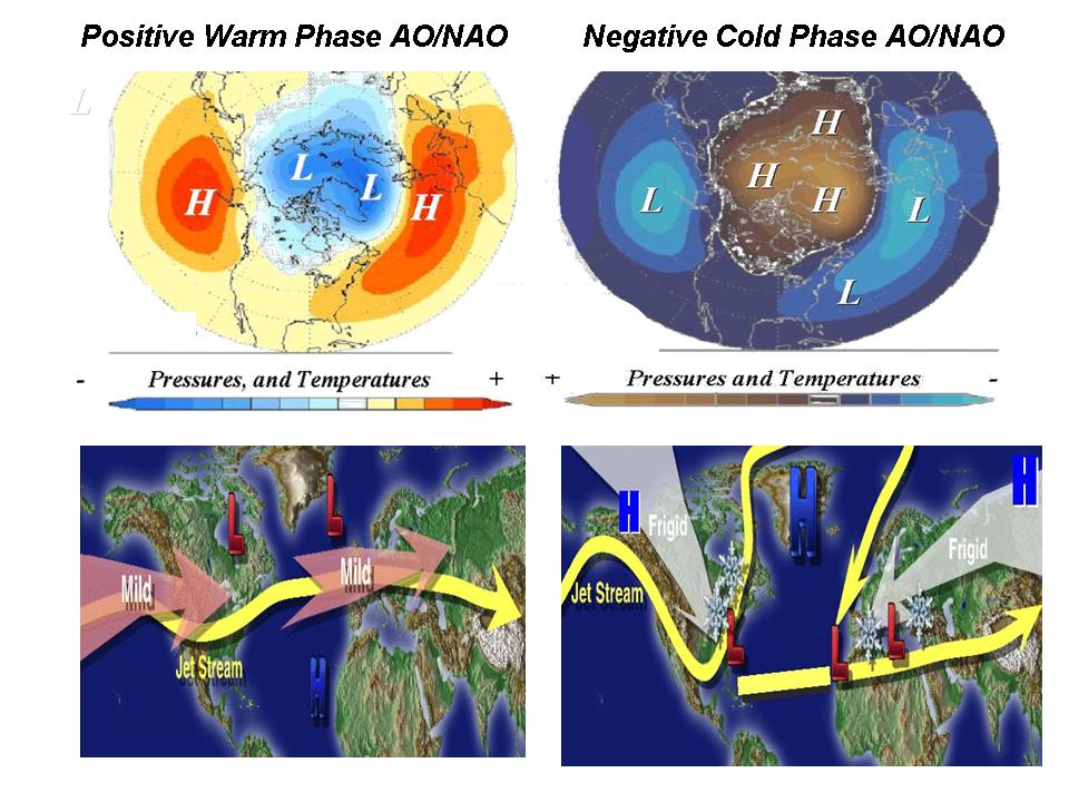
In winter, low pressure tends to dominate over Iceland and high pressure to the south, over the Azores. These two pressure systems dance in tune with each other and drive our winter weather, in what is known as the North Atlantic Oscillation (NAO). When the Icelandic low and Azores high are strong, they steer wet and mild weather over the UK; but when they slacken off in a negative phase, that turns the UK bitterly cold. At present the NAO is turning negative, sending a powerful signal that the weather is set to continue cold.
See larger image here.
How bad could this winter sink? The weather maps are a chilling reminder of some our most savage winters, such as the notorious 1962-63 winter, the coldest for 180 years. This was when the sea froze around the coast of southeast England and crops were dug out of frozen ground with pneumatic drills and blizzards paralysed the nation.
Even if next month is freezing, the Met’s long-range forecast predicts that the winter will melt away into warmer conditions in February. (Icecap Note: The Met Office said that about January during the cold in November and December) Read more here.
Dec 25, 2008
Study: Global Warming Will Challenge Ski Industry
By Bill Scanlon, Rocky Mountain News
Global warming may challenge lower-altitude ski areas like Vail - shown here last week - to make more snow and cut higher runs. Colorado’s ski areas will have to carve runs higher up the mountains and triple their snowmaking if they are to co-exist with global warming over the coming decades, a new study says. That extra snowmaking will require a lot more water at a time when it is very expensive to buy senior water rights, says the study presented today to the American Geophysical Union conference in San Francisco. And it would have to come from a distance away, because any diversion close by would harm wildlife habitats.
Gondolas will have to be revamped - to take skiers from skimpy snow at the bottom of the mountain high up to where there is a permanent snowpack. Aspen Mountain’s snowpack line - the elevation at which winter-season snowpack can be assured - will be 2,400 vertical feet higher up by the end of the century. “Ski resort operators are really scrambling,” co-author Mark Williams, a geography professor at the University of Colorado, said. “The bottom line is that in order to survive, these ski areas will need to find the necessary water wherever they can and hold it in storage to satisfy future snowmaking needs.”
One sliver of good news is that Aspen Mountain looks like it will fare quite a bit better than Park City, Utah, which could have no snowpack at all at its base by the end of the century. Williams and co-author Brian Lazar of Boulder took detailed looks at Aspen Mountain and Park City, but said their findings on Aspen would apply to most ski areas in Colorado, as well.
The authors painted a future scenario for the two ski areas - for the years 2030, 2075 and 2100. And they looked at three projections - optimistic, in which there is an immediate reduction in CO2 emissions worldwide; mid-line, in which the reduction comes a little slower; and business-as-usual, in which there is no reduction in total emissions. Unhappily, the past five years, total worldwide carbon-dioxide emissions have exceeded even the pessimistic business-as-usual models. The business-as-usual scenario will cause average temperatures to rise by about 4 degrees in Aspen by the time today’s toddlers have graduated from college, Williams said.
The new study was sponsored by Aspen Mountain and the Park City Mountain Resort said Lazar. Two nonprofits - the Aspen Global Change Institute and the Park City Foundation - are working with the ski areas to better understand environmental climate change. “Ski industry officials know that warming is real, and that small changes in climate have substantial effects on ski areas,” said Williams, also a fellow at CU-Boulders Institute of Arctic and Alpine research. One sliver of good news for Colorado is that its resorts likely won’t suffer as dramatically as Park City in Utah, which likely will no snowpack at its base by 2100. Smaller ski areas in Pennsylvania, West Virginia, Oregon, Washington and California’s Sierra Nevada, could be forced out of business in the coming decades as air temperatures continue to warm, they said.
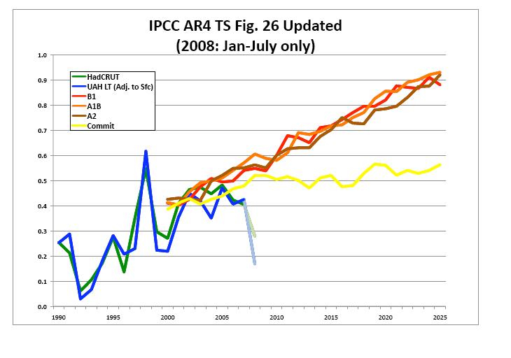
Read this out of touch with reality story here. Talk about cognitive dissonance! Last year record snows fell throughout North America including Colorado- 8 Colorado ski resorts set new records: Snowmass, (450 inches), Beaver Creek (430 inches), Crested Butte (422 inches), Monarch Mountain (482 inches), Powderhorn (320 inches), Silverton (550 inches), Steamboat (489 inches) and Telluride (353 inches). This year has been very snowy in the Northwest and Rockies and will again be a banner year. In fact today I received an email from a father of a man who runs the race department at Beaver Creek who reports 12 feet of snow on the ground, a new record. This will be typical of what we can expect in the decades ahead with a switch back to a cold PDO and more La Ninas and a quiet sun. The authors again rely on faulty tinkertoy models that have failed miserably to capture trends (reds and browns IPCC model scenarios and yellow their solution with CO2 held in check, blue and green is actual temperature).

See larger image here
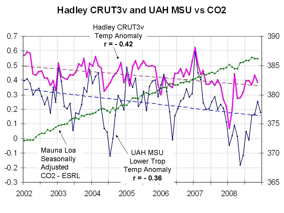
Furthermore the claim that emissions have increase may be true but the background CO2 levels continue the same slow rise they have since measurements began while global temperatures FALL (here we plot the monthly Hadley CRU Temperature (V3) and UAH MSU temps and the seasonally adjusted ESRL Mauna Loa CO2).
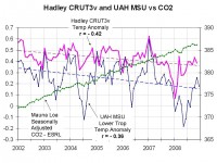
See large image here
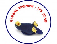
One of our Canadian friends buried in snow noted “Fortunately, I think they will find that the public is not fooled, they know a dead parrot when they see it. I loved this line so much (from Monty Python) I made a sticker.”
See larger image here
Dec 24, 2008
Minus 60 (deg C)
By Steve McIntyre, Climate Audit
Climate Audit, December 18, 2008
One of the interesting by-products of the GISS screw-up in October was that we learned the names and locations of quite a few Siberian weather stations - that are glaring “hot spots” on temperature anomaly maps. However, most of these places are among the coldest places on earth.
One of them was Verhojansk, about which Anthony Watts had an interesting post last week; it was one of the screwed up NOAA-Hansen sites. It vies for the title of coldest place (in the Northern Hemisphere) with nearby Ojmjakon. (the place where the lowest-ever temperature in the Northern hemisphere was recorded - Verkhoyansk with a record of minus 67.8 degrees Celsius (minus 90 degrees Fahrenheit) and Oymyakon with a minimum of minus 67.7 degrees Celsius (minus 89.9 degrees Fahrenheit).
I’ve taken to occasionally checking on these sites to see how they’re doing and there’s something interesting to watch for over the next few days - the sort of thing that might appeal to people who liked following the summer ice melt. Daily weather information for Ojkjakon is online here
Anyway, in the GHCND history for Ojmjakon online here , there hasn’t been a minus 60 deg C day in December for 15 years and only one in the past 25 years. There has been only one December temperature at Ojmjakon below 62.5 in the GHCND archive (since 1943) - a reading of -62.8 in 1984.
But according to the forecasts here, a low of minus 60 is forecast tonight and minus 63 tomorrow. (Icecap Note: It reached -60C, -76F on the 20th and 22nd).
The GHCND daily records are maintained consistently up to 2000, but archiving of daily data became very sporadic following the IPCC TAR report. Over the past week, GHCN-D has not managed to record temperatures that were readily available online.
Want to bet the western Russia stations are being recorded. They have been sitting under a ridge and exhibiting warmer than normal readings.
|

