

NOAA NCDC
NOAA’s State of the Climate report for the winter season (December through February) anthe month of February, state that temperatures were below normal for the contiguous United States. The winter season was wetter than normal; however precipitation in February alone was slightly below average.
Based on data going back to 1895, the monthly analyses, prepared by scientists at NOAA’s National Climatic Data Center in Asheville, N.C., are part of the climate services that NOAA provides to businesses, communities and governments so they may make informed decisions to safeguard their social and economic well-being.
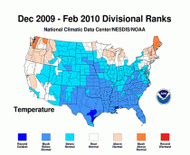
U.S. Temperature Highlights
High resolution (Credit: NOAA)
For the winter season, 63 (appears based on number of divisions not area) percent of the country experienced below normal temperatures. In contrast to this national trend, Maine experienced the third warmest winter. February’s average temperature was 32.4 degrees F, which is 2.2 degrees below the long-term average.
Cold air in the wake of several reinforcing Arctic air masses dominated much of the United States during February, creating temperatures that were much-below average in the Deep South and below average in the Plains and mid-Atlantic states. Both the South and Southeast climate regions experienced their seventh coldest February on record. Meanwhile, warmer-than-average temperatures dominated the Northwest and Northeast climate regions. Florida had its fourth coldest February, Louisiana its fifth coldest, and Alabama, Georgia and Texas each had their sixth coldest. It was the seventh coldest February in Arkansas, while both Mississippi and South Carolina experienced their eighth coldest.
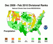
U.S. Precipitation Highlights
High resolution (Credit: NOAA)
Precipitation for the winter season was above average while it averaged slightly below the long term mean for the month of February. The season-long wet spell was notable for the Southeast, as Alabama, Florida, Georgia, and North Carolina each had their eighth wettest winter. Precipitation was also much above normal for South Dakota, Virginia, New Jersey and Maryland. Wyoming and Idaho experienced their eighth and ninth driest winters, respectively.
Regionally, the active weather pattern in the South, Southwest, and Northeast created above normal precipitation for the month. The Northwest, West North Central, East North Central, and Central climate regions each had below-normal February precipitation. On the state level, New Mexico experienced its seventh wettest February on record. Conversely, Idaho had its seventh driest, and Wyoming its eighth driest.
Other Highlights
Major snowstorms on Feb. 4-7 and Feb. 9-11 plagued the Atlantic states. These storms ranked as Category Three (major) and Two (significant) storms respectively on the Northeast Snow Impacts Scale (NESIS). Combined and treated as one storm, they would become only the third Category Five (extreme) storm (the most extreme category) of the NESIS record. A third storm, also ranking as a Category Three on the NESIS scale, occurred across southern New England on Feb. 23-28. February 2010 is the first month during the NESIS period of record, since 1956, to place three storms of Category Two or greater.
Several seasonal snowfall records were set: (previous record)
Baltimore: 79.9 inches (62.5 inches, 1995-96)
Washington (Dulles): 72.8 inches (61.9 inches, 1995-96)
Washington (National): 55.9 inches (54.4 inches, 1898-1899)
Wilmington, Del.: 66.7 inches (55.9 inches, 1995-96)
Philadelphia: 71.6 inches (65.5 inches, 1995-96)
Atlantic City, N.J.: 49.9 inches (46.9 inches, 1966-67)
In several eastern cities, February was the snowiest month on record: (previous record)
Washington (Dulles): 46.1 inches (34.9 inches, February 2003)
Central Park, N.Y.: 36.9 inches (30.5 inches, March 1896)
Pittsburgh: 48.7 inches (40.2 inches, January 1978)
Background information on this winter’s snowstorms and the links to climate change is available online here.
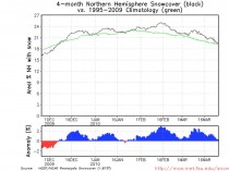
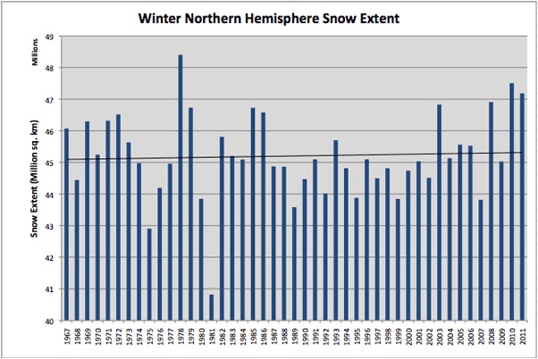
Icecap additonal notes: Dallas Fort Worth came within 0.5 inches of their 1977/78 record and Des Moines is within 3 inches of an all time record set in 1911/12. Note the consistent above normal snowcover through the winter. It ended up second snowiest since records started in 1967.
Enlarged here.
Enlarged here.
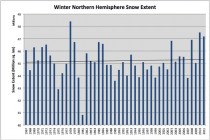
Above is the top 12 winters for average snowcover. 2009/10 trailed only 1977/78 and finished ahead of 2007/08 and 2002/03 (courtesy Rutger’s snowlab).
See also here, where the Russian winter ranked perhaps as the coldest ever with very heavy snows. See here an excellent summary of the winter of 2009-10 in Europe, storm by atorm.