|
Mar 18, 2008
Winds of Change
By Maggie Thauerskold, Helsingborg, Sweden
If you follow the climate debate you have probably noticed a slight change. What was formerly referred to as “global warming” is now called “climate change”. Perhaps to safeguard the case against a sudden 180-degree swing. This record cold winter has paralyzed many parts of the world despite the ever-growing amount of greenhouse gases billowing out from India and China.
Even though there is some uneasiness among the alarmists, they can’t just put down arms and acknowledge defeat. Too much money has already been invested. Too many jobs and reputations are on the line. So they add some wrinkles to the story and hope nobody will react. It’s like the story about the boiling frog. By making small gradual adjustments the alarmists hope change will be imperceptible.
Take for example John Tierney in The New York Times. It looks like someone at the NYT has finally caught on to the hoax but won’t admit it. So instead they try to gently slip in the truth.
All the faithful are of course a little worried. How can this super-cold winter happen? What is wrong with the climate change? Around the world, the modeling teams are sweating to adjust their calculations. At the same time other scientists, such as Ferenc Miskolczi, discover that “greenhouse warming” may be mathematically impossible. In short, the warming models assume that the atmosphere is infinitely thick. If on the other hand, you assume the atmosphere is about 100 km thick (about 65 miles) - which has the big advantage of being true, - the greenhouse effect disappears! Oops, no more global warming. What happens once this farce is finally exposed? Whose heads will roll? Read Maggie’s blog here.
Icecap Note: Of course it was not a record cold winter for the globe though it was for parts of the globe and the greenhouse effect doesn’t disappear just the enhanced greenhouse model warming.
Mar 18, 2008
CO2 and Global Warming
Dr. Richard Lindzen in Ecoworld
Climate models forecast increasing temperatures on earth because of increasing levels of atmospheric CO2, but observational data appears to contradict this claim.
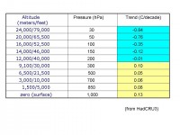
Subsequent to publishing the feature “The Fluid Envelope - A Case Against Climate Alarm” by Dr. Richard Lindzen, we received an email from a science journalist questioning one of the central assertions in Lindzen’s report. The writer wanted to know on what basis Dr. Lindzen was claiming there has been no significant warming in the last 10+ years. In response, Lindzen emailed the following table, showing temperature trends for the last 27 years. This data is based on global (including over the ocean) average temperature readings per year, per altitude, as reported by the U.K.’s Hadley Climatic Research Unit:

See larger table here
As the data indicates, over the past two decades, temperatures have actually declined in the upper troposphere, even though there has been some minor upward trends in temperature at sea level and lower altitudes. This completely contradicts conventional global warming models. As Dr. Lindzen explained in his follow up email:
“I used this data to show that the trend at 300 hPa was not about 2.5 x the surface trend which is what greenhouse warming [models] requires.” Apparently climate models that predict global warming ala increasing levels of atmospheric CO2 assume increasing temperature trends in the troposphere, where CO2 concentrates, and the reality is the troposphere is not getting hotter, it is getting cooler.
Before we radically rearrange the political economy of the world because some scientists claim anthropogenic CO2 is the cause of climate change, it might be worthwhile for anyone taking a position on the topic to consider whether or not this is indeed “well settled science.”
Mar 14, 2008
NOAA: Coldest Winter Since 2000/01 for the US, Globe
NOAA
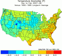
The average temperature across both the contiguous U.S. and the globe during climatological winter (December 2007-February 2008) was the coolest since 2001, according to scientists at NOAA’s National Climatic Data Center in Asheville, N.C. In the contiguous United States, the average winter temperature was 33.2F (0.6C), which was 0.2F (0.1C) above the 20th century average - yet still ranks as the coolest since 2001. It was the 54th coolest winter out of 114 years since national records began in 1895. It was warmest in the east and south and coldest in the west and central states.

See larger image here
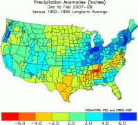
In terms of winter precipitation, Pacific storms, bringing heavy precipitation to large parts of the West, produced high snowpack that will provide welcome runoff this spring. During January alone, 170 inches of snow fell at the Alta ski area near Salt Lake City, Utah, more than twice the normal amount for the month, eclipsing the previous record of 168 inches that fell in 1967. At the end of February, seasonal precipitation for the 2008 Water Year, which began on October 1, 2007, was well above average over much of the West. Mountain snowpack exceeded 150 percent of average in large parts of Colorado, New Mexico, Arizona, and Oregon at the end of February. Spring run-off from the above average snowpack in the West is expected to be beneficial in drought plagued areas.

See larger image here
Record February precipitation in the Northeast helped make the winter the fifth wettest on record for the region. New York had its wettest winter, while Pennsylvania, Connecticut, Vermont, and Colorado to the West, had their second wettest. Snowfall was above normal in northern New England, where some locations posted all-time record winter (December to February) snow totals. Concord, N.H., received 100.1 inches, which was 22.1 inches above the previous record set during the winter of 1886-87. Burlington, Vt., received 103.2 inches, which was 6.3 inches above the previous record set during the winter of 1970-71.
See full release here. Note areas of the Midwest also saw record snow including as we have reported Madison, Wisconsin and also Green Bay. See the Green Bay story here.
Mar 12, 2008
Is Climate Sensitive to Solar Variability?
By Nicola Scafetta and Bruce J. West
The causes of global warming-the increase of approximately 0.8plus or minus 0.1C in the average global temperature near Earth’s surface since 1900-are not as apparent as some recent scientific publications and the popular media indicate. We contend that the changes in Earth’s average surface temperature are directly linked to two distinctly different aspects of the Sun’s dynamics: the short-term statistical fluctuations in the Sun’s irradiance and the longer-term solar cycles. This argument for directly linking the Sun’s dynamics to the response of Earth’s climate is based on our research and augments the interpretation of the causes of global warming presented in the United Nations 2007 Intergovernmental Panel on Climate Change (IPCC) report.
Thus the average global temperature record presents secular patterns of 22- and 11-year cycles and a short timescale fluctuation signature (with apparent inverse power-law statistics), both of which appear to be induced by solar dynamics. The same patterns are poorly reproduced by present-day GCMs and are dismissively interpreted as internal variability (noise) of climate. The nonequilibrium thermodynamic models we used suggest that the Sun is influencing climate significantly more than the IPCC report claims. If climate is as sensitive to solar changes as the above phenomenological findings suggest, the current anthropogenic contribution
to global warming is significantly overestimated. We estimate that the Sun could account for as much as 69% of the increase in Earth’s average temperature, depending on the TSI reconstruction used. Furthermore, if the Sun does cool off, as some solar forecasts predict will happen over the next few decades, that cooling could stabilize Earth’s climate and avoid the catastrophic consequences predicted in the IPCC report. Read the full opinion here.

Nicola Scafetta is a research associate in the Duke University physics department. Bruce West is chief scientist in the mathematical and information science directorate, US Army Research Office, in Research Triangle Park, North Carolina.
Mar 11, 2008
Canada Again Blasted by Latest Weekend Storm
By Dr. Madhav, Khandekhar, retired Environment Canada Meteorologist
The March 8 2008 winter storm was perhaps 8th or 9th storm to hit the greater Toronto area since December 10 2007. This latest storm was a mammoth storm, a blizzard by definition with wind gusts close to 100 km/hr at times and wind chill values in the range of -20C ( ~-5F). Total snow fall out of this storm: 15-25 cm: more snow elsewhere, for example Ottawa ( Canada’s Capital city) received almost 50 cm of snow between Friday & Saturday, as did St. Catherines, a town of over 150K near Niagara Falls.
For the greater Toronto area, the total seasonal snow accumultaion so far: 195 cm ( Normal ~115 Cm), record snow fall in 1938-39 winter, 207 cm; with a few more weeks of below freezing temperatures to prevail, it is likely Toronto will surpass the all-time snow accumulation of 207 cm set in 1938-39
Day After Storm: Lots of snow in streets every where, very little has melted away as temperature continues well below normal, Monday ( March 10) morning temp is -14C in Markham (northeast of Toronto Downtown) and about -12C in Downtown Toronto (urban impact)
Elsewhere in the Canadian Maritimes: Almost record-breaking snow in New Brunswick, Newfoundalnd and PEI (Prince Edward Island) lots of snow ( more than normal ): mean temperature this winter season well below normal for most of the Maritime Provinces. This winter season ( 2007-08) season will definitely go down as one of the harshest & longest winters in Canada coast-to-coast, in almost 40 years.
See this story on ”The Winter Without End

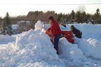
Photo from Cleveland, Ohio to the south by Andre Bernier, WJW-TV, Cleveland, Ohio. See larger image here.
Andre adds the following: After running a snowfall departure all winter at the NWS Cleveland, we are now well into surplus. Oddly enough, the rest of the cities around us carried surpluses all year. As of today (snowfall departures):CLE = +13.1”, CAK = +27.2”, MFD = +39.9”, TOL = +17.8”, YNG = +48.5” !!!!!! Youngstown has now surpassed the previous snowiest winters in recorded history and we still have March and April to go.
|
|
|
|


