

Alexandre Aguiar, MetSul Weather Center
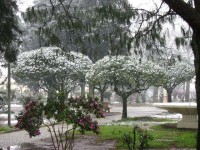
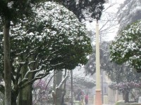
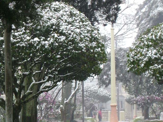
This day will go in our climatic history of the southernmost state of Rio Grande do Sul as one of the coldest ever witnessed in September. It was an amazing day. Temperatures below 5 degrees Celsius during afternoon hours are quite rare even in the coldest months of calendar from June to August, but today temperature dropped to 2 degrees in several cities after midday with the lows occurring during the afternoon. What began in the morning as granular snow and sleet quickly became moderate to heavy snow in the afternoon. The city of Pinheiro Machado (450 meters) never could expect to be whitened, despite the snow forecast from MetSul Weather Center, the only public or private weather institution in Brazil to warn on the snow.
See larger image here.
People could not believe the scenes of cars covered by ice and the fields whitened just after three days the region experienced a warm spell that brought highs over 30 degrees Celsius. MetSul surveyed 14 cities with observations of sleet, granular snow and snow. In the cities of Pinheiro Machado, Piratini and Canguçu the snow accumulated in the ground. Snow events in these areas are rare due to the lower altitudes compared to the mountains of 1.000 to 1.800 meters further north in Southern Brazil, but this time nature gifted the people of Southern Rio Grande do Sul. If snow is rare, to get accumulation is astonishing. It was the most impressive snow event in some areas since the 80s. Pinheiro Machado was the city to get more snow in this historic day.
Snow mixed with rain was also observed in Northern Uruguay. In the southern areas of Rio Grande do Sul, temperature dropped in the afternoon to 2,5ºC in Bagé, 2,7ºC in Santana do Livramento, 2,2ºC in Canguçu and 3,1ºC em Caçapava do Sul. MetSul’s chief meteorologist Eugenio Hackbart notes that it was for sure one of the coldest ever recorded afternoons in September in a century. Hackbart explained that the synoptic pattern that favored this Friday snowfall in Rio Grande do Sul (Brazil) was very similar to the one that produced the first snow in Buenos Aires since 1918 last year. The region was covered by a very cold air mass and a low pressure system advanced from North Argentina, bringing rain that converted to snow under the influence of the frigid polar air.
Meteorologist Eugenio Hackbart, a long time declared skeptic on manmade global warming, observed that extreme cold or snowfall events tend to occur during winter with negative PDO, solar minimums and La Nina. The most important snow events in Southern Brazil during the last 50 years, according to him, occurred at or around the 11-year cycle solar minimum. “Of course, it snow in year of heightened solar activity and El Nino, but history tells the most impressive episodes took place in winters either with La Nina or negative PDO in the Pacific or during periods of lowered solar activity”, he says. MetSul’s meteorologist also notes that the return of the colder winters and the major snow events to the area of the Southern Cone of South America may be the result of the ongoing cooling trends observed in the planet this decade. “This is no coincidence”, he says.
See larger image here. See full story and many more photos here.