

By Joseph D’Aleo, CCM, WeatherBell Analytics
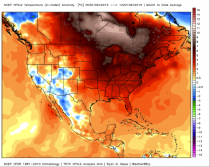
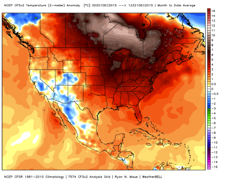
The year 2015, which started with the coldest January to March for the Northeast (10 states plus DC) and warm dry southwest, will end with an all-time warmest December for the United States (3rd warmest in the satellite era since 1979 globally). This is thanks in part due to a strong El Nino.
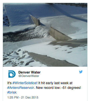
It was colder west and snowy in the mountains. See how Colorado Weather Station Hits -51F, Ties One Of Coldest Temperatures Ever Recorded.

On the morning of December 17 the thermometer at Antero Reservoir dropped to an astounding -51F. The last time that happened was on Feb. 8, 1989.
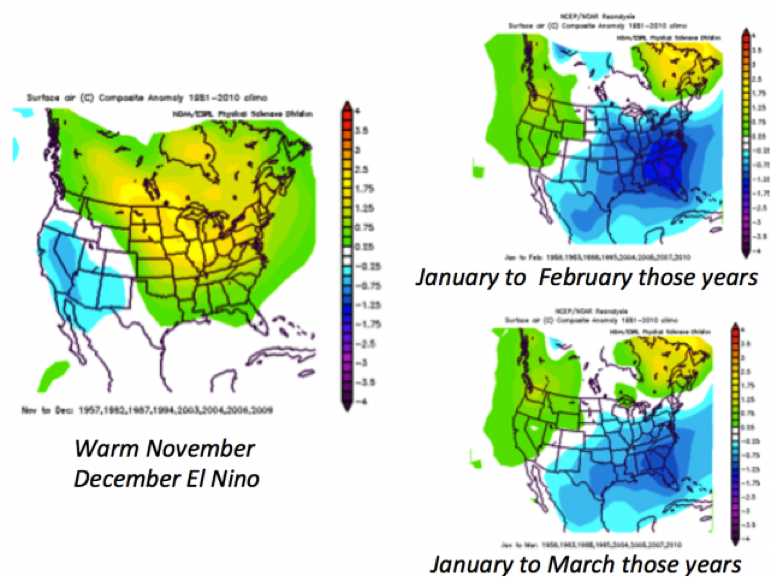
But like last year when December and Christmas were warm, the pattern will flip. The change will come a bit earlier than 2014/15. There are a lot of reasons to believe this. Warm November and December El Ninos often flip in January to March.
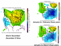
Enlarged
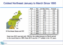
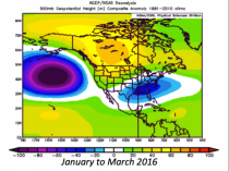
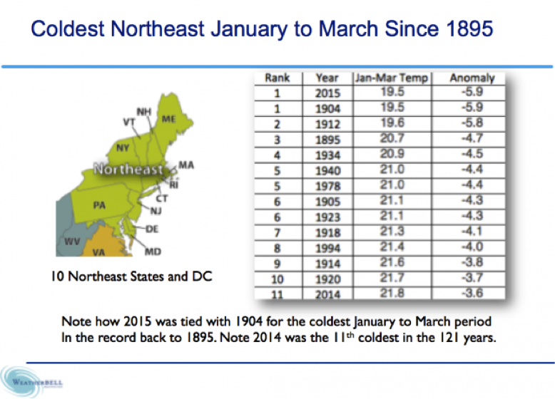
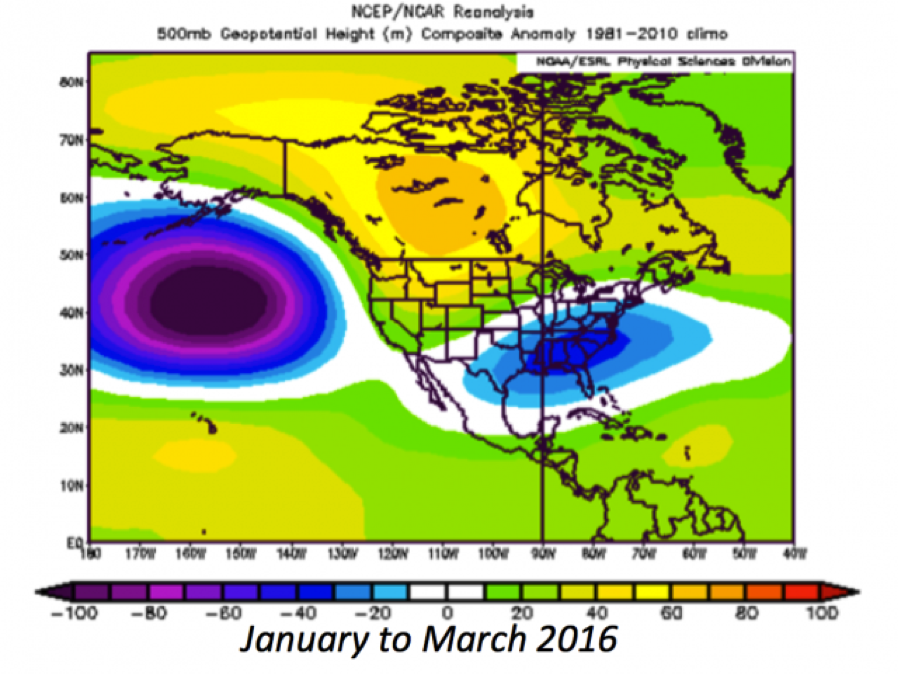
In the strong El Nino of 1965 the Upper Midwest including the Great Lakes and Minnesota and Iowa went from +7.9F in December to -7.2 in January. The second year El Nino of 1987/88 went from +6.5 to -1.8F in January and -3.7F in February. Last year it took a little longer in the weaker Modoki going from +6.1F in December to -8.4 by February. In the 10 northeast states plus DC we went from +5.9F in December to -2.6F in January, an amazing -10.4F in February and -4.5F in March. That made the region the coldest ever since 1895.
The media downplayed this away from the buried cities and NOAA in their winter highlights focused first on the warmth and dryness in California. In the prior winter, which featured record snow in the Great Lakes area and the coldest December to March in Chicago’s long history, it got a media attention during the coldest days mainly because of the term ‘polar vortex’, which sounded like something unique and that we somehow caused.
We hear references to 1997/98 as proof super NINOs bring blow torch winters and high confidence that this will be one. However there are more than subtle differences with 1997/98 as JB, TD and I have discussed.
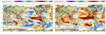
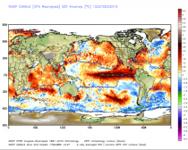
We see the difference from 1997 shown below is significant east of 150W (this year is much cooler) while it is warmer near the dateline than 1997.
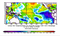
The cooler east and warmer central makes it more Modoki like which means the east is able to see the arctic air come south around the retrogressing western and central Canada ridge into the developing eastern (southeastern) CONUS trough.
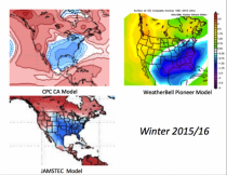
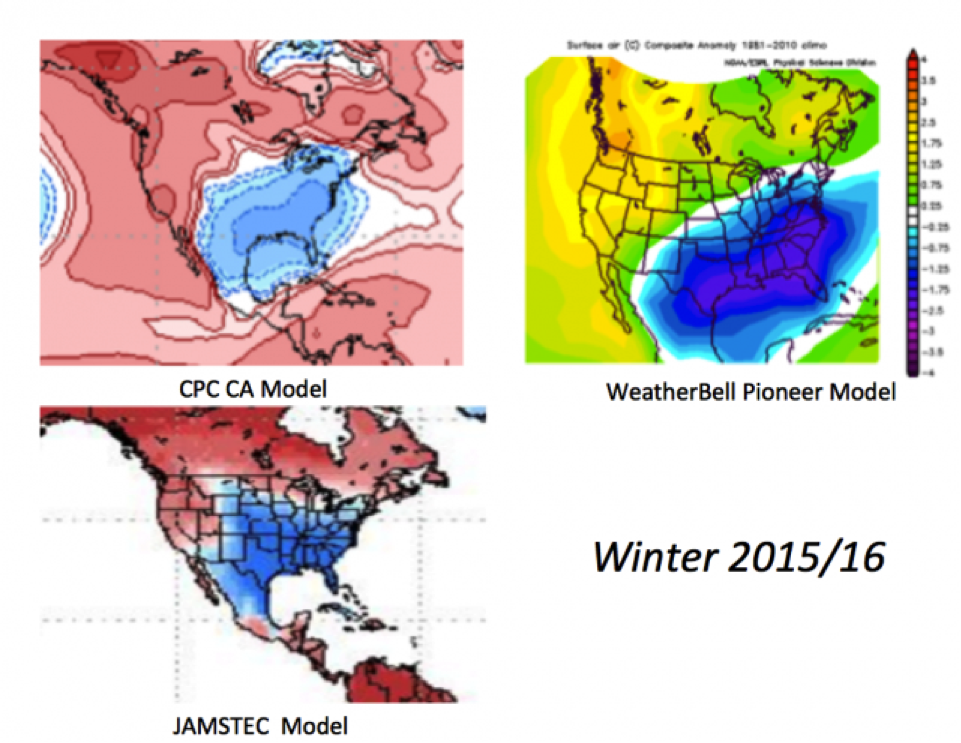
Next we have good agreement on the seasonal tools we trust. The CPC CFSv2 as it always does, will be last to ‘see the light’. But our 22 input Pioneer Model, the CPC CA and JAMSTEC agree with the change.
Enlarged
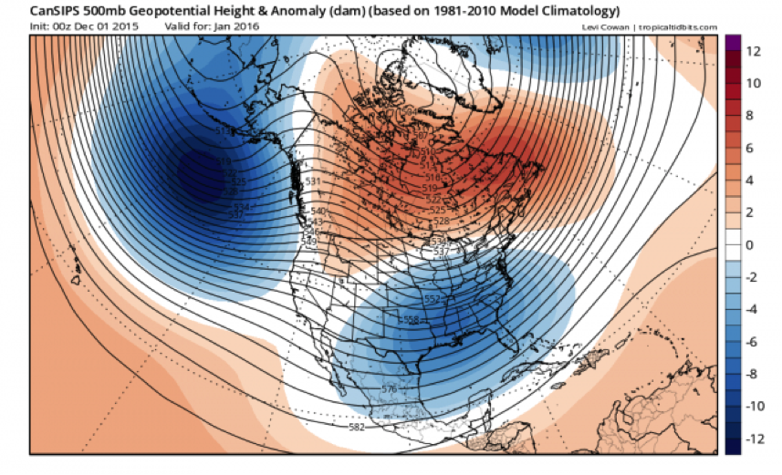
Though just January is shown, the CANSIPS (as shown on the Tropical tidbits site) model shows a similar pattern evolving.
Enlarged
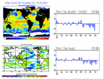
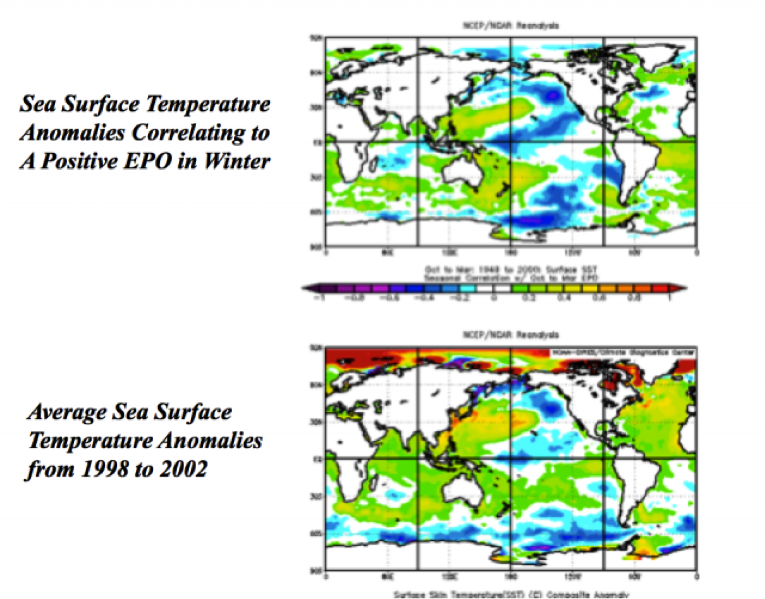
Then as I posted a few days ago, the EPO which has been positive (which favors warm central and eastern US), is not favored with the warm water off the west coast. Cold water like we had 1998-2002 and again 2011 to 2013 favors a +EPO. Warm water, which came on in 2002/03 and 2013/14 favors a -EPO.
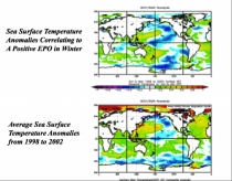
Enlarged
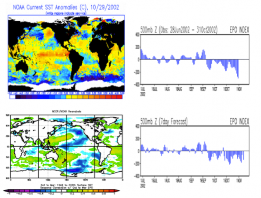
See how the developing warm northeast Pacific caused the dominant +EPO that had prevailed into 2002 to take a dive.
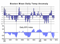
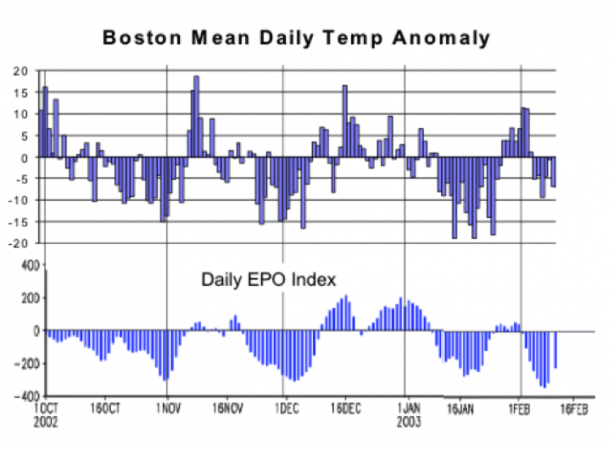
See how quickly the EPO changes cause the temperatures to readjust - here for BOS.
The warm water and El Nino becoming Modoki like should favor a -EPO increasingly by 2016.
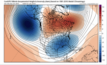
I had indicated the pattern would start to appear, somewhat inconsistently, in the models by the solstice. Indeed they have. The EPS long range shows it in late January. Come to Weatherbell and see the daily, weekly and even the 45 day European high resolution data.
The op run EC shows an impressive cold outbreak and developing east coast threats and widespread snows next month.
Even the warm CFS has a snowy period ahead.
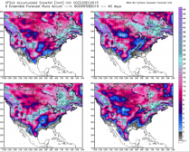
Enlarged
Note: Our team does daily briefings of which the above is an abbreviated version of. We do daily videos as well, explaining and further expounding on our forecasts and the reasoning them. We specialize in long range and correctly forecast up to 9 months in advance the last two winters and summers. If weather is of interest or affects your business please consider becoming party of the Weatherbell clients family, 4000 strong.