Apr 11, 2008
Geologist: Sun’s Shift Could Mean Global Chill
By John Stark, The Bellingham Herald
Fluctuations in solar radiation could mean colder weather in the decades ahead, despite all the talk about global warming, retired Western Washington University geologist Don Easterbrook said Tuesday. Easterbrook is convinced that the threat of global warming from mankind’s carbon dioxide pollution is overblown. In a campus lecture, he cited centuries of climate data in an effort to convince a somewhat skeptical audience that carbon dioxide’s impact on climate is being much exaggerated by former U.S. Vice President Al Gore and by scientists who appear to have won the debate over global warming.
“Despite all you hear about the debate being over, the debate is just starting,” Easterbrook said. Easterbrook doesn’t deny that the Earths climate has been warming slowly since about 1980. But he argued that this warming trend fits a longstanding pattern of warming and cooling cycles that last roughly 30 years. Sunspot activity and other solar changes appear to explain the 30-year cycles, he said. If that pattern persists, the earth could now be close to the next 30-year cooling cycle, Easterbrook said.
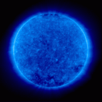
NASS extreme ultraviolet solar view - still quiet almost 12 years now since last solar minimum
He noted that the 2007-08 winter set records for cold and snow in many parts of the globe. According to the data he displayed, the Earths temperature hit a peak in 1998 and has been steady or slightly cooler since then. “One cold winter doesnt mean much of anything,” he said. “A 10-year trend is interesting.” Read more here.
Dr. Don J. Easterbrook, Professor Emeritus Geology, Western Washington University, author of 8 books, 150 journal publications with focus on geomorphology; glacial geology; Pleistocene geochronology; environmental and engineering geology
Apr 11, 2008
Is the Causal Link Between Cosmic Rays and Cloud Cover Really Dead??
By Nir Shaviv, Science Bits
Just recently, Sloan and Wolfendale published a paper in Environmental Research Letters, called “Testing the proposed causal link between cosmic rays and cloud cover”. In the Institute of Physics Press Release, it said, “New research has deal a blow to the skeptics who argue that climate change is all due to cosmic rays rather than man made greenhouse gases”. Did it really? First, we should note that so called “skeptics” like myself or my serious colleagues never claimed that cosmic rays explain all the climate change, it does however explain most of the solar-climate link and a large fraction (perhaps 2/3’s of the temperature increase over the 20th century).
Now for the paper itself. Sloan and Wolfendale raise three points in their analysis. Although I certainly respect the authors (Arnold Wolfendale is very well known for his contributions to the subjects of cosmic rays and high energy astrophysics, he was even the astronomer royal, and for good reasons), their present critique rests on several faulty assumptions. Here I explain why each of the three arguments raised cannot be used to discredit the cosmic-ray/climate link.
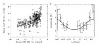
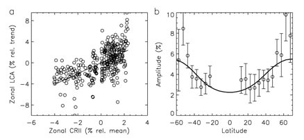
(From Usoskin et al. 2004). See large image here. The observed latitudinal variation in the cloud cover as a function of the magnetic latitude (right) or as a function of the atmospheric ionization variations (left). The graphs clearly demonstrate that the cloud cover varies as expected from the ionization variations.
Sloan and Wolfendale raised three critiques which supposedly discredit the CRF/climate link. A careful check, however, reveals that the arguments are inconsistent with the real expectations from the link. Two arguments are based on the expectation for effects which are much larger than should actually be present. In the third argument, they expect to see no phase lag, where one should actually be present. When carefully considering the link, Sloan and Wolfendale did not raise any argument which bares any implications to the validity or invalidity of the link.
One last point. Although many in the climate community try to do their best to disregard the evidence, there is a large solar-climate link, whether on the 11-year solar cycle (e.g., global temperature variations of 0.1C), or on longer time scales. Currently, the cosmic-ray climate link is the only known mechanism which can explain the large size of the link, not to mention that independent CRF variations were shown to have climatic effects as well. As James Whitcomb Riley supposedly once said: “If it walks like a duck and quacks like a duck, I would call it a duck”. Read the detailed Shaviv reply to the Sloan and Wlfendale points here.
Apr 11, 2008
Strong Spring Storm Brings Variety from Blizzard Conditions to Tornadoes
By Joseph D’Aleo, CCM
A week ago, we blogged that the end of this week a major storm appeared likely with the possiblility of numerous tornadoes for the south central and a spring blizzard to the northern plains.
That storm is rolling through the central states Thursday and Friday. Blizzard warnings are in effect for parts of the northern plains from South Dakota to Minnesota with up to 10 to 15 inches of windblown snow. In parts of Minnesota and especially south and east in Iowa and Wisconsin and Michigan, they have had enough of the snow for one year. You will enjoy this youtube video song from Minnesotans for Global Warming.
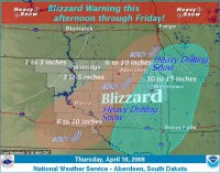
See larger image here
Meanwhile in the warm sector of the storm there is a moderate risk of severe westher over parts of the Mississippi Valley and a slight risk for surrounding areas. Not a superoutbreak but probably one with dozens of severe weather reports with tornadoes, strong wind and hail over the next two days. See the reports from Thursday here.
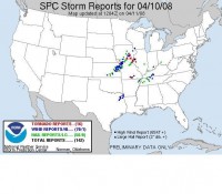
See larger image here
Many areas of the east and south ahead of the storm are enjoying warm spring weather. But by Sunday into early next week, unusual cold weather will settle in for a few days. That could serve to be a problem for the Georgia peach crop (worth $35 million) and other early crops in the southeast. You can track the severe weather here and winter storm and then freeze threat warnings and advisories here.
Apr 09, 2008
Climate Change Confirmed but Global Warming is Cancelled
Owen McShane, New Zealand National Business Review
In December last year, at the UN conference in Bali, I heard Viscount Monckton present a paper prepared by himself, the Australian Dr David Evans and our own Dr Vincent Gray (who were at Bali, too) that showed while the IPCC models predict that greenhouse gases would produce an extensive “hot spot” in the upper troposphere over the tropics, the satellite measurements show no such hotspots have appeared. Monckton and Evans found a large part of this discrepancy is the result of some basic errors in the IPCC’s assessment of the Stefan-Boltzmann equation. When they applied their revised factor to the effect of greenhouse gases, the temperature rise was about a third of that predicted by the IPCC. So by late last year we not only knew IPCC forecasts of atmospheric global warming were wrong; we were beginning to understand why they are wrong.
The climate sceptics have had to explain why the hotspots are not where they should be - not just challenge the theory with their observations. This is why I felt so lucky to be in the right place at the right time when I heard Roy Spencer speak at the New York conference on climate change in March.
Spencer was drawing on observations and measurements from the new Aqua satellites to explain the mechanism behind this anomaly between model forecasts and observation. You may have heard that the IPCC models cannot predict clouds and rain with any accuracy. Their models assume water vapour goes up to the troposphere and hangs around to cook us all in a greenhouse future.
However, there is a mechanism at work that “washes out” the water vapour and returns it to the oceans along with the extra CO2 and thus turns the added water vapour into a NEGATIVE feedback mechanism. The newly discovered mechanism is a combination of clouds and rain (Spencer’s mechanism adds to the mechanism earlier identified by Professor Richard Lindzen called the Iris effect). The IPCC models assumed water vapour formed clouds at high altitudes that lead to further warming. The Aqua satellite observations and Spencer’s analysis show water vapour actually forms clouds at low altitudes that lead to cooling.
This has struck the alarmists like a thunderbolt, especially as the lead author of the IPCC chapter on feedback has written to Spencer agreeing that he is right! There goes the alarmist neighbourhood! Read more here.
Apr 08, 2008
Snow World - What a Year for Snow in Unusual Places
By Joseph D’Aleo on Intellicast
For years, I wrote stories on weather and climate on Intellicast.com. I will be doing weekly stories on the weather there again starting today. The first summarizes the unusual snowy winters of 2007 in the Southern Hemisphere and 2007/08 in the Northern Hemisphere. It snowed in places where snow is rare or unheard of, and many all-time snow records were set in other places used to snow in winter.
Since the article was penned last week, St. Johnsbury, Vermont came in with a new seasonal snow record at the Fairbanks Museum and Planetarium with 139.1 inches, just eclipsing the mark of 139.0 inches set in 1968-69. According to Mark Breen the Museum’s meteorologist, records go back to 1894, and the observing site is essentially the same throughout the period of record. It has been an amazing winter there Mark noted. The snowiest winter season - December, January, and March - with 119 inches, the snowiest December of record - 54.1 inches, the only winter with two months exceeding 40 inches of snowfall, and one of the longest continuous snowcover seasons (they still have 15 inches of snow at the stake).
Also all the way acrosss the country to the northwest, Spokane, Washington found their seasonal total move into second place all-time with 89.4 inches, second only to 1949-50. Stowe, Vermont is pushing 400 inches and Vail, CO 420 inches with another storm brewing. In fact in all these places additional snow is very possible before they put away their snow sticks.
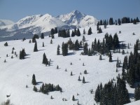
Photo of Vail this week courtesy of Tim Kelley. See larger image here.
In the middle, Minnesota saw a major snowstorm with up to 32 inches of snow that the Minnesota Climatology Working group wrote about here, with another snowstorm on the way.
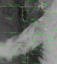
Visible satellite of the recent snowfall 1:15pm CDT on April 7, 2008. There are clouds obscuring the snow over the right side of the photo. Courtesy Grand Forks National Weather Service.
Across the Atlantic, the UK is getting an unusual April snow. Britain saw its worst April snowfall for nearly 20 years yesterday. Up to three inches of snow fell in parts of southern England and temperatures were below freezing in many places even at midday. The Arctic cold snap meant more misery for passengers at Heathrow’s Terminal 5, where British Airways cancelled more than 100 flights. Both Heathrow’s runways briefly closed for de-icing. Gatwick’s runway closed for two hours to clear snow, with 55 flights abandoned.
See the Intellicast story “Snow World - What a Year for Snow in Unusual Places” here.
|

