Earlier this month, The New York Times featured an article titled “Hockey in the Desert.” The article concluded that by building a hockey stadium in Las Vegas, the National Hockey League was contributing to climate change. The phrase “contributing to” is used over and over by political leaders and the media to voice concern about human-caused global warming, but “contributing to climate change” is a meaningless phrase.
In his address at Georgetown University in June of 2013, President Barack Obama stated, “...the planet is warming, and human activity is contributing to it.” In 2011, New Jersey Governor Chris Christie said, “...climate change is occurring and that humans play a contributing role...” In Congressional confirmation hearings, Energy Secretary Rick Perry affirmed that man-made activity was contributing to climate change.
Every human activity contributes to climate change. If you have a housecat, it “contributes to” climate change. As we burn sugars in our body, we produce carbon dioxide (CO2). Every time you exhale, you breathe out 100 times the concentration of CO2 in the atmosphere. The real question is “What is the size of human contribution compared to natural factors?”
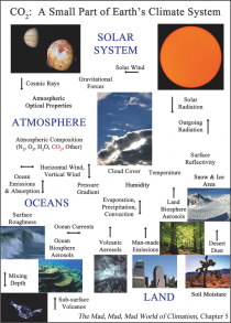
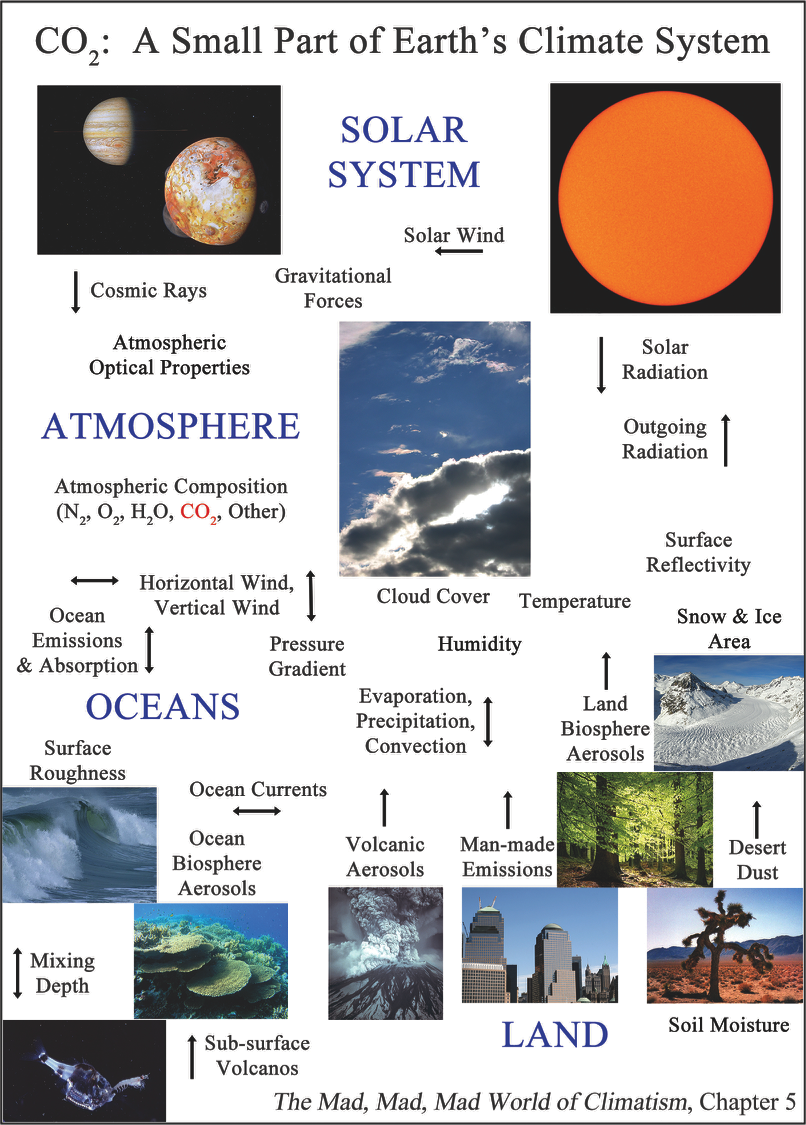
Earth’s climate is amazingly complex. It’s driven by gravitational forces of our solar system, radiation from the sun, and cosmic rays from stars in deep space. Climate is a chaotic, interdependent system of atmosphere, biosphere, ocean, and deep oceans. Climate has been changing through cycles of warming and cooling, tropical ages, temperate ages, and ice ages throughout all of Earth’s history. Climate change is not only real, it’s continuous.
Energy from the sun drives all weather on Earth. Sunlight falls directly on the Equator and Tropical Regions, where much energy is absorbed. Sunlight falls indirectly on Polar Regions. All elements of Earth’s weather, storm fronts, hurricanes, the jet stream, and even ocean currents, are driven to redistribute energy from the tropics to the poles.
The oceans have a powerful effect on Earth’s climate. The Gulf Stream current in the Atlantic Ocean dominates weather and temperatures in Europe. The El Nino cycle in the Pacific Ocean affects weather all over the world. The oceans have 250 times the mass of the atmosphere and can hold more than 1,000 times the heat.
Aerosols are an important factor in Earth’s climate. Dust from volcanos, desert dust, and pollen from plants rise into the atmosphere and influence the climate. Yet today’s climate scientists are obsessed with the level of atmospheric carbon dioxide, a small part of the overall picture.
Carbon dioxide is a trace gas. Only four of every 10,000 molecules in our atmosphere are CO2 and the amount that human industry could have added over all of our history is only a fraction of one of those four molecules.
Earth’s greenhouse effect, the capture of outgoing infrared radiation by greenhouse gases in the atmosphere, is said to be strengthened by emissions from industry and is blamed for human-caused global warming. But even the greenhouse effect is dominated by natural factors. Earth’s dominant greenhouse gas is neither carbon dioxide nor methane. Water vapor is Earth’s dominant greenhouse gas. Somewhere between 70 and 90 percent of the greenhouse effect is caused by water vapor and clouds.
Even the majority of the carbon dioxide in our atmosphere was placed there by nature. The oceans hold 50 times as much carbon dioxide as the atmosphere and the oceans are continuously releasing CO2 and absorbing CO2. When plants die, they release carbon dioxide, and they absorb CO2 when they grow. Volcanos above the surface of the ocean, and about ten times as many under the surface of the ocean, continuously emit CO2 and other gases into the environment.
Every day, nature puts about 20 times as much carbon dioxide into the atmosphere as all of human industry, and removes about the same amount. If we halted all industrial CO2 emissions, we probably could not measure a change in global temperatures.
Political leaders and newscasters, understand that the phrase “contributing to climate change: is meaningless, so please try to use something a little more intelligent.
Steve Goreham is a speaker on the environment, business, and public policy and author of the book Outside the Green Box: Rethinking Sustainable Development.
From the “heat on the computer brain” department (h/t to Joe D’Aleo)
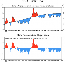
Portugal’s Met Office has retracted its prediction that temperatures in the country could reach 50C - the hottest ever recorded on mainland Europe - this week, drastically revising the forecast down by 10 degrees.
Facebook/ Comentadores
In a statement, the IPMA said forecasts published to its website and app on Tuesday had been “overestimated” for the region between Melides and Vila Nova de Milfontes, and in particular the city of Sines, where temperatures were predicted to reach 50C on Thursday and 46C on Friday.
The forecasts were the result of a “statistical method” applied to numeric models, it said.
The IPMA said the actual temperatures expected for these days were between 40C and 42C.
“This situation arises from the exceptional temperature episode above the normal values predicted for the beginning of August, after a long period of below-normal temperatures for the time of year,” the statement said.
ICECAP NOTE: See the cool summer to date in southern Portugal near Sines.
Full story here. Tony Heller compares the fake news heat record to the record heat of 1881 here.
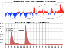
Observations during lunar eclipses show how Earth’s atmosphere has cleared, letting in more sunlight
Strange but true: You can learn a lot about Earth’s climate by watching a lunar eclipse. This week at the 46th Global Monitoring Annual Conference (GMAC) in Boulder, CO, climate scientist Richard Keen of the University of Colorado announced new results from decades of lunar eclipse monitoring.
“Based on the color and brightness of recent eclipses, we can say that Earth[s stratosphere is as clear as it has been in decades. There are very few volcanic aerosols up there,” he explains.
This is important, climatologically, because a clear stratosphere “lets the sunshine in” to warm the Earth below.
To illustrate the effect that volcanic aerosols have on eclipses, Keen prepared a side-by-side comparison (above) of a lunar eclipse observed in 1992 after the Philippine volcano Pinatubo spewed millions of tons of gas and ash into the atmosphere vs. the latest “all-clear” eclipse in January 2018.
“Compared to the murky decades of the El Chichon and Pinatubo, the clear stratosphere since 1995 has allowed the intensity of sunlight reaching the ground to increase by about 0.6 Watts per square meter,” says Keen. “That’s equivalent to a warming of 1 or 2 tenths of a degree C (0.1 C to 0.2 C).”
“In other words,” he adds, “over the past 40 years, the decrease of volcanic aerosols and the increase of greenhouse gases have contributed equally to the total warming (~0.3 C) observed in global satellite temperature records.”
Total lunar eclipses happen somewhere on Earth typically once or twice a year. Keen is looking forward to the next one on July 27, 2018, which will be the longest lunar eclipse of the century. The Moon will pass almost directly through the middle of Earth’s shadow, remaining inside for 1 hour and 43 minutes. That’s just a few minutes shy of the theoretical maximum.
“This will give us plenty of time to measure the color and brightness of Earth’s shadow and, thus, the aerosol content of the stratosphere,” says Keen.
For more information about lunar eclipses and climate change, check out Keen’s poster from the GMAC.
Note as we showed here, the satellite temperatures show clearly the effects of high and low aerosols using NASA’s Aerosol Optical Thickness (Sato).
And this annual temperature plots for high and low aerosols show the patterns globally.
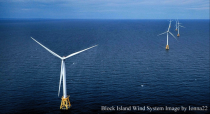
Several eastern US states are planning major investments in offshore wind. Wind turbines are touted as clean, green, and economically sound. But experience from around the world shows that offshore wind systems are both expensive and at high risk for early system degradation.
The governors of Massachusetts, Rhode Island, New York, New Jersey, Maryland, and Virginia have signed executive orders or passed laws to procure offshore wind systems valued at billions of dollars. Officials are eager to win leadership in what is perceived to be a new growth industry. The US Department of Energy has funded over $200 million in offshore wind research since 2011.
Massachusetts Governor Charlie Baker signed a law in 2016 requiring utilities to purchase 1,600 megawatts of electricity from offshore wind systems over the next 10 years. The law requires that wind systems be “cost effective to electric ratepayers.” But history shows that costs are likely to be far above the New England wholesale market price of 5 cents per kilowatt-hour.
Massachusetts paid solar generators a subsidy of 25 cents per kilowatt-hour during the state’s solar build-out in 2013. Rhode Island’s Block Island wind system, the first offshore system in the United States, now receives over 27 cents per kW-hr, with an annual guaranteed rate increase of an additional 3.5 cents per kW-hr. New England residents must enjoy paying renewable generators more than six times the market price for electricity.
In May of last year, Maryland’s Public Service Commission (PSC) approved electricity-rate increases to fund two wind projects east of the Ocean City shoreline. Maryland’s residents will pay an additional $2 billion over 20 years in increased electricity rates to support the projects. The Maryland PSC claims the systems will create jobs and spur economic growth, but analysis shows that rate payers will pay $200,000 for each of the estimated 9,700 jobs created.
Also in 2017, New York Governor Andrew Cuomo announced approval of the South Fork Wind Farm off the coast of Long Island, stating “This project will not only provide a new reliable source of clean energy, but will also create high-paying jobs, continue our efforts to combat climate change and help preserve our environment for current and future generations of New Yorkers.”
But are offshore wind systems reliable? Ocean-located turbines face one of the harshest environments on Earth. Turbines are battered by wind and waves, struck by lightning, and need to endure salt spray that is very corrosive to man-made structures.
In February, it was reported that Danish wind operator Orsted must repair more than 600 wind turbines due to early blade failure. The blades are to be disassembled and brought to shore for repair after only five years of operation, at a cost on the order of $100 million.
Then in March, it was announced that wind turbines at the 175-turbine London Array, the world’s largest offshore wind system, would also need major repairs after only five years of use. Few offshore systems have made it to the end their specified 25-year lifetimes without a major overhaul.
Wind turbines sited off the eastern US coast must survive brutal weather compared to offshore turbines in Europe. From March 1 to March 22 of this year, four powerful extratropical cyclones, called nor’easters, battered our east coast from Virginia to Maine. These storms produced ocean storm surges, large snowfalls, wind gusts of up to 100 miles per hour, and even 20 tornados.
Specifications call for wind systems to withstand gusts up to 156 miles per hour, but this isn’t good enough for some of our Atlantic hurricanes. Last September, hurricane Maria struck Puerto Rico with Category 4-strength winds and destroyed many of the wind turbines on the island.
Strong hurricanes occasionally collide with our eastern coastal states. The Great New England Hurricane of 1938 brought Category 3 winds to New York, Connecticut, and Rhode Island. The Great Atlantic Hurricane of 1944 delivered Category 2 winds along the coast from North Carolina to Maine. Hurricane Carol in 1954 and Hurricane Gloria in 1985 brought Category 3 winds to the shores of the wind system-promoting states.
Finally, the Norfolk and Long Island Hurricane of 1821 passed through most of the proposed wind turbine sites with up to Category 4 wind strength. The expensive wind systems planned by Atlantic States could all be destroyed by a single well-placed hurricane.
Offshore wind turbines are expensive, prone to early degradation, and in the case of the US East Coast, at risk in the path of strong hurricanes. State officials should reconsider their plans for offshore wind systems.
Steve Goreham is a speaker on the environment, business, and public policy and author of the book Outside the Green Box: Rethinking Sustainable Development.
A new study suggests those skeptical about climate change and climate alarmism behave in more climate-friendly ways than do those who are very concerned about the issue.
University of Michigan psychology graduate student Michael Hall’s study looked at 600 Americans who “regularly reported their climate change beliefs, pro-environmental behavior, and other climate-change related measures.”
The results, published in the Journal of Environmental Psychology, divided subjects into three categories: the “Skeptical,” the “Cautiously Worried,” and the “Highly Concerned.” As you might expect, the “Skeptical” were most opposed to government climate policies; however, they were also “most likely to report engaging in individual-level pro-environmental behaviors” (emphasis added).
On the other hand, the “Highly Concerned,” while very supportive of government action on climate, were the least likely to behave in eco-friendly ways.
Does this surprise anyone?
Pacific Standard has more:
On seven occasions- roughly once every eight weeks -participants revealed their climate change beliefs, and their level of support for policies such as gasoline taxes and fuel economy standards.
They also noted how frequently they engaged in four environmentally friendly behaviors: recycling, using public transportation, buying “green” products, and using reusable shopping bags.
While policy preferences of group members tracked with their beliefs, their behaviors largely did not: Skeptics reported using public transportation, buying eco-friendly products, and using reusable bags more often than those in the other two categories.
This pattern was found consistently through the year, leading the researchers to conclude that “belief in climate change does not appear to be a necessary or sufficient condition for pro-environmental behavior.”
Hall and his colleagues can only speculate about the reasons for their results. But regarding the concerned but inactive, the psychological phenomenon known as moral licensing is a likely culprit.
That “moral licensing” certainly sounds like an inconvenient truth regarding the best known climate alarmist, former veep Al Gore. His mansion reportedly uses 21.3 times more kilowatt hours than the average US household - “including 66,159 kWh just to heat his swimming pool [for a year] - but his camp counters with the following:
“[Gore] leads a carbon neutral life by purchasing green energy, reducing carbon impacts and offsetting any emissions that cannot be avoided, all within the constraints of an economy that still relies too heavily on dirty fossil fuels,” said Betsy McManus, Gore’s director of communications.
She just didn’t respond, however, when asked what those offsets are.


_thumb.jpg)


