

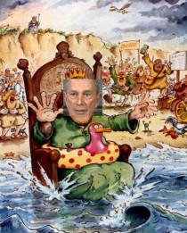
n a far-reaching plan that would reshape the coastline of the nation’s largest city, New York City Mayor Michael R. Bloomberg, the modern day King Canute, unveiled a $20-billion proposal Tuesday that he said will protect New Yorkers from disasters brought on by climate change including rising tides. Little Napoleon is delusional.
Fox News and the other media carried an AP story about the Bloomberg folly with forecasts that have a 0 (zero) percent chance of verifying.
“The projections paint an unsettling picture of New York’s future: a city where by the 2050s, 800,000 people could be living in a flood zone that would cover a quarter of the land, and there could be as many 90-degree days as is now normal for Birmingham, Ala.
Facing those new projections of the effects of global warming on the nation’s biggest city, Mayor Michael Bloomberg was scheduled to talk Tuesday about what to do about risks that Superstorm Sandy brought into stark relief.
“We have to look ahead and anticipate any and all future threats, not only from hurricanes and other coastal storms but also from droughts, heavy downpours and heat waves—many of which are likely to be longer and more intense in the years to come,” an excerpt from the mayor’s planned speech says.
Two top Bloomberg aides who oversaw the study underlying the speech, Seth Pinsky and Deputy Mayor Caswell Holloway, wouldn’t hint Monday at what the suggestions would be, what they might cost or how they might be financed. Many key decisions likely will come after Bloomberg’s third and final term ends this year.
Bloomberg said last winter the study would examine the pros and cons of building berms, dunes, levees and other coast-protection structures. But he has historically been cool to the idea of massive sea walls—and emphatic about not suggesting that people retreat from coastal communities.
The recommendations will draw from updated predictions from the New York City Panel on Climate Change, a scientists’ (???) group convened by the city.
The average day could be 4 degrees to nearly 7 degrees hotter by mid-century, the panel estimates in data Pinsky and Holloway discussed Monday. A once in a century storm would likely spur a surge 5 or more feet higher than did Sandy, which sent a record 14 foot storm tide gushing into lower Manhattan.
And with local waters a foot to 2 1/2 feet higher than they are today, 8 percent of the city’s coastline could see flooding just from high tides, the group estimates. Most of that coast is in a relatively undeveloped area near a bay.
City Hall, the state government and others have released warnings over the years about climate risks. The city has required some new developments in flood zones to be elevated and has restored wetlands as natural barriers, among other steps.
“Sandy, obviously, increased the urgency of dealing with this and the need to plan and start to take concrete steps,” Holloway said.
The new projections echo 2009 estimates from the climate change panel, but the timeframe for some upper-end possibilities has moved up from the 2080s to mid-century.
“The overall numbers are similar, but we have more compelling evidence now that (a more severe scenario from 2009) is looking like a more realistic possibility now,” due to improved computer models and more evidence that some ice sheets are melting, said Radley Horton, a climate scientist with Columbia University’s Earth Institute and a researcher with the city climate panel.
Scientists have reached a consensus on global warming but still debate how severe the effects will be.”
----------------------
How about zero?
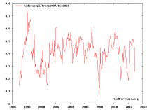
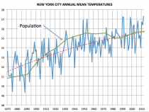
New York temperatures reflect the change in population since 1870 (from less than 1 million to 8.2 million in the five boroughs) but have shown little change for 16 years like the rest of the world. The greatest warming took place during the time the population grew fastest from the 1880s to 1930s. Temperatures and population in recent years have been just like the 1950s.
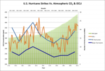
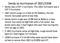
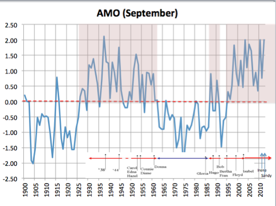
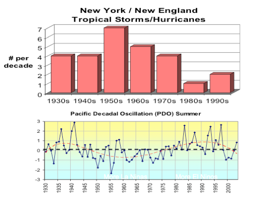
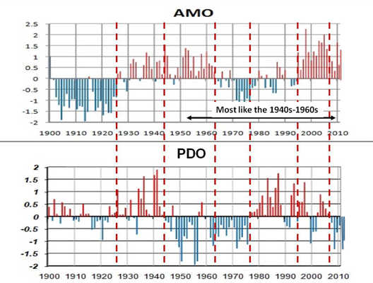
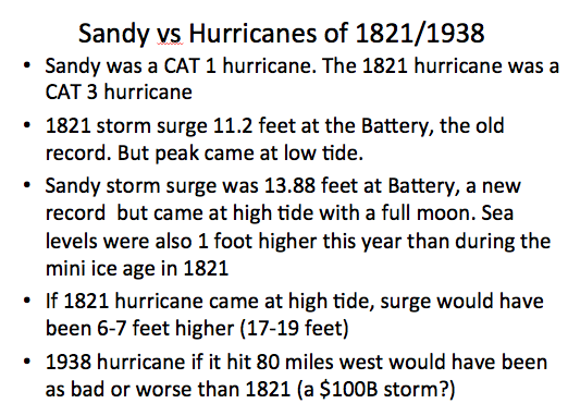
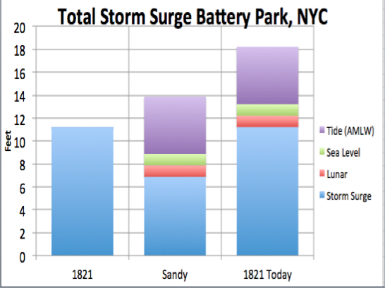
And Sandy was only a CAT 1 storm. There were 8 storms that made landfall in the northeast from 1938 to 1960, many CAT3. Landfalls of hurricanes along the east coast are favored when the Atlantic is warm (+AMO) and the Pacific cold (-PDO), which is the current state.
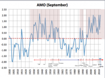
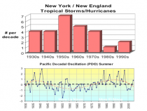

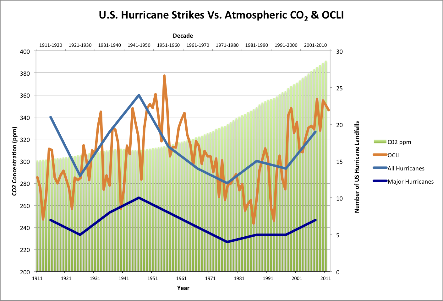
If we create an index of the two ocean oscillations (+AMO,-PDO) and call it the Ocean Cycle Landfall Index (OCLI), we see good agreement.
A similar state existed in the early and late 1800s. Landfalling storms on New York CIty occurred in 1815, 1821 and 1893. the 1821 was the worst storm.

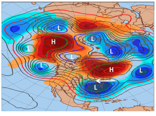
Could we see a storm worse than Sandy before the Atlantic cools in 5 to 10 years? YES! And with enhanced blocking in an era of low solar activity, a hit further west on the coast closer to NYC is enhanced just as we saw with Sandy.

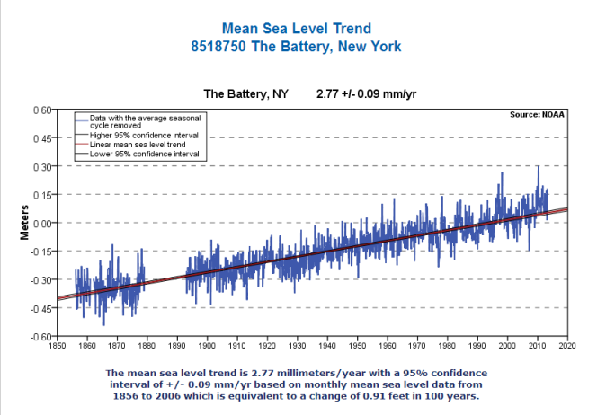
Will the Sea level go up a foot by 2020? Doubtful. Recall Hansen in 1988 predicted sea levels would inundate the West Side Highway and be lapping at the Goddard Institute (an important component of the mayor’s scientific advisory panel) Building in 20 years (2008). Sea level has risen 1 inch since 1988. Oh, well.
The Battery , NY Station ID: 8518750
Station Information
Latitude: 40° 42.0′ N Mean Range: 4.53 ft.
Longitude: 74° 0.8′ W Diurnal Range: 5.06 ft.
Established: May 24 1920
NOAA Chart #: 12335
Time Meridian: 75 W
Mean Sea Level Difference:
for 8518750 The Battery, NY
1983-2001 1960-1978 Difference:
5.86 ft.-5.65 ft. = 0.21 ft.

Based on current NOAA data, it will take over 100 years to gain a foot of sea level rise.
See what our friend and associate Anthony Watts found about the sea level story.
And, it really is easy to get freaked out if you don’t pay attention to anything but hype.