

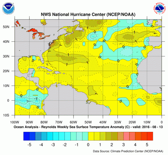
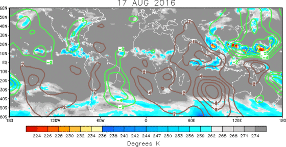
The models are smelling trouble for the western Atlantic. It should not surprise you given the SSTAs, the less hostile MJO and the calendar.
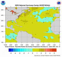
Water is warm throughout the Atlantic Basin, warmest in the west.
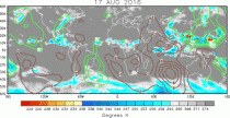
The MJO is becoming less hostile to convection. The green areas support outflow aloft, allowing thunderstorm clusters to more easily organize.
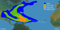
In August (usually after mid-month), the activity picks up in the entire development region.
Each of the global models develop storms. The scariest yesterday was the tropical storm friendly GEM. Overnight it was the GFS 06z.
ANALOG SUPPORT FOR TROUBLE
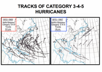
The CPC Constructed analog which looks back at SSTA patterns 45N to 45S several seasons has not surprisingly 1998 ranked high still but has 1960 just behind. The WB Pioneer model which looks at SSTAs there and in higher latitudes but also at atmospheric and oceanic and solar factors has a mix of troublesome tropical years in the top 10 including 1969, 2003, 2004, 2005, 1960 is not in the top 10 but not far behind.
1960 was famous for Hurricane Donna, a major hurricane which produced hurricane force winds in all the states on the east coast from Florida north. The year in the top 10 for both was 2003. 2003 had Isabel which pounded the Chesapeake Bay and Mid Atlantic.
Here is an NHC cliff noted recap of the highlights of Donna in 1960 and Isabel (2003).
Hurricane Donna 1960
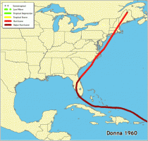
One of the all-time great hurricanes, Donna was first detected as a tropical wave moving off the African coast on August 29. It became a tropical storm over the tropical Atlantic the next day and a hurricane on September 1. Donna followed a general west-northwestward track for the following five days, passing over the northern Leeward Islands on the 4th and 5th as a Category 4 hurricane and then to the north of Puerto Rico later on the 5th. Donna turned westward on September 7 and passed through the southeastern Bahamas. A northwestward turn on the 9th brought the hurricane to the middle Florida Keys the next day at Category 4 intensity. Donna then curved northeastward, crossing the Florida Peninsula on September 11, followed by eastern North Carolina (Category 3) on the 12th, and the New England states (Category 3 on Long Island and Categories 1 to 2 elsewhere) on the 12th and 13th. The storm became extratropical over eastern Canada on the 13th.
Donna is the only hurricane of record to produce hurricane-force winds in Florida, the Mid-Atlantic states, and New England. Sombrero Key, Florida reported 128 mph sustained winds with gusts to 150 mph. In the Mid-Atlantic states, Elizabeth City, North Carolina reported 83 mph sustained winds, while Manteo, North Carolina reported a 120 mph gust. In New England, Block Island, Rhode Island reported 95 mph sustained winds with gusts to 130 mph.
Donna caused storm surges of up to 13 ft in the Florida Keys and 11 ft surges along the southwest coast of Florida. Four to eight ft surges were reported along portions of the North Carolina coast, with 5 to 10 ft surges along portions of the New England coast. Heavy rainfalls of 10 to 15 inches occurred in Puerto Rico, 6 to 12 inches in Florida, and 4 to 8 inches elsewhere along the path of the hurricane.
The landfall pressure of 27.46 inches makes Donna the fifth strongest hurricane of record to hit the United States. It was responsible for 50 deaths in the United States. One hundred and fourteen deaths were reported from the Leeward Islands to the Bahamas, including 107 in Puerto Rico caused by flooding from the heavy rains. The hurricane caused $387 million in damage in the United States and $13 million elsewhere along its path.
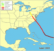
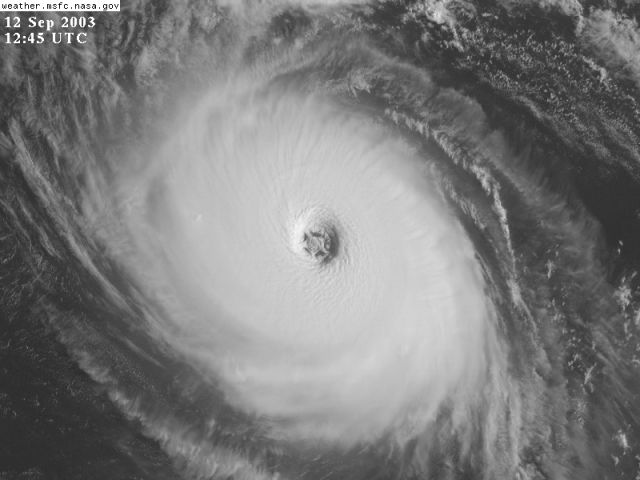
Hurricane Isabel 2003
<
a href="http://icecap.us/images/uploads/H10.gif" title="Enlarged">Enlarged
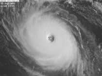
A well-organized but slow moving tropical wave that exited the African coastline on September 1st developed into Tropical Storm Isabel on the morning of September 6th. Isabel became a hurricane on September 7th and rapidly intensified to Category 4 hurricane strength on the evening of the 8th while the eye was located more than 1100 miles to the east of the Leeward Islands. This impressive hurricane reached Category 5 strength on September 11th, making Isabel the strongest hurricane in the Atlantic basin since Mitch in October 1998. The cyclone turned northwestward around the western periphery of the Atlantic ridge beginning on the 15th. Isabel began to weaken on the 15th as conditions aloft became more hostile, and it fell below major hurricane strength for the first time in eight days on the 16th.
Although weakening, Isabel’s wind field continued to expand as hurricane warnings were issued for most of the North Carolina and Virginia coastline, including the Chesapeake Bay. Isabels large eye pushed ashore just after the noon hour on September 18th near Drum Inlet along North Carolina’s Outer Banks. Isabel was the worst hurricane to affect the Chesapeake Bay region since 1933. Storm surge values of more than 8 feet flooded rivers that flowed into the Bay across Virginia, Maryland, Delaware, and Washington, D.C. Isabel brought tropical storm force gusts as far north as New York State as it moved inland. The most intense hurricane of the 2003 season directly resulted in 17 deaths and more than 3 billion dollars* in damages. The large wind field toppled trees and cut power to more than four million customers.