

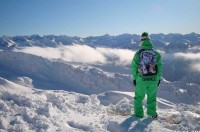
UK Snowboard Club
Gore is heading to Europe for the UN climate debacle. On cue mother nature strikes again.
20 year record snowfall in Dolomites enough to last all season. Some Swiss train services cancelled due to excess snow. Still more heavy snow in the Pyrenees. More snow for Scotland. www.Skiinfo.com is following still more heavy snowfalls across Europe over the past 48 hours, with much more snow in other parts of Europe and many areas of North America too. The snowfall has been so great that it has closed roads, brought down power lines and even led to the cancellation of some Swiss rail services this week.One of the greatest beneficiaries are the Italian Dolomites where 150cm (five feet) has fallen at Cortina in a 48 hour period up to Monday, with snow still falling. Alessandro Fregni of Skiinfo.com’s Italian office commented, “In three days ski areas have seen almost as much snowfall as for the whole winter last year.”
The snow has arrived with perfect timing for the ski resorts who are seeing a boom in ticket sales at a time of economic uncertainty. Alessandro believes the snow is enough to last all season and will also mean resorts can save money by not needing to use snow making equipment. However the snow is causing practical problems for both locals and those wanting to reach the snow with almost every pass in to the Dolomites closed on Monday and many villages without electricity. However the situation will be resolved quickly once the snow stops falling.
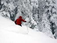
It was a similar if slightly less dramatic picture to the north where competitors at the annual season opening Santa Claus World Championships in Samnaun had difficulty getting to and from the event as Swiss public transport in the area struggled to cope with heavy snowfall there. On Monday rail services were cancelled in the area of Eastern Switzerland due to the snow. “We should have used their magic sleighs.” joked a bemused competitor after missing his flight home as a result.Most other Swiss resorts have great cover and more new snow. Skiinfo issued powder alarms in the past week for Skiinfo with 70cm (28 inches) and Davos 53cm (17 inches) of fresh snow each. Many major resorts now have snow depths of 2-3 metres (7 - 10 feet). In Austria the snow cover is also superb with Heiligenblut the biggest recipient of the weeks latest dump, receiving a metre (40 inches) of powder in the past seven days. Many of the open French ski areas have reported at least a foot of new snow in the past week. Several have much more including Les Arcs, with 80cm (32 inches). New openings this weekend include Les Orres, Chamrousse, L e Grand Bornand, Isola 2000 and Montgenevre. Alpe D’Huez and Courchevel will be fully open and Megève partly open.
It looks like the ski areas in the Pyrenees and elsewhere in Spain which dominated snowfall news in November with record pre-season accumulations leading top early openings of ski areas in the region will continue in to December, as the snow keeps falling.
Baqueria Beret in the Pyranees.
A new cold front has brought still more fresh powder to Spain (Formigal and Sierra Nevada have both received 70 cm/28 inches more powder in the past week) all the ski resorts in Spain will open for a three day holiday weekend. For Spanish skiers and boarders the Purísima Feast on December 8 is a must every year and represents the official opening of the winter season.On the French side of the range Cauterets opened last weekend with 80% of runs available on opening day and up to 150cm (five feet) of snow. Elsewhere in Europe conditions continue to be very good in Scandinavian countries too. Norway’s Hemsedal currently has 65cm (over two feet) of snow on its slopes, with Bjorli registering the greatest snow depth at present with 100 cm (40 inches). The country’s ski areas have received up to 38cm (15 inches) of new snow in the last week with Skiimnfo.com issuing a powder alarm for Trysil, the largest resort in Norway. The snowfall makes it possible for Trysil to open more slopes and lifts for the upcoming weekend, said Jan Linstad, Trysil ski area]s manager. In Eastern Europe it’s a more mixed picture with some warm temperatures limiting cover. However Slovenian areas are open and Bansko has opened in Bulgaria with largely machine made snow.
In Scotland The Lecht re-opened last week before closing for a second time in November as the snow thawed. However more snow fell yesterday (Tuesday, December 2), temperatures remain well below freezing and heavy snow is forecast for tomorrow, Thursday (December 4), raising hopes of a weekend re-opening. In North America the picture has improved dramatically in Colorado, just as it did this time last year before a meteoric snowfall season in which several resorts set record snowfall figures after a warm November 2007. One of the best reports is from Vail which has had 63cm (25 inches) of snow in the past week. Nearby Copper Mountain has also been able to open its Superpipe, the first on the continent this season. Conditions are generally less good on the countrys West coast however with delayed openings or limited cover at many ski areas. Further north it’s a mixed picture in Western Canada with Mount Washington announcing it will delay its opening due, planned for this Friday, December 5, due to lack of snow. “We have patchy snow on the ground right now after some rainfall last weekend,” explains resort spokesperson Brent Curtain. “We need to see approximately one metre of snow on the ground before we can begin slope preparations for our opening day. “Further north still however Alyeska in Alaska has opened with a huge five metre (200 inch) base, although temperatures were reported to be as low as a seriously chilly 8F at the ski area summit on Monday. On the other side of the region one of the early openers, Marmot Basin in Alberta, which has already seen 89cm (three feet) of snow this winter, opening another five runs. On North America’s East Coast most resorts are open and in the case of resorts in states like Maine and Vermont reporting “The best start to the season for years” with a foot (30cm) or more of natural snowfall at most, topped up by the extensive snowmaking systems common in the area. Further afield Japan has had its first taste of winter too. Grand Hirafu in Niseko opened on 22nd November with things not looking promising and very little snow in the village and just a light cover of snow on the top of the resort. True to its self-proclaimed status of “powder capital of the world” however, over a metre (40 inches) of snow then fell in just three days. Visit www.skiinfo.com to sign up for powder alarms from your favourite resorts, check current snow conditions and projected snowfalls with snow finder as well as exchange news and views in the Skier’ Lounge.
By Danny Fortson< Sunday Times
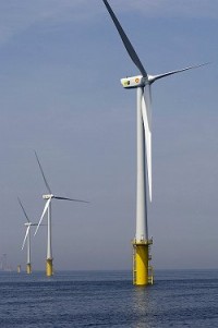
ROYAL DUTCH SHELL has become the second big energy company to abandon the UK wind-energy sector in the last month.
Shell, Danish firm Dong Energy and Scottish Power have cancelled the 800m UKpound Cirrus Array project off the northwest coast after five years and millions of pounds in investment. The consortium blamed Ministry of Defence concerns over radar interference from turbines.
Less than a month ago, Shell denied a Sunday Times report that it had exited the project. However, on Friday the company confirmed that it had no plans for further investment in the UK wind sector. Shell said: “The focus for new projects will be in North America where we can benefit from the availability of undeveloped wind resources to deliver wind energy at what we expect to be a competitive cost.” Last month BP also moved its wind-energy focus to America, citing generous subsidies and a less-onerous planning process.
Read more here.
And in the Sunday Telegraph, they report Wind Power Targets Unrealistic. A report by the Committee on Climate Change (CCC), published last week, maintained that wind farms could play a major role in helping Britain cut its harmful carbon emissions by 34 per cent in 2020 and 80 per cent by 2050.
It stated: “Despite the inherent intermittency of wind power supply, wind generation could make a significant contribution to total global electricity generation and be a major source of electricity in the UK (eg 30 per cent by 2020 and more beyond).” The CCC, chaired by Lord Turner, the former director general of the Confederation of British Industry, said that new techniques of energy storage would overcome the problem of maintaining a regular supply when the wind is not blowing.
But sceptics say this is far too ambitious because experts have not yet been able to devise effective ways of capturing and storing electricity generated by wind. That means a backup system, in the form of nuclear or coal- or gas-fired power stations, would always be needed. John Constable, director of policy and research at the Renewable Energy Foundation, a think tank, said: “To generate 30 or 40 per cent of our electrical energy from wind power would present unmanageable and unaffordable difficulties at the present.
“The CCC’s assertion to the contrary is simply out of step with the state of theoretical and empirical knowledge in the field. Betting on very heavy commitment to wind for carbon reduction is irrational and will result in the inevitable failure of our climate change policy. Wind has a role, but this role will be modest in scale.” Read more here.
By Roger Pielke Sr., Climate Science
The use of Arctic sea ice coverage as a climate metric has received wide science and media coverage. This issue is motivated by the recent large reduction in late summer areal coverage (e.g. see the data on the excellent website The Cryosphere Today).
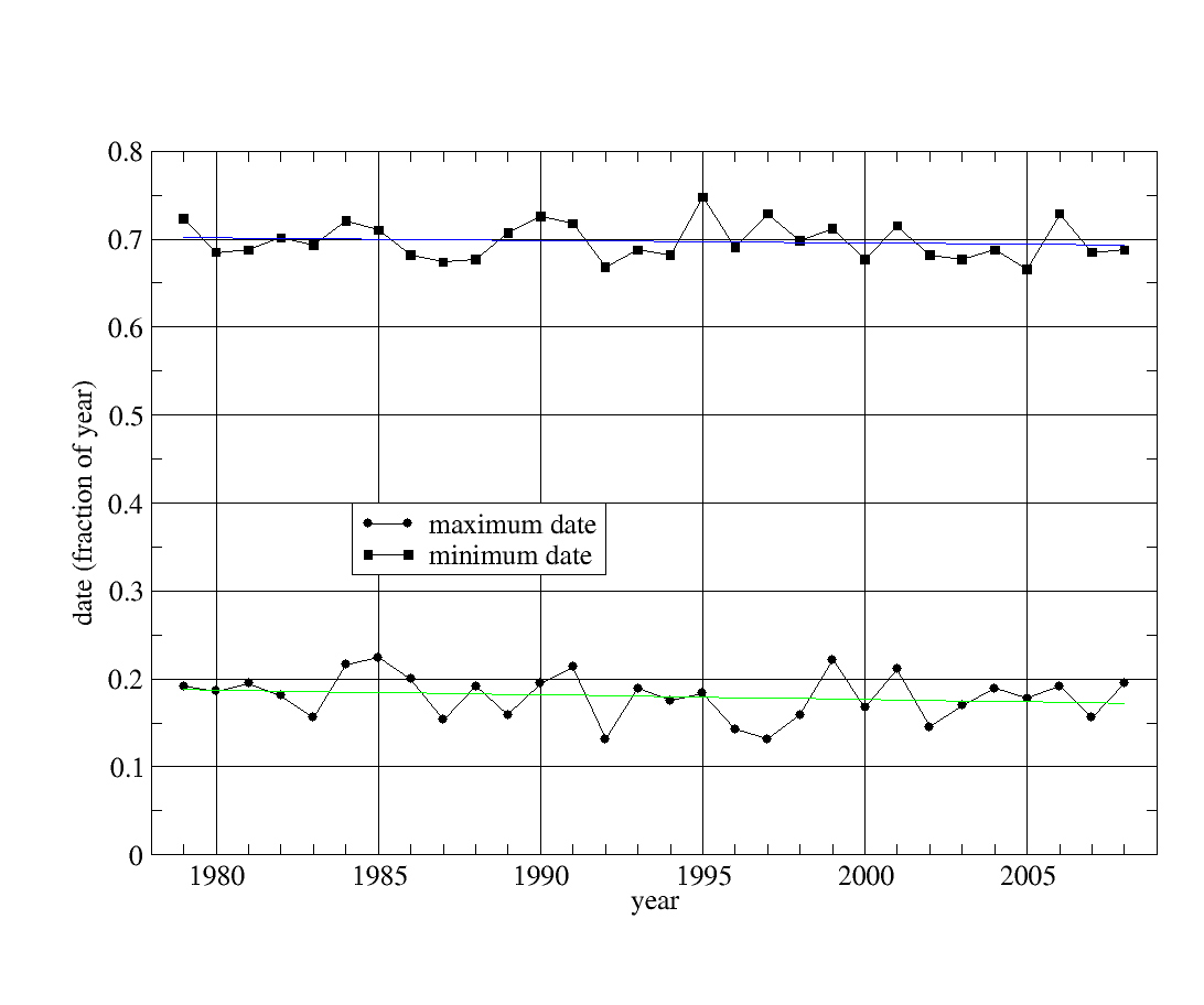
There is another sea ice metric to look at, however, and that is the date of the year of the minimum and maximum sea ice coverage. With the addition of well-mixed greenhouse gases into the atmosphere, we should expect the start of the freeze-up in the late summer/early fall to be later and the start of the melt in the late winter/early spring to be earlier.
Indeed, this is what is claimed in a recent talk by Mark C Serreze of the Cooperative Institute for Research in Environmental Sciences/National Snow and Ice Data Center (CIRES/NSIDC) at the University of Colorado Boulder (November 10 2008 - titled “The Emergence of Arctic Amplification"), where his abstract reads:"The concept of Arctic amplification is that rises in surface air temperature in response to increasing atmospheric greenhouse gas concentrations will be larger in the Arctic compared to the Northern Hemisphere as a whole. Model-projected Arctic amplification is focused over the Arctic Ocean. As the climate warms, the summer melt season lengthens and intensifies, leading to less sea ice at summer’s end. Summertime absorption of solar energy in expanding open water areas increases the sensible heat content of the ocean. Ice formation in autumn and winter, important for insulating the warm ocean from the cooling atmosphere is delayed.”
The abstact includes the statement “As the climate warms, the summer melt season lengthens” In order to explore this issue further William Chapman, author of The Cryosphere Today website, graciously prepared an analysis of the dates of the minimum and maximum Arctic sea ice coverage since 1979. The plot of this data and the individual values in fraction of the year are presented below.
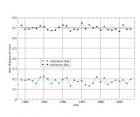
See larger size image here
The finding in this data is that there is no clear evidence of a delay in the start of the later summer/early fall freeze up or the start of the late winter/early spring melt despite the well below average areal sea ice coverage.
A priority in the climate modeling community should be an examination of their predictions of trends in the start of freeze up and start of melt dates, in order to see how they conform to the observational data. Also, the reason that the added atmospheric concentrations of well-mixed greenhouse gases are not changing the dates as expected needs to be provided. Read full post here.