

By Anthony Watts, Watts Up With That
During the the last week, NSIDC graphs of arctic sea ice extent have been dropping so steeply that many have called them into question. Finally NSIDC
ended the daily updates and have left the last “good” image of May 21st in place in the web folder, but have placed an “out of order” sign on the website.
As we first pointed out to NSIDC back on 2/18/09 (even though it “wasn’t worth blogging about") the sensor has been on the fritz for quite awhile, calling the whole arctic sea ice series into question. From their most recent announcement, it looks like that it is now “DOA”.
Here’s what they say now. From NSIDC’s web site: Update: May 26 2009 The daily image update has been temporarily suspended because of large areas of missing data in the past week. NSIDC currently gets its data from the SSM/I sensor on the DMSP F13 satellite, which is nearing the end of its operational life and experiencing intermittent problems.
NSIDC has been working on a transition to a newer sensor on the F17 satellite for several months. At this time, we have more than a year of data from F17, which we are using to intercalibrate with F13 data. The F17 data are not yet available for near-real-time updates. We will resume posting daily updates as soon as possible, either from F13, if the present problem is resolved, or from F17, when the transition is complete.
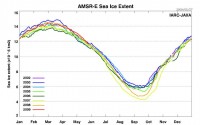
It doesn’t look promising to get any usable data for the last 6 months or more, since it clearly has been corrupted by the sensor issues. Meanwhile the AMSR-E on the Aqua satellite chugs right along on JAXA (below with larger image here).
From NANSEN, here is a map showing differences between AMSR and SSMI. There are some huge chunks missing. (h/t to Fred Nieuwenhuis for the link)
Personally I think it was folly for NSIDC to try to use different channels on the DMSP F13 satellite to nurse the dataset along, as we’ve seen it is not just the single channel on SSM/I sensor that has had problems.
Transitioning to the DMSP F17 satellite “may” be a plan, but the AQUA satellite and the AMSR-E package seems to be quite reliable and with a number of years of life ahead. It is also used by many other agencies to reliably gauge sea-ice.
IMHO, NSIDC is doing themselves no favors by sticking with the DMSP SSM/I satellite platform package. The science world has moved on with AQUA’s AMSR-E, and it is time for NSIDC to move on as well.
Otherwise, they are going to be “has beens” using older technology. Get with the program guys. You need good supporting data so incoming director Mark Serreze can give us his fabulous forecasts and media soundbites that don’t seem to come true.
See full story and comments here.