

By Joseph D’Aleo, CCM, Co-Chief Meteorologist, WeatherBELL Analytics
You can count on it most years about this time. Summers are rarely ‘steady as she goes’. The meanderings of the MJO will cause some dry periods and transient heat in every summer. There is nervousness among farmers at critical times like when the corn is pollinating in July. There are always forecast groups that make the headline by putting a drought gloom and doom scare into the market.
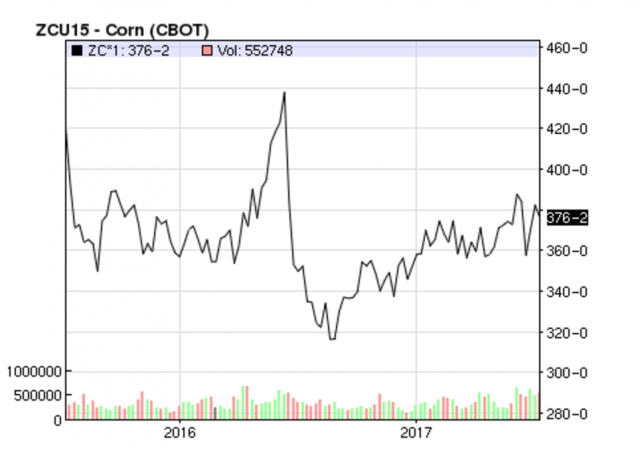
Last year this very time there was a rally based on forecasts of a withering crop due to high heat and futures corn price forecasts of $6+. Two warm days and a spike to $4.40 were followed by showers and cooling and a record crop and low corn prices (below $3.20.). See the current levels far right.

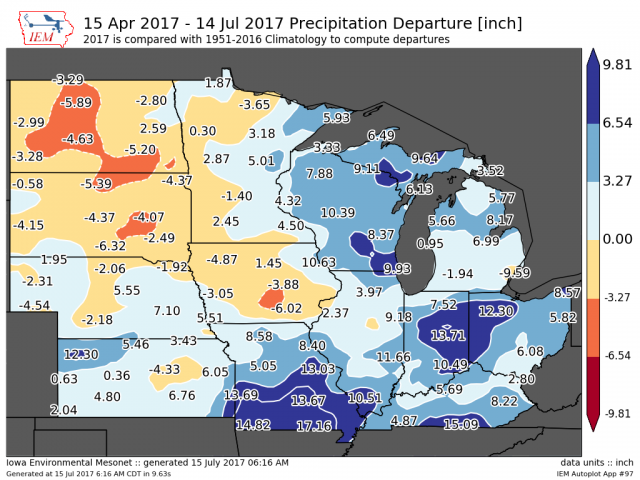
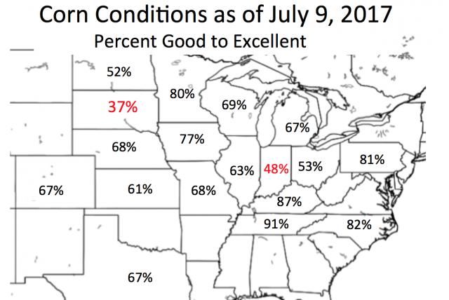
Yes we have been covering almost daily the dryness in the north central that has seriously hurt spring wheat and to a lesser degree corn and beans and made note of the borderline excessive rains in parts of the central Ohio Valley and southern Missouri.
Enlarged (ISU)

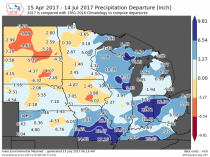
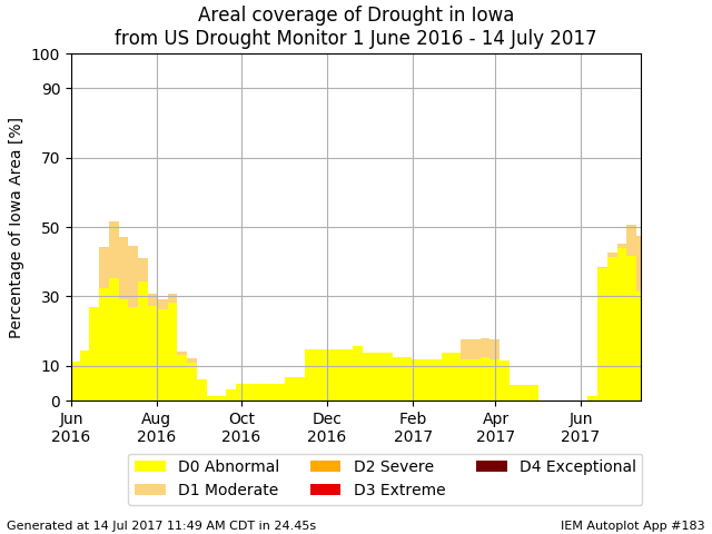
Last year on this date, see the dryness from Iowa through the Ohio Valley.
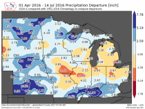
Enlarged (ISU)
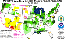
See how the same level of abnormal to moderate drought was reported in southeast Iowa this time of July as is currently the case. Last year, you can see the reason for the concern with the dryness in southeast Iowa into Illinois (the top 2 corn states). Actually a little dryness with an adequate deep soil moisture profile encourages deeper root systems that help plants get by transient heat stress. That was the case last year and is this year in the southern Iowa deficit area.

Enlarged (ISU)
But the heat that worried the market was transient as WeatherBELL forecast and the rains came to all the prime areas. In the eastern Ohio Valley, the late rains made for a better bean crop which is more drought hardy and which has its critical phases in August.
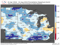
Enlarged (ISU)
James McCune, an Illinois farmer and his team did crop tours for us and he and we and very soon after the USDA NASS predicted a record crop. HIs reports can be found here and here. See how all but the eastern Corn Belt ended up normal to above for rain.The reason they recovered last year and will this year is the seasonal thunderstorm complex season last year did and this year should deliver even into the more serous drought areas of the north central.
Some forecast groups and analysts are warning the heat and ‘drought’ could cause yields to drop to 4 to 5% below long term trend lines and corn prices to spike to $6. We have expressed opinions when asked that the yields will fall short of last year (too dry in the Dakotas and too wet in spots in central Indiana and western Ohio) but with a good crop elsewhere including prime areas of Iowa, Illinois, Wisconsin and Minnesota should be above the trend line.
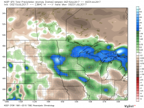
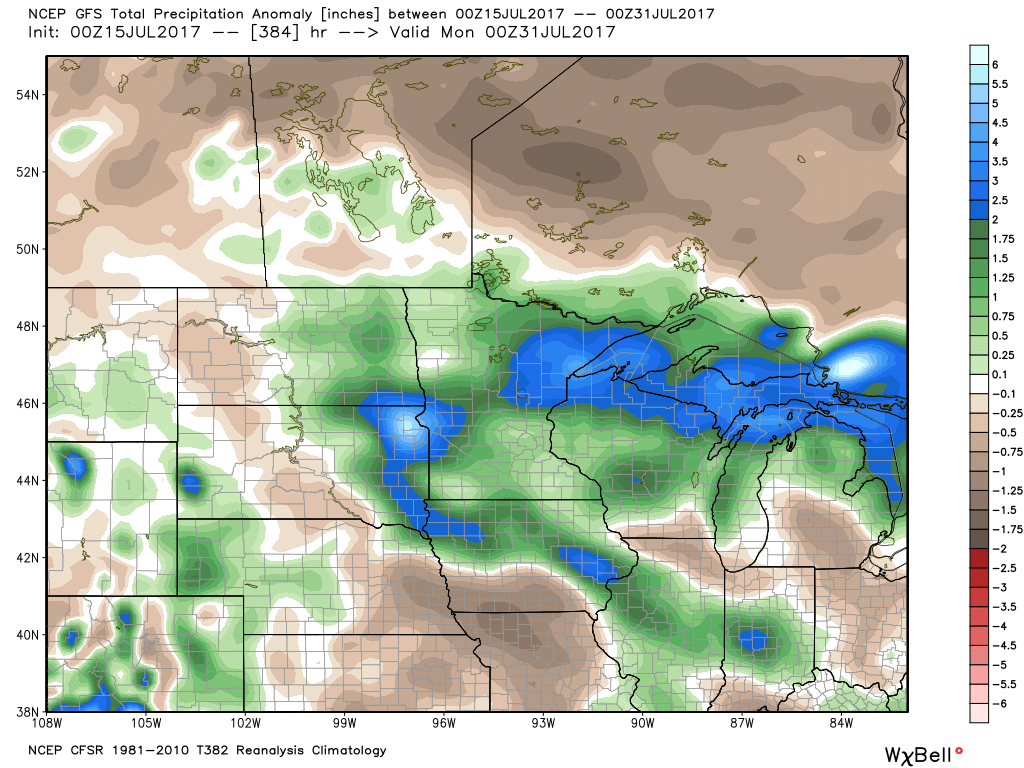
Here is the 16 day forecast of rainfall anomalies. As you can see not all models show the dryness as the forecasters warned. Note on WeatherBell we show the high res, more skillful EC forecast out to 46 days but I can’t show it on general non commercial sites. It is wetter still (and cooler).
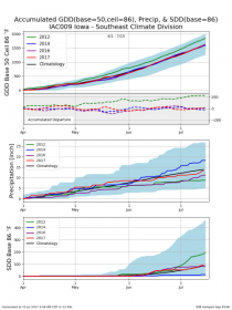
See how southeast Iowa has had normal GDDs and SDD (stress degree days) and slightly below normal rainfall. It is better in thee regards than 2016 at this time there.
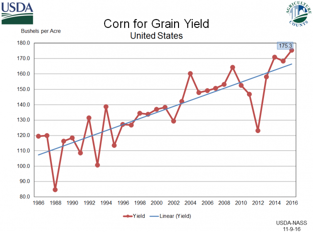
See how yields for corn have increased as the extent of heat has declined, rains have slightly increased and CO2 fertilization (CO2 also reduces water needs).
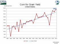
Enlarged (USDA)