


By Joseph D’Aleo, CCM
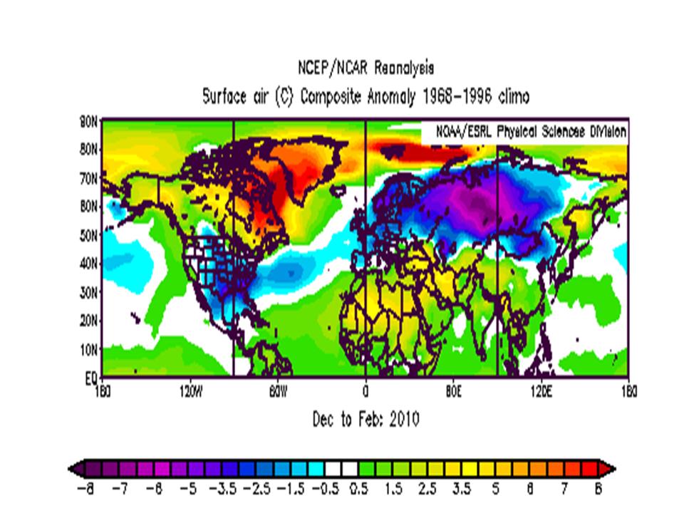
Last winter with a strong El Nino, we had one of the coldest winters (in places like parts of the southeast United States and parts of Siberia, the coldest ever). It was warm though in Canada and the arctic (relative to normal) indicative of strong blocking high pressure.

Enlarged here.
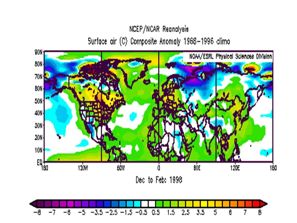
The super El Nino in 1997/98 was very different in most places. It was cold in northwest Russia but much warmer in most other areas it was cold last winter.
Enlarged here.
Why the big difference?
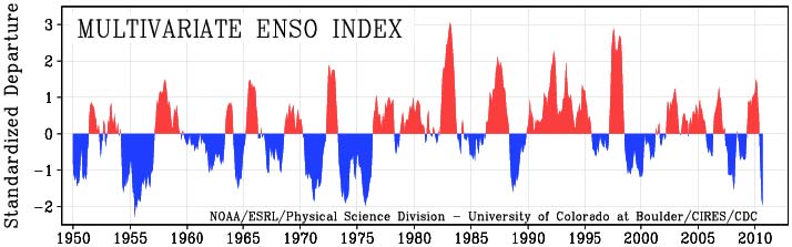
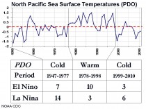
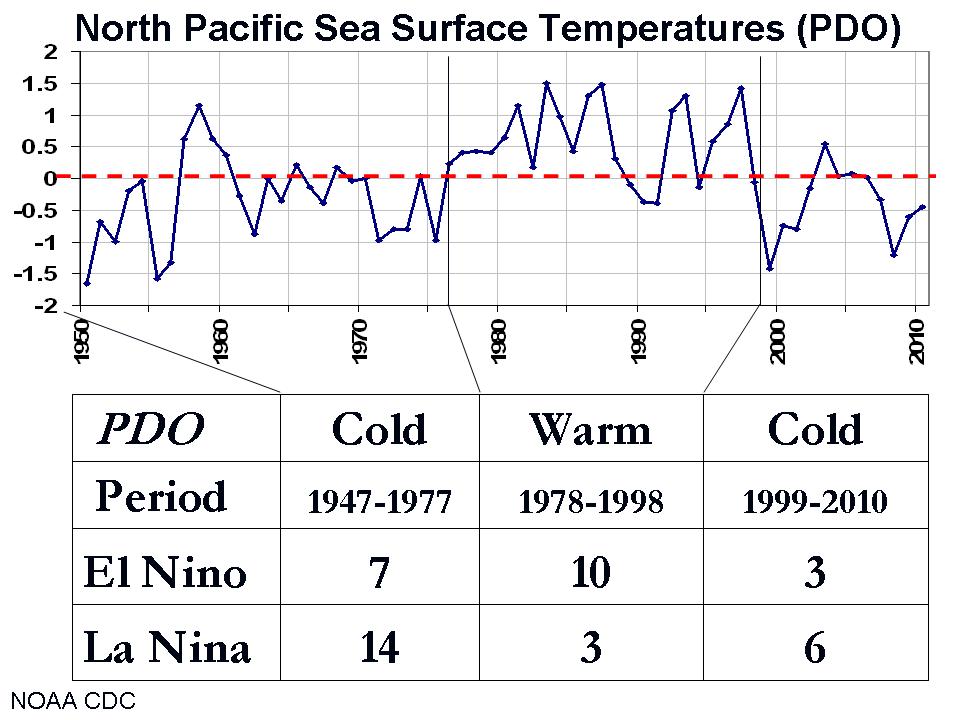
2009/10 was the strongest El Nino since 1997/98 but clearly not as strong as that super event. In many ways, it was more like the El Ninos of the last cold Pacific (PDO) era from 1947 to 1977). The El Ninos were stronger in the warm PDO phase from 1978 to 1998. Wolter’s Multivariate ENSO Index (MEI) shows the big red El Nino spikes of the warm period and the moderate spike of 2002/02 and 2009/10 now in the cold PDO Phase.
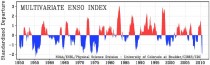
Enlarged here.
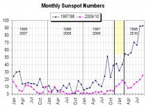
Another very key difference was the solar - the 2009/10 El Nino was during the later part of the ultra-long solar minimum between cycles 23 and 24. 1997/98 winter was much further into a rebound after a much briefer and less deep solar minimum.
Enlarged here.
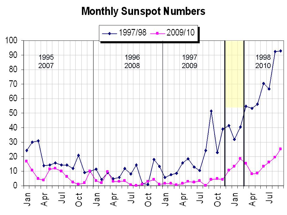
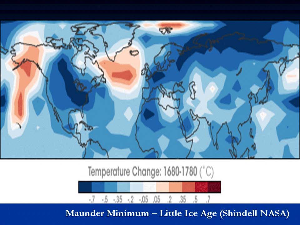
Drew Shindell, NASA modeller who works with James Hansen showed here in a paper in Science (2001) how low solar periods with reduced ultraviolet leads to less ozone chemistry warming in high altitudes over low and mid latitudes. This apparently allows for cooling and expansion of the polar vortex and more blocking in high latitudes (a negative NAO/AO).
Here Shindell shows the difference between the Maunder Minimum temperatures of 1680 and those of much more active sun period 1780. You clearly see the negative NAO and AO and a cold winter in the continents in the low sun period.
Enlarged here.
Writing in Environmental Research Letters (2010), Mike Lockwood et al. have verified that solar activity does seem to have a direct correlation with Earth’s climate by influencing North Atlantic blocking (NAO) as Shindell has shown.
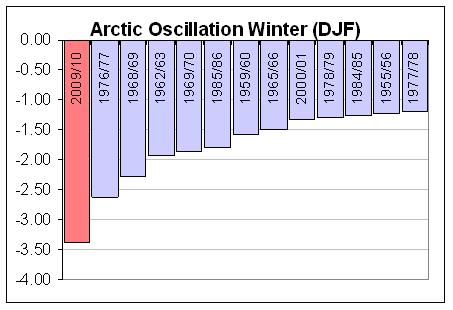
Last winter had a record negative AO/NAO for the winter season, beating out 1976/77 at the end of the last quieter sun period.

Enlarged here.
Labitzke (2001), Baldwin and Dunkerton (2004) and others have shown a tendency for stratospheric warming events in low solar easterly QBO winters (like 2009/10, 1976/77, 1965/66). More on the sun here and here.
Another factor in the anomalous AO was the prior spring high latitude volcanoes in Alaska (Redoubt) and Russia (Sarychev). Oman etal (2003) found high latitude volcanoes lead to enhance winter time high latitude blocking.
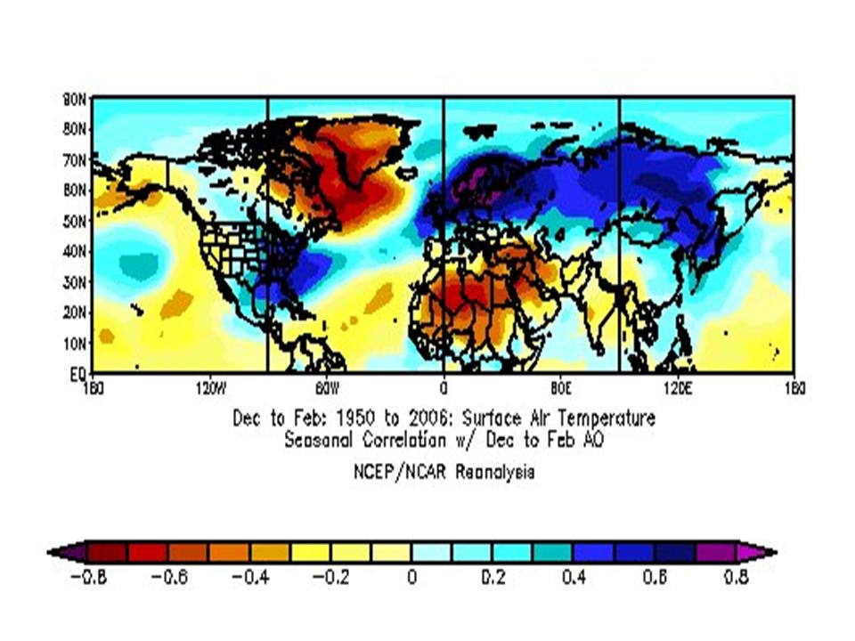
A correlation of the AO (reversed colors to show cold (blues) and warm (reds) for a negative value show the pattern last winter very well.

Enlarged here.
Indeed if we do what Shindell did and subtract the temperatures during the latest low solar El Nino and that of 1997/98 we fit the pattern of 2009/10 and in the correlation to a tee.
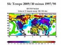
Enlarged here.
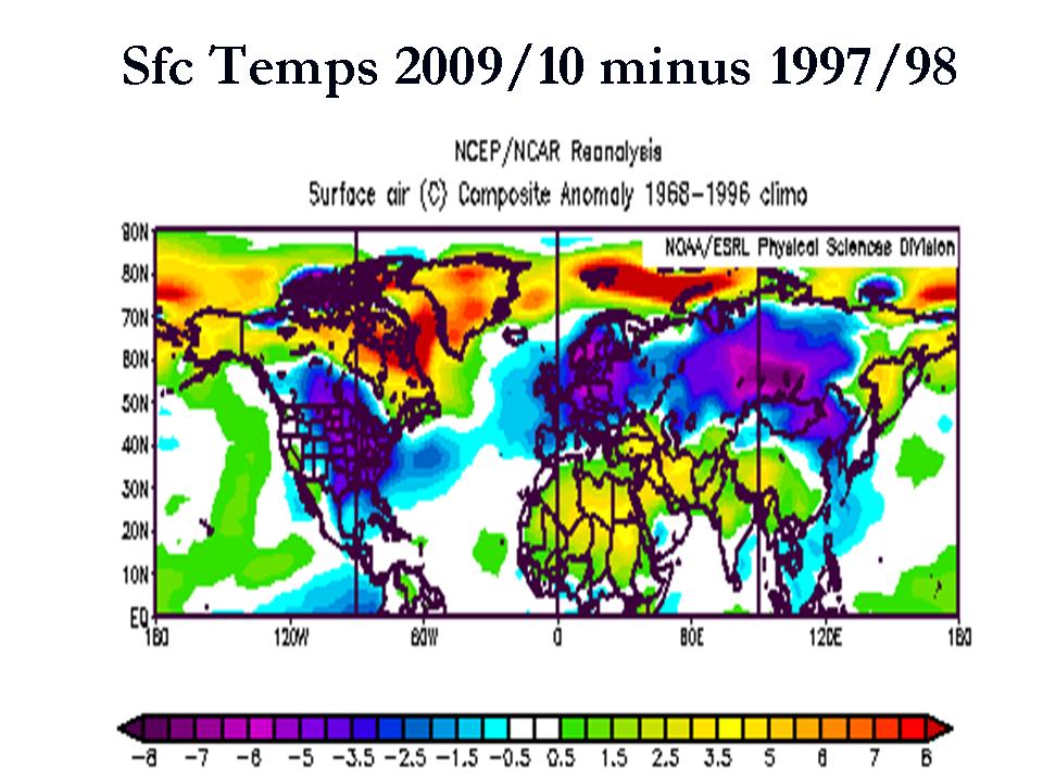
Thus last winter was largely anomalous because the El Nino came along in a year of high latitude volcanoes and in a very quiet sun which led to record high latitude blocking. If indeed we are in quieter sun era, future El Ninos will be more like 2009/10 than 1997/98. They will be less frequent and mainly weaker than they were in the warm Pacific phase.
Enlarged here.
This past summer, El Nino has given way to a strong La Nina and the sun is slowly rebounding. The effects of Redoubt and Sarychev are likely faded but Iceland’s volcano last year MIGHT be having some effect (blocking continues above normal in the higher latitudes). PDF here.
What will that mean for this upcoming winter? An early look was here.
Updated Outlook for the United States for 2010/11 Winter
Update: Hear an interview episode #034 with Andre Bernier of FOX 8 Cleveland on his WeatherJazz site here. FOX8’s Dick Goddard Winter Outlook appears here. Also go to the WBZ TV 4 web site and see the video of the Winter Outlook - which included interviews with Joe Bastardi and Joe D’Aleo
A reversal back to a pattern seen in 2007/08 and 2008/09. Composite of all the winters with similar conditions - La Nina, cold PDO, warm AMO, low solar, westerly QBO yields the following temperature anomalies for December through February.
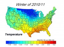
Enlarged here.
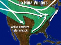
Looks like very cold air will build due to large blocking high presure off the Aleutians making for a very cold winter (more like 2007/08 and 2008/09) in Alaska, Canada and the northern and western United States. The southeast will be warmer this year after a very cold El Nino winter last year. However, there could be a cold frosty outbreak reaching down to Florida, just not the continuous chill.
Storms will tracks along the boundary of the cold air with storms entering the west coast or dropping down from Canada. Many will move up the St. Lawrence Valley bringing snow to the Great Lakes and northern New York State and New England and rain starting as snow or ice further south. Some will run into cold high pressure and be forced to develop off the southern New England coast. They are more likely to mean snow and ICE further south.
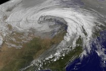
The October ‘Chiclone’ from space. Northern branch systems like this are symptoms of what’s ahead.
Other storms will track out of the Gulf up the Appalachians and these often will do the same, with a secondary storm off the southern New England coast with similar results. The further south these storms develop the more snow wilol fall Boston south. The Mid-Atlantic states where records fell last year will see much less snow but could see some ice. Northern ski areas should do very well, not so much the southern ski areas.
Enlarged here.
You can see the precipitation matching the storm tracks below.
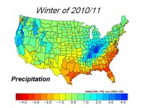
Enlarged here.
The degree and location of blocking high pressure in the Atlantic will determine how much cold and snow in Europe and Asia. South America looks like a cool summer - dry in Argentina. No significant anomalies elsewhere.