By Dr. Madhav Khandekar
Among the extreme weather events of summer 2010, the extensive floods in Pakistan and their widespread impacts garnered maximum attention in the media as well as in the scientific community. Several climate scientists expressed concern about such weather extremes becoming more common with future climate change, while the WMO (World Meteorological Organization) issued a statement that the weather related cataclysms of July and August (2010) fit patterns predicted by climate scientists. The extensive damage due to floods and plight of thousands of people marooned over waterlogged areas were graphically covered in heart-wrenching details by most newspapers and TV news stories in Canada. Per latest estimates, the floods have claimed over 1500 human fatalities so far and over two million more have been rendered homeless.
From a personal perspective, the TV footage of women & children in knee-deep water brought back poignant memories of a similar situation I witnessed in Pune, my former home-town (a city 200 km southeast of Mumbai, the largest Indian city on the west coast) in July 1961 when incessant monsoon rains in the first week of July 1961 led to the breaking of a dam resulting in massive flooding of the city, destroying hundreds of homes and drowning dozens of people living along the riverside. Several other cities and regions suffered from similar flooding during the 1961 summer monsoon. As it turned out, the 1961 summer monsoon over India and vicinity was the rainiest monsoon season in the 150-year instrument data which caused extensive flooding and loss of life and property in many regions of the country (India Meteorological Department 1962). This year’s monsoon has been quite vigorous since the third week of July 2010 and heavy rains have caused flooding in the peninsular regions of India and also in the northwest regions bordering with Pakistan. Has the vigorous Indian monsoon of 2010 led to the historic floods in Pakistan? Let us briefly consider the monsoon climatology.
Floods & droughts in the Indian monsoon
It should be noted first that the monsoon season in Pakistan is almost in tandem with the Indian monsoon, which is primarily driven by regional as well as global scale features like the ENSO (El Nino-Southern Oscillation) phase, Eurasian snow cover during the (previous) winter season and the QBO (Quasi-Biennial Oscillation) phase of the equatorial stratospheric wind oscillation (see e.g., Khandekar 1996). The monsoon season in Pakistan is generally of a shorter duration, from about 1st of July till about third week of September. Pakistan as a whole receives just about 50 cm (~ 20 inches) monsoon rains,
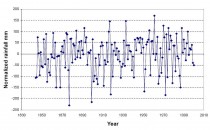
compared to about 85 cm for the whole of India during the June-September season. Based on an excellent dataset of close to 150 years, some of the most severe floods and droughts in the Indian monsoon have been identified as shown in Figure 1. This figure shows how the floods and droughts have occurred irregularly throughout the 150-yr period and do not appear to reveal any increasing/decreasing trend. As mentioned earlier, the 1961 summer monsoon was the rainiest with extensive flooding while the year 1877 witnessed the most severe drought with over 40% deficit in total seasonal rains.

Figure1: Variability in the Indian summer monsoon rainfall, 1844-2000, with seven major droughts (1868, 1877, 1899, 1918, 1951, 1972 and 1987) and six major floods (1892, 1917, 1933, 1961, 1970 and 1975) as shown.
Among other droughts and floods, the monsoon rains were exceptionally heavy in 1917 with extensive floods over many areas of the country, while 1972 was a major drought year resulting in sharply reduced grain yields. The decade of the 1930s experienced in general surplus rains over most of India with three flood years, namely 1933, 1936 and 1938 (Bhalme & Mooley 1980). It is of interest to note that the 1930s were part of the dust bowl years on the Canadian/US Prairies. A possible teleconnective link between Indian monsoon flood and Canadian Prairie drought has been speculated by Khandekar (2004).
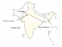
Besides these floods and droughts occurring irregularly, the inter-annual variability of monsoon shown in Figure 1 reveals several consecutive years with a flood following a drought. For example, the years 1941, 1972 and 1987 were drought years, while the following years 1942, 1973 and 1988 were flood years. Such a flood-drought sequence seems to suggest a biennial mechanism for the Indian monsoon driven by large-scale atmosphere-ocean circulation patterns and has been analyzed by Terray (1987) among others. The primary mechanism driving such back-to-back flood & drought monsoon seems to be the ENSO phase and its evolution from an El Nino (warm) event to a La Nina (cold) event. The years 1941, 1972 and 1987 were El Nino years, while the succeeding years 1942, 1973 and 1988 were La Nina years. An El Nino event helps suppress convective activity over the Bay of Bengal region (Francis & Gadgil 2009) where from moisture is transported towards the northern Gangetic Plains region and further into northwest India along the Axis of Monsoon Trough which by July is established in a southeast-northwest track from the Bay of Bengal to the northwest region of India bordering Pakistan. (see Figure 2). A few monsoon depressions in the Bay of Bengal help transport moisture in the northwest regions of India and occasionally into Pakistan during the active period of the monsoon season, approximately from early July through mid-August.
Possible cause of flood in Pakistan & northwest India during 2010
The El Nino event of 2009, which produced one of the warmest winters in Canada, was coming to an end by spring 2010. By June 2010, a La Nina (cold phase of ENSO) was developing in the equatorial Pacific, which became intensified by early July. In response to this developing La Nina, the convection over the Bay of Bengal was enhanced and several monsoon depressions helped steer the monsoonal flow into the northwest parts of the Indian subcontinent. During the third week of July 2010, a persistent low pressure over the State of Rajasthan in the northwest part of India helped steer additional moisture into northwest Pakistan resulting in heavy rain events and subsequent flooding. Similar flooding occurred in the Indian States of Rajasthan, Punjab and Kashmir which are adjacent to Pakistan. Per latest statistics (as of August 25 2010), from the India Meteorological Department, the
seasonal rainfall over the northwestern Indian States has already exceeded 125% of the normal.

Figure 2: Outline map of India and Pakistan showing normal July position of monsoon trough axis.
It is worth noting that in a given monsoon season, localized and/or regional flooding can occur in some parts of the Indian subcontinent, while some other parts may be suffering from rain deficit at the same time. Such surplus/deficit rain patterns are an integral part of the monsoon season which rarely ever produces evenly distributed rainfall in a season. During the rainiest monsoon season of 1961, central India received about 30% more rain than normal, while the northeast region (where the world’s wettest spot Cherrapunjee is located) the seasonal rains were in deficit by 25%.
Concluding Remarks
A rapid transition of the ENSO phase from El Nino to La Nina between spring and summer of 2010 appears to be the key element in triggering a vigorous monsoon of 2010 over the Indian subcontinent. The La Nina phase was responsible for enhanced convective activity over the Bay of Bengal where several monsoon depressions were formed. The depressions while traveling along the axis of monsoon trough carried sufficient moisture towards northwest leading to extensive flooding. Local and regional factors like topography may have exacerbated the impact of floods in some areas. An examination of monsoon climatology as revealed by Figure 1 suggests that the 2010 Pakistan floods, although seemingly unprecedented, were well within natural variability of monsoonal climate over the Indian subcontinent. As I have suggested before (Khandekar 2009), there is an urgent need for an improved understanding of many complex features associated with the Indian/Asian monsoon system. An improved understanding may enable us to improve monsoon predictability, thereby minimizing adverse future impacts of such floods and droughts. See more here.


