


By Joseph D’Aleo, CCM
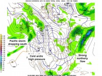
As I write this it is the coldest morning of the winter so far with single digit to sub-zero temperatures across the north from Iowa, Illinois and Missouri east to Pennsylvania, New York and New England. The coldest reading on the map appeared to be -20F in Saranac Lake, NY. The cold extended deep into the south with freezing temperatures to Fort Myers (a record low)and a chilly 39 in Miami and 45 in Key West. Readings were in the high 20s to low 30s across the growing areas, likely doing some damage to vegetables but it appears damage to citrus was minimal. There were even snow flurries in Daytona Beach.
See larger image here
After a frigid day, a moderation will spread from the central states where it begins tomorrow to the east coast this weekend. Temperatures for the early into the middle part of next week will be much above normal in the central and east. There could be some records set. In New York City, it will reach the 60s. Most every day in January has had record highs in the 60s and even 70s (in 1932, 1950 and 2007). Cold will start returning later in the week.
Read more on the causes for the swings and what might lie ahead here.