


By Joseph D’Aleo, CCM
A warm wedge of air that brought rain and very mild temperatures even to the nation’s midsection for a day this weekend and to the east today will be moving off the coast today and cold arctic air will again follow. You can see it beginning to pour into the northern plains now.
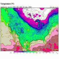
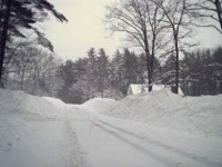
It will like most of the arctic air the last two months focus most in the central states to start but will be felt to a greater extent further east in a day or so with less of the moderation seen with earlier outbreaks. As is typical in many La Nina years, the cold can expand more into the east and the storms that were mainly snow early and mainly a messy mix or rain of late will tend back towards snow again as we move towards and into March. The last La Nina in 2000/01 brought very heavy snows to much of the country in November and December and then parts of the northeast late in the winter. This was my street in central New England in mid March of 2001 after two successive 24 inch snowstorms. Not promising the same this year, but I do expect more snow reaching the northeast just as it did early.
Regardless this winter will be one of the snowiest winters in some time for the nation as a whole although many in the Mid-Atlantic up to southern New England have felt left out (or overjoyed if you dislike snow). You will probably get some late chances here in the weeks ahead along with many other areas that were hoping winter would go away quietly (see snowfall map of the midwest develop by the ISU Mesonet here).