


PUBLIC INFORMATION STATEMENT
NATIONAL WEATHER SERVICE ANCHORAGE AK
411 PM AKDT SAT APR 7 2012
..ANCHORAGE MAKES HISTORY WITH A RECORD SNOWFALL SEASON
AS OF 4 PM AKDT SATURDAY AFTERNOON...3.4 INCHES OF NEW SNOW HAS FALLEN SINCE MIDNIGHT. THIS MAKES THE 2011-2012 WINTER SEASON THE SNOWIEST EVER WITH A TOTAL OF 133.6 INCHES. THE PREVIOUS SEASONAL SNOWFALL RECORD WAS 132.6 INCHES SET IN 1954-1955.
This analysis below was compiled a few dayts ago by John Papineau, climatologist at the Anchorage office of the National Weather Service with photo by NASA Earth Observatory.
--------------------
As of April midday April 7 we have received 131.7 inches of snow making it the second snowiest winter, (just 0.9 inches below the all-time record) and the season isnt over. Blowing snow and icy roads at times have made for some challenging driving. Snow berms have limited vision, particularly along narrow snow-choked side streets.
Nevertheless it has been a boom season for snow removal contractors and auto body repair shops. Skiers enjoyed a season of plenty when it wasnt windy, rainy or locked in a deep freeze of sub-zero temperatures.
Normal winter: 75 inches of snow
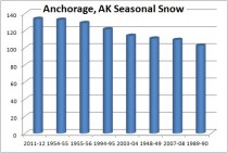
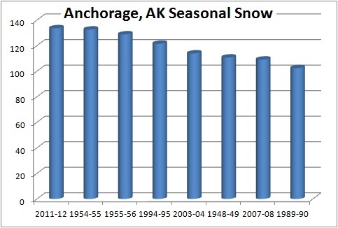
Eight Anchorage winters have seen snowfalls exceeding 100 inches, topped by the 1954-55 total of 132.6. Those measurements have been taken at a number of locations throughout the years. From 1998 to the present snowfall and snow depth has been measured at the National Weather Service Office, located just south of the airport. From 1953 through 1998, snow measurements were taken at Point Campbell, located on a knoll adjacent to the east-west runways at the airport. Before 1953, observations were taken at Merrill Field and various spots downtown. Some of these locations are windier than others during the winter, so there is some geographic variability—but the current location and Point Campbell are close enough for one continuous record.
The current 30-year mean Anchorage snowfall is 74.5 inches. Going back a full 81 years, the mean is 68.7 inches. Prior to 1953, snowfall was less than recent decades for some reason. Whether the difference is due to the location of the observations, or an actual change in snowfall, is unknown.
But no matter how you look at it, this winter was white—not only in Anchorage but throughout Southcentral and across much of Alaska. Although the official snowfall measurement is taken in west Anchorage, snow depth varies greatly across town. On the upper Hillside for example several locations have measured more than 200 inches of snow this season.
It all began Oct. 30 when the snow season got off to a humble start with 1.1 inches at the National Weather Service forecast office. Snowfall has been fairly consistent all winter. The longest dry stretch in mid-winter was a 10-day stretch during the mid-January cold spell. Currently we are in a 22-day drought.
Snow reached its greatest depth of 36 inches in late February and early March. As deep as that is, its not close to the record of 47 inches on Dec. 31, 1955. A year later in February and again in mid-March of 2002, the depth reached 39 inches.
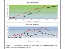
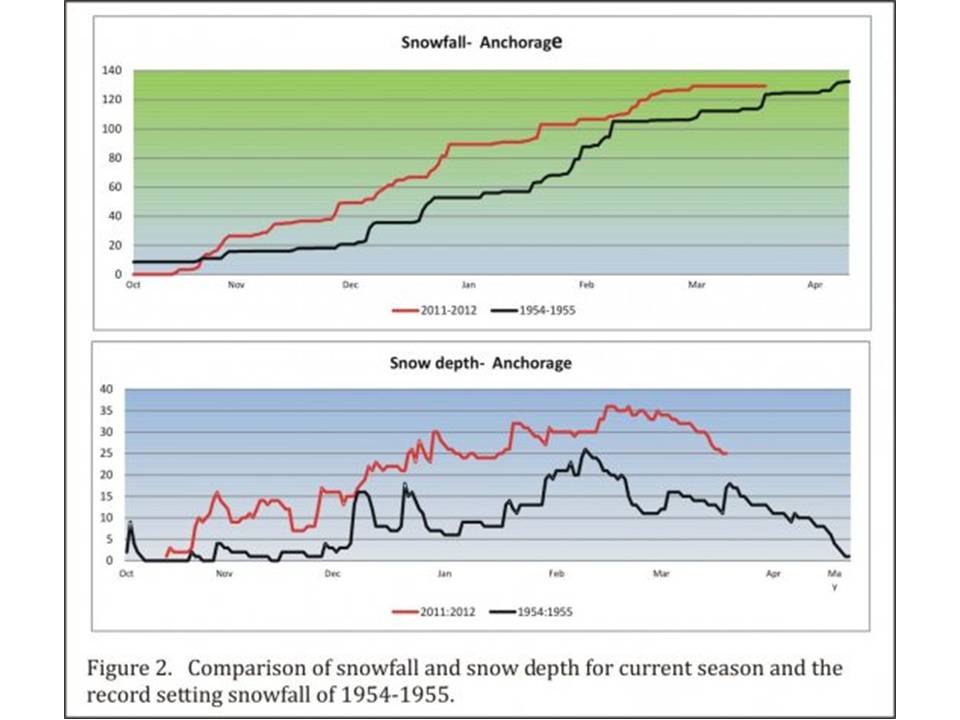
Figure 2 shows the month-to-month ‘path’ that the record snowfall took in comparison with the previous record of 1954-1955. Snow started later this season but outpaced the old record by early November. Only since mid-February have the two been close.
It is apparent that this winter shares characteristics with previous big snow years—most snow came in small increments rather than in large doses. A comparison of the number of snow days, defined as any day with at least 0.1 inches of snowfall, and the number of days where 6 inches of more snow fell.
Astute readers will noticed that three of the highest snowfall totals shown in Figure 1 have occurred in the last nine seasons. This begs the question whether we are experiencing an increase in snowfall or precipitation. There does not appear to be any trend in the data at this point, but its worth monitoring.
Historical data indicates no correlation between the occurrence of an El Nino or La Nina and the amount of snowfall in Anchorage. It is noteworthy that both the heavy snow seasons of 1954-1955 and 1955-1956 were La Nina winters. However, since the North Pacific climate shift of 1977, there has been 10 La Nina’s with an average snowfall of approximately 78 inches. There have been 11 El Nino events since 1977 producing an average of 74 inches of snow. Weather patterns during a given El Nino or La Nina in the greater Alaska region are less predictable than they are in the mid-latitudes due to the highly unstable positioning of the storm track across the southern Bering Sea and Gulf of Alaska.
In fact, of the 10 wettest (snow plus rain) winters since 1977 in Anchorage, three occurred during La Nina winters, three during El Nino’s winters and four during neutral winters. The primary difference between La Nina’s and El Nino’s is that there is a higher probability that a La Nina winter will be cooler than an El Nino winter.
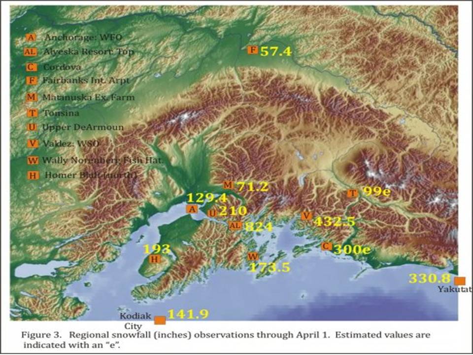
Heavy snow throughout region
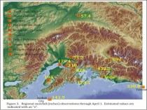
Figure 3 shows snowfall around the region; virtually all locations south of the Alaska Range have received well above normal amounts. Kodiak is close to setting a new snowfall record. Valdez has gotten lots of snow but is well behind its record of 550.7 inches set in 1989-1990. Although snowfall in Yakutat has also been well above normal, it is still some ways from its record of 403.2 inches set in 1975-1976.
Despite several days in the 40s recently, our snow season isn’t over yet, so who knows how much more we could receive over the next several weeks.
What many residents are wondering is how long will it take for all this snow to melt? Although snowmelt began in earnest this past week, it could take a while. The most significant factor is the speed at which air temperatures warm in April. Second in importance is sunshine.
Sometimes the warming is abrupt and the snow melts rapidly, as in late March of 1995. Other years are slow and the snowpack bleeds off, as happened in April 2002. One advantage to abundant November snowfall is that it insulated the ground. So despite the deep snowpack, once everything melts, the frost depth should be less deep that in many years—meaning that the ground should warm fairly rapidly.
The current estimate of frost depth in Anchorage is around 15 inches; although frost depth data is very limited, this is indeed much shallower than what we would measure in a typical winter.
If we look at the melt-out dates (just a trace of snow remaining at the Forecast Office) of several of the big snow years, we see a wide range of dates. The advantage of an abrupt warming trend in spring is that the snow melts sooner and the frozen ground can begin to thaw.
The disadvantage is that all the water forms ponds in low-lying areas. That makes for fun - or challenging - driving. Some of these melt ponds refreeze overnight, making for even more fun the next morning.
Nearly 2 feet in late April
Note that in April of 2008 the snow in west Anchorage had melted out—but on the 25th a major snow storm produced another 15-22 inches across town. That pushed the ultimate melt out back to April 30.
It may not be over
Those who think we’re done with snowfall for this winter should note that more than 18 inches of snow fell in April of 1955 to set Anchorage’s snowfall record. While the average snowfall for April is around 4 inches, it can range between 0 and 30 inches.
Surprisingly, much of this season’s snow fell during cold stretches. As a rule of thumb, warm air—when the temperature near the ground is in the 20s to lower 30s—is more conducive to snowfall than chillier temperatures. If we look at how much snow fell when the daily mean air temperature was 10 degrees F or colder during other heavy snow seasons we find:
16.5 inches fell in 1954-1955;
11.5 inches in 1955-1956;
12.8 inches in 2007-2008.
However, this season 31.1 inches of snow fell on especially cold days. Why is a mystery at this point—but since this winter has been a tale of extremes throughout much of Alaska, we shouldn’t be too surprised.
Enlarged.
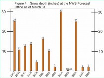
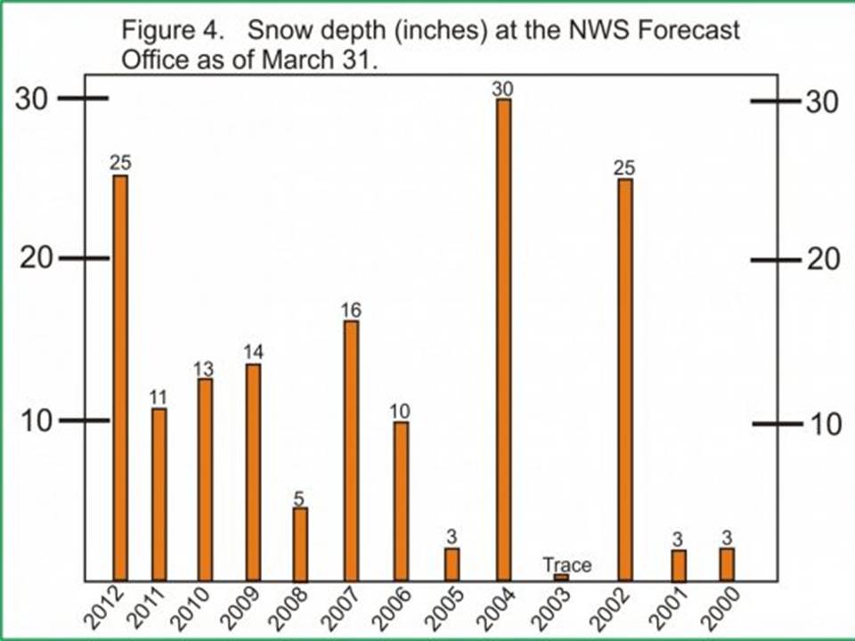
Figure 4 shows the snow depth on March 31 for the previous 12 years. Note that the current snow depth of 25 inches contains 6.4 inches of water, which means that if this amount of snow was suddenly melted it would release this much water. The range is from zero to 30 inches so our current value is on the high side but not extreme.
So what produced all the snow? Weather maps produced over the course of the winter indicate the storm track across the eastern North Pacific was shifted farther north than in most winters. Why is anybody’s guess, but the result was more storms in the Gulf of Alaska—with fewer reaching the western Lower 48 states.
Look at how many days brought rain or snow to the Gulf of Alaska coast from January through March. In Yakutat, typically 59 out of 90 days bring some precipitation—rain or snow. This past season saw 78.
The number of snow days during this three month period averages 38 days; this season had 61 days. During years of heavy snowfall, the increase is typically due to an increase in the number of storms rather than more snow from the same number.
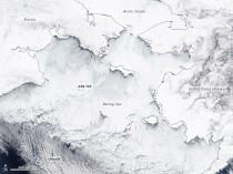
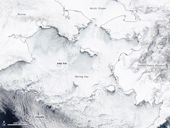
See the ice in the Bering Sea from NASA Earth Observatory.
Enlarged.
The extensive ice coverage here helped the arctic ice extent exceed the 1979-2006 average for the first time in many years.
Also note:
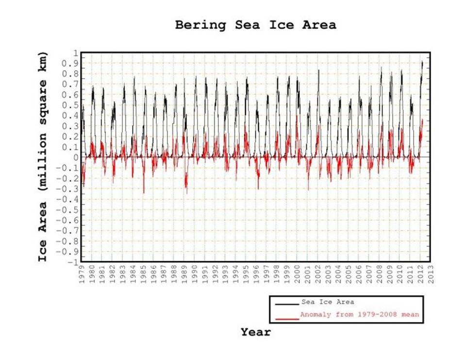
Alaska Has The Most Ice Ever Recorded
by Steven Goddard
Alaska has blown away all records for sea ice this winter. Four of the five iciest years around Alaska have been since 2007. Look for the MSM to respond by publishing stories about drowning Polar Bears who can’t find any ice.

--------------------
Moscow gets slammed with spring snowstorm
MOSCOW: Muscovites on Thursday woke up to a blanket of snow covering the Russian capital after a powerful cyclone brought a winter storm in the middle of spring.
“Last night a small but powerful cyclonic whirl hit the capital at a speed of 50 kilometres (31 miles) per hour bringing with it copious snowfall,” weather forecaster Fobos said.
“On the morning of April 5 Moscow has become white once again,” the weather forecaster said, adding however that frequent weather changes were fairly typical in the country in April.
Temperatures in the afternoon were expected to go up to two degrees Celsius (36 degrees Fahrenheit).
The snowstorm comes as a major test of patience for Muscovites who have endured an unusually cold and long winter lasting five months. Russians consider that spring begins on March 1.