


By Joseph D’Aleo
Mother Nature for the second year in a row is sending a message to alarmists in the government and the media.
Another snowstorm has swept across the nation and focused its fury on the northeast corrdior. Last year it was the Mid-Atlantic, the political center that was ground zero. This year ground zero is further north from New York City (the nation’s media center) into southern New England. In Connecticut, Hartford has had the snowiest January and month ever.
Snowcover in the northeast is extensive and deep with 2 feet in many areas (below, enlarged here).
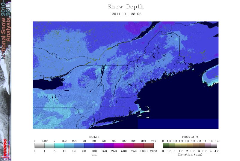

Since Dec. 14, snow has fallen eight times on the New York region - or an average of about once every five days.
In New York City, the third major snowstorm dropped 19 inches, the 8th heaviest snowstorm in history (back to 1869/70).
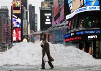
(Times Square, Thursday January 27, 2011 - AP Photo, Mark Lennihan - ABC Eyewitness News)
The post Christmas blizzard brought dropped 20 inches, the sixth heaviest snowstorm. The blizzard paralyzed travel after Christmas. Mayor Michael Bloomberg, who suddenly has become interested in tracking how much snow falls after the city was slow to deal with the post Christmas blizzard, said it was the snowiest January since the city started keeping records, besting 27.4 inches set in 1925.
Earlier in 2010 on February 25-26th, the 20.9 inches was enough to put it in fourth place among Central Park snow events.
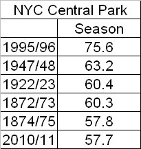
A storm on the 10th and 11th of January brought 9.1 inches. So far 56.1 inches has fallen which puts 2011 already in 6th place among all years since snow records began. The 36 inches for the month is just 0.9 inches short of an all-time monthly snow record (set last February). A few clippers the next two days may break that record.
Hartford, Connecticut had 57 inches in January alone (71.2 inches for the season). This was for Hartford the snowiest January on record beating out the 43.1 inches in 1996 and also the snowiest month beating the 45.3 in 1945. See snow pictures from Connecticut here.
More light snow events and continued cold temperatures is forecast the next 5 or 6 days. Aother storm will threaten next Wednesday and Thursday that could move the year into second or third place. This season seems destined to eventually surpass 1995/96.
The media has been trying to find a way to blame global warming for the snow. Actually a rapid COOLING (the UAH January global number may be negative, down almost a whole degree F since the warm peak after the El Nino during 2010) is likely to blame. The cooling the last several months may be the most significant of the satellite record. Clouds and precipitation always result from cooling processes. The cooling, as we have posted, is likely due to a Pacific that has turned cold, a La Nina, continued slow ramp up of feeble solar cycle 24 and a series of high latitude volcanoes that together with a quiet sun and a warm Atlantic helped support high latitude blocking high pressure (a negative Arctic Oscillation - the most negative on record last winter and continued negative most of the first 8 weeks this winter).
This video from last night gives you the flavor of the NYC snow although at one time there was lightning and thunder and near zero visibility snow. The video is a little jumpy. Please send photes or video links to me at jsdaleo@yahoo.com and I will add.