


By Anthony Watts, Watts Up With That
We have news from the National Snow and Ice Data Center (NSIDC). They say: The melt is over. And we’ve added 9.4% ice coverage from this time last year. Though it appears NSIDC is attempting to downplay this in their web page announcement today, one can safely say that despite irrational predictions seen earlier this year, we didn’t reach an “ice free north pole” nor a new record low for sea ice extent. Here is the current sea ice extent graph from NSIDC as of today, notice the upturn, which has been adding ice now for 5 days:
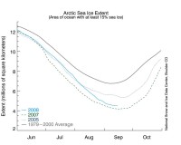
Here is what they have to say about it: “The Arctic sea ice cover appears to have reached its minimum extent for the year, the second-lowest extent recorded since the dawn of the satellite era. While above the record minimum set on September 16, 2007, this year further reinforces the strong negative trend in summertime ice extent observed over the past thirty years. With the minimum behind us, we will continue to analyze ice conditions as we head into the crucial period of the ice growth season during the months to come.
Despite overall cooler summer temperatures, the 2008 minimum extent is only 390,000 square kilometers (150,000 square miles), or 9.4%, more than the record-setting 2007 minimum. The 2008 minimum extent is 15.0% less than the next-lowest minimum extent set in 2005 and 33.1% less than the average minimum extent from 1979 to 2000.
Determining with certainty when the minimum has occurred is difficult until the melt season has decisively ended. For example, in 2005, the time series began to level out in early September, prompting speculation that we had reached the minimum. However, the sea ice contracted later in the season, again reducing sea ice extent and causing a further drop in the absolute minimum.
We mention this now because the natural variability of the climate system has frequently been known to trick human efforts at forecasting the future. It is still possible that ice extent could fall again, slightly, because of either further melting or a contraction in the area of the pack due to the motion of the ice. However, we have now seen five days of gains in extent. Because of the variability of sea ice at this time of year, the National Snow and Ice Data Center determines the minimum using a five-day running mean value.
In addition, NSIDC will issue a formal press release at the beginning of October with full analysis of the possible causes behind this year’s low ice conditions, particularly interesting aspects of the melt season, the set-up going into the important winter growth season ahead, and graphics comparing this year to the long-term record. At that time, we will also know what the monthly average September sea ice extent was in 2008 - the measure scientists most often rely on for accurate analysis and comparison over the long-term.”
It will be interesting to see what they offer in the October press release. Plus we’ll be watching how much ice we add this winter, and what next year’s melt season will look like. Hopefully we won’t have a new crop of idiots like Lewis Gordon Pugh trying to reach the “ice free north pole” next year. Read more here.