


NOAA versus NASA: US Data
By Steve McIntyre, Climate Audit
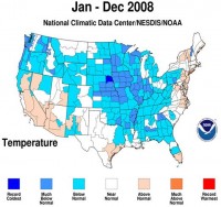
Anthony has a post reporting NOAA’s 2008 results, with NOAA reporting:
For 2008, the average temperature of 53.0 degrees F was 0.2 degree above the 20th Century average.
Enlarged map here.
Anthony showed the following image from NOAA (enlarged here):
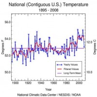
Readers need to keep in mind that there is a substantial “divergence” between NOAA US and NASA US temperatures as shown in the graphic below. Since 1940, NOAA’s US has increased relative to NASA’s US at a rate of 0.39 deg C/century, thus 0.27 deg C since 1940.
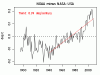
Figure 2. Difference (deg C) between NOAA US and NASA US temperature anomalies (enlarged here).
At present, we don’t know very much about the NOAA calculation. To my knowledge, they make no effort to make a UHI adjustment along the lines of NASA GISS. As I’ve mentioned before, in my opinion, the moral of the surfacestations.org project in the US is mainly that it gives a relatively objective means of deciding between these two discrepant series. As others have observed, the drift in the GISS results looks like it’s going to be relatively small compared to results from CRN1-2 stations - a result that has caused some cackling in the blogosphere. IMO, such cackling is misplaced. The surfacestations results give an objective reason to view the the NOAA result as biased. It also confirms that adjustments for UHI are required. Outside the US, the GISS meta-data on population and rural-ness is so screwed up and obsolete that their UHI “adjustment” is essentially random and its effectiveness in the ROW is very doubtful. Neither NOAA nor CRU even bother with such adjustments as they rely on various hokey “proofs” that UHI changes over the 20th century do not “matter”. See post here.
----------------------
December 14th Coldest, 11th Wettest for the United States
By Joseph D’Aleo
Note: Key West came within 1 degree of their all time record low with 42F. The coldest was 41F set in 1981 and 1886. In a southwest suburb of Miami (West Kendall Airport), it dropped to 26F this morning.
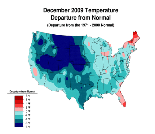
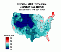
The average temperature in December 2009 was 30.2 F. This was -3.2 F cooler than the 1901-2000 (20th century) average, the 14th coolest December in 115 years. The temperature trend for the period of record (1895 to present) is 0.1 degrees Fahrenheit per decade (enlarged here).
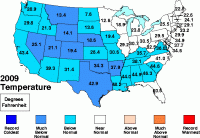
See state by state ranking below (enlarged here).
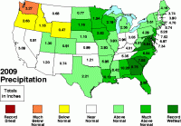
2.88 inches of precipitation fell in December. This was 0.65 inches more than the 1901-2000 average, the 11th wettest such month on record. The precipitation trend for the period of record (1895 to present) is 0.02 inches per decade (see enlarged here).
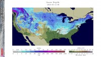
After a cold first half of January, a “January thaw”, a singularity that appears most reliably in cold winters around the third week of January will overpread much of the nation the next week before cold weather returns late in the month. Snowcover will slow the surface warming (see enlarged here).
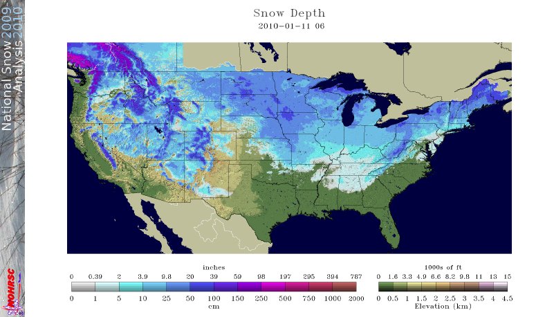
Globally, the snowcover is well above normal. (see enlarged here).
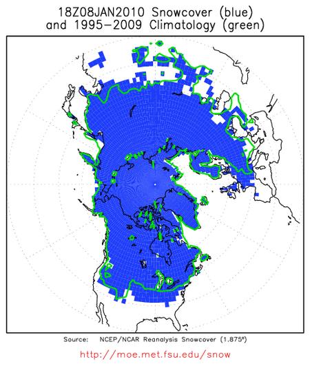

Enlarged here.
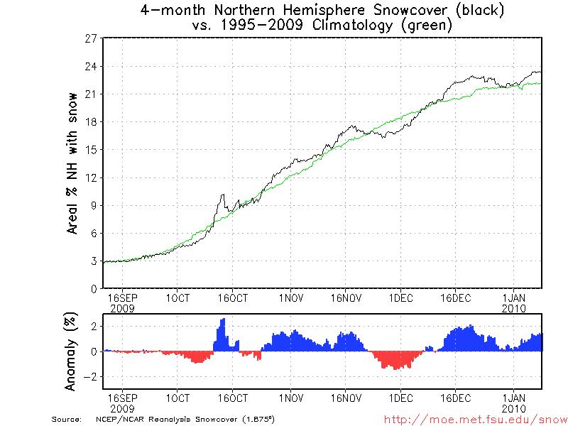
As often happens in winters when major blocking - arctic warming (negative AO) occurs in December, it eases briefly allowing for a more zonal flow and some brief moderation in the United States, western Europe and China for a few days then repeats again in mid to late winter. After this ‘January thaw the next week or so, expect more December like cold and snow, to reprise by late January and February. That should ensure the winter of 2009/10 will for these locations average among the colder winters in quite a while, even with the cooked data sets.
The Global Data for December and 2009
NOAA tells us: “The globe recorded its eighth warmest December since record keeping began in 1880, and 2009 tied with 2006 as the fifth warmest year on record, according to NOAA’s National Climatic Data Center. NASA’s Goddard Institute for Space Studies rated December 2009 as the 4th warmest December on record, and the year 2009 tied with 2007 as the second warmest year on record (in 135 years. NOAA rated December 2009 ocean temperatures as the 2nd warmest on record, next to 1997, and land temperatures as the 31st warmest on record. The anomalously cool conditions over much of northern Asian and North American land areas may be associated with the near record December snow cover extent over Northern Hemisphere land areas--2nd most on record, behind 1985. Snow cover records go back to 1967. The December global satellite-measured temperatures for the lowest 8 km of the atmosphere were the 7th warmest on record (in 31 years), according to the University of Alabama Huntsville and RSS data sets.