


By Joseph D’Aleo, CCM, Fellow AMS
With some of the coldest weather since 2000 or even 1989 coming to the United States, Western Europe and Eastern Asia for December, I thought this story I did for Intellicast.com might be of interest to those with a weather interest.
East coast cyclones in winter can produce prodigious snowfalls burying the major cities of the east. They come in different flavors - as waves along fronts offshore or as storms that develop secondary to inland lows.
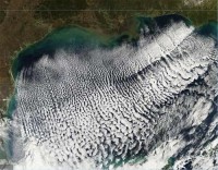
My Masters Thesis at the University of Wisconsin was on Explosive Development in East Coast Cyclones. In that study I found the most common precursor was a cold outbreak into the Atlantic ahead of the trough and storm development. This generates a considerable reservoir of available potential energy that gets released when the upper conditions become more favorable. You can see visible signs of this with the clouds that form in the cold air stream off the coast over the warmer water.
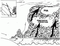
This vertical development is limited by subsidence in the negative vorticity advection (NVA) area ahead of the short-wave ridge between systems.
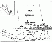
This produces an inversion that acts as a lid on vertical motion. After the passage of the short wave ridge and the start of positive vorticity advection, the lid is removed and penetrative convection begins. Often this takes the form of thunderstorms which transfer sensible and latent heat into the storm and help pressures fall rapidly. Pressure falls of up to 40mb in 24 hours have been recorded.
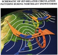
The dynamics of the upper systems of course play a role in how much development occurs. Kocin and Uccellini in their wonderful two volume monograph available from the AMS discussed the schematics of the jet stream circulation in many or most east coast cyclones.
In my thesis, one of my case studies was the storm of March, 1960, shown in the linked story. Note the preceding cold air mass flooding cold air offshore. Note the approaching surface low reflecting the approaching trough and southern jet. Note how the coastal low quickly takes over the circulation as it explosively deepens on March 3rd. See more including the maps for that storm here.