


UAH UPDATE:
The UAH March numbers are in. March 2011 was coolest in more than a decade.
Enlarged.
Global Temperature Report: March 2011
Global composite temp.: -0.10 C (about 0.18 degrees Fahrenheit) below the 30-year average for March.
Northern Hemisphere: -0.07 C (about 0.13 degrees Fahrenheit) below 30-year average for March.
Southern Hemisphere: -0.13 C (about 0.23 degrees Fahrenheit) below 30-year average for March.
Tropics: -0.35 C (about 0.63 degrees Fahrenheit) below 30-year average for March.
Driven by the La Nina Pacific Ocean cooling event, global average temperatures in March 2011 were the coolest March since 1999, according to Dr. John Christy, professor of atmospheric science and director of the Earth System Science Center at The University of Alabama in Huntsville.
It was the fifth coolest March in the tropics, where the average temperature fell 0.35 C (about 0.63 degrees Fahrenheit) below seasonal norms. Three of the five coldest tropical Marches in the 33-year satellite temperature record have happened in the past dozen years: 5th, 2011, -0.35 C: 3rd, 2000, -0.42; and 2nd, 2008, -0.58 C.
---------------
Steve Goddard reports (H/T Marc Morano)
Hansen, March 31
“Based on subsurface ocean temperatures, the way these have progressed the past several months, and comparisons with prior El Ninos, we believe that the system is moving towards a strong El Nino starting this summer. it’s not a sure bet, but it is probable.”
By Joseph D’Aleo, CCM, on WeatherBell
The La Nina has weakened in the late winter and early spring, as most do.
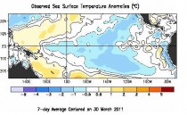
The cold water in the eastern Pacific has become patchy. Some of the ENSO models have been predicting the bounce back to El Nino. The NASA GMAO model was the most aggressive in this regard taking it to a borderline strong El Nino.
Enlarged
This weakening happened in 2008 after the La Nina winter of 2007/08 we actually warmed above normal even to the central Pacific briefly before cooling resumed. We covered this is some detail in this recent post.
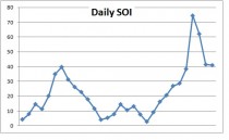
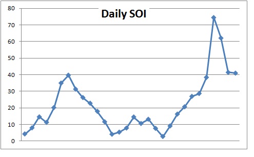
The Southern Oscillation Index (SOI) if El Nino was coming on would be strongly leading the charge by dropping into negative territory. You can see how positive it has been in the last year.
See how it 2008 it dipped in July to a slight negative before rebounding into the second La Nina winter before El Nino conditions kicked in by the summer of 2009.
The last 30 days the SOI has been dramatically positive, just three days ago spiking to more than 7.5 STD positive (La Nina). This will enhance the easterlies in the tropical zone.
Indeed the new CFS ensemble model (version 2) has in many of the latest forecast models shown a dramatic late year cooling after the rebound into the early summer.
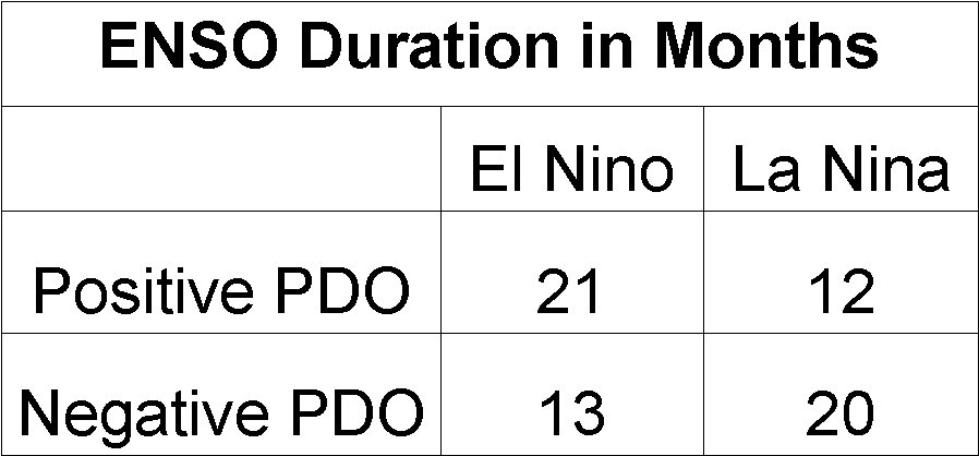
This fits better the ENSO pattern in the cold (negative) PDO - we tend to get more La Ninas and they tend to last longer than the El Ninos, the opposite of the warm PDOs.

See post and others on WeatherBell.
Note: Hansen and the warmers think of El Ninos as their friend and La Ninas as a temporary nuisance that stops the warming. The difference between El Nino peaks and La Nina troughs have been in the 13 month running average about 0.5C (0.9F). Clearly one of the reasons we saw warming between 1979 and 1998 was we had 3 times as many El Ninos which lasted twice as long as La Ninas. That is why you will never hear a warmist speak about PDO though they will (have to) use La Ninas as an excuse for when it cools.