


Joseph DAleo, CCM
Link
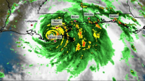
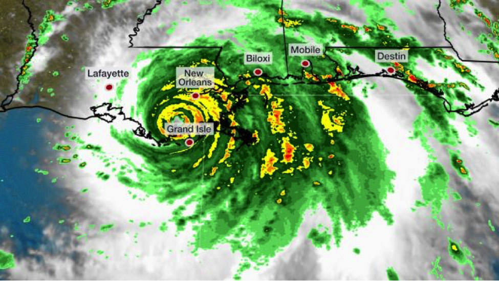
Ida came ashore in Louisiana as a strong CAT4 hurricane.
Enlarged
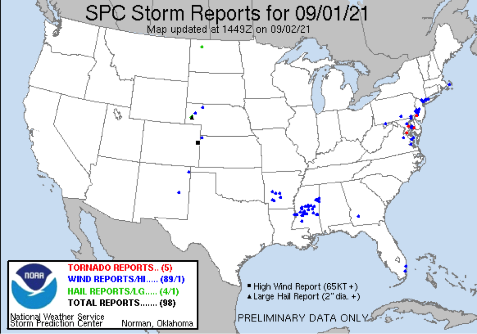
It produced major flooding and wind damage and widespread lengthy power outages in Louisiana where at least 6 died. Ida then turned northeast and then east. After coming ashore and moved north it triggered 3 tornadoes in Alabama and 1 in Virginia. On the way out to sea, the storm spun up 8 more tornadoes in PA and NJ to MD late Wednesday as many hurricane landfalls often do. Beulah in 1967 produced 115 tornadoes over a large area, ranging from the Texas coastal communities to South Central and Southeast Texas.
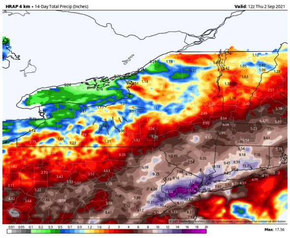
The storm brought torrential rains to the northeast centered on areas from southeastern Pennsylvania across northern New Jersey, the New York City Metro areas into southern Connecticut. Coming just days after record rains from Henri, 7 to 10 inches fell in a short period, producing catastrophic urban flooding.
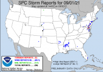
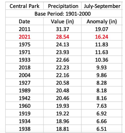
7.13 inches fell in Central Park (including 3.1 inches within one hour which shattered the record set only last week, when 1.94 inches of rain fell in one hour during Tropical Storm Henri). The National Weather Service issued a flash flood emergency in New York City for the first time ever and at least 9 fatalities have been recorded in the northeast. Most of these fatalities resulted from people caught in illegal basement apartments that flooded. More fatalities may have occurred as Ida exited than where and when it came ashore.
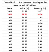
This moved 2021 into second place behind only 2011 (Irene) for July to September rainfall with a total of 28.54 inches...with 4 weeks to go.
Enlarged
More fatalities may have occurred as Ida exited than where and when it came ashore. Coming after a record wet July in places and a wet August with the help of Henri, the soil moisture contributed to the rainfall.
Enlarged
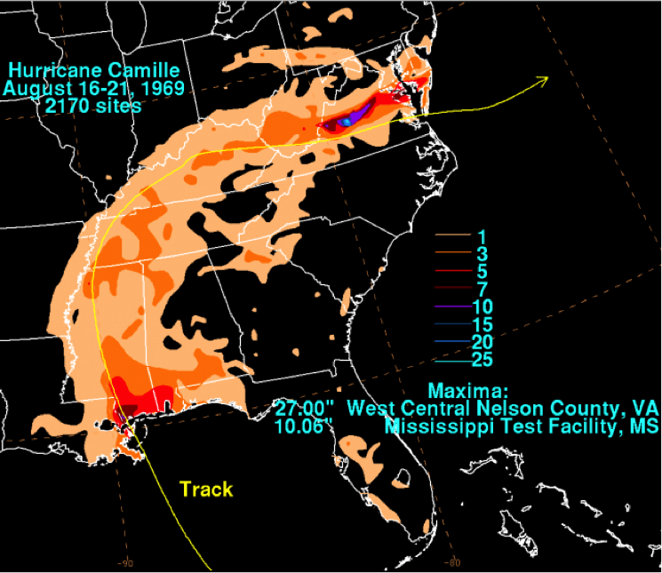
CAMILLE 1969
In August 1969, Camille, a CAT5 storm came ashore a little further east In MS and had a one-two punch. Camille was the second of three Category 5 hurricanes to make landfall during the 20th Century, which it did near the mouth of the Mississippi on the night of August 19th, resulting in catastrophic damage. Camille made landfall with a pressure of 900 mb, estimated sustained winds of 200 mph, and a peak storm surge of 24 feet.
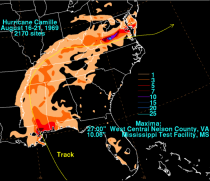
Enlarged
Camille was the strongest landfalling tropical cyclone recorded worldwide, and one of only four tropical cyclones worldwide ever to achieve wind speeds of 190 mph. The hurricane flattened nearly everything along the coast of the Mississippi, and caused additional flooding and deaths inland before exiting in Virginia. In total, Camille killed 259 people and caused $1.42 billion (1969 USD) in damages.
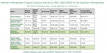
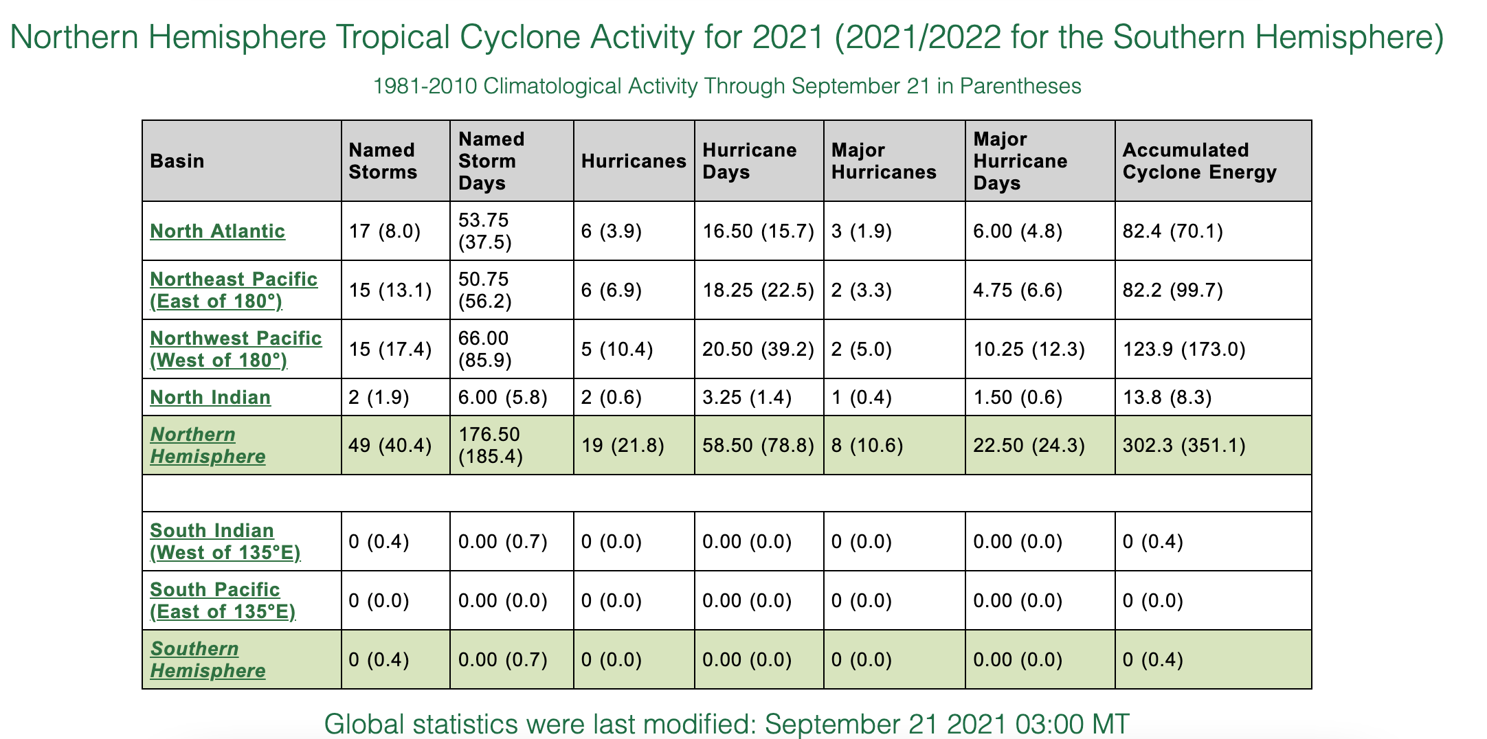
Is 2021 going to be a record year for hurricanes? No, in fact, despite an active Atlantic in 2020 for storms and Ida this season, for the hemisphere, we are for the second year is a row, well below the normal.
The ACE (Accumulated Cyclone Energy) Index is a metric used to assess seasonal and regional trends. Though we are running above normal for the number of named storms in the Atlantic, the east Pacific is near normal and the western Pacific, usually the busiest tropical season region is running half the normal pace. 2020 was similar with a record number of Atlantic storms but the average ACE per storms was reportedly the lowest on record again with a quiet Pacific.
Enlarged
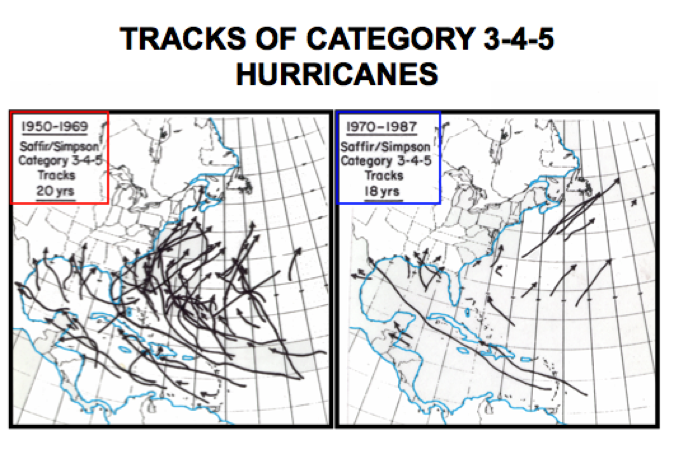
The long-term linear trend in the number and intensity of global hurricane activity has remained flat or even declined.
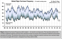
The late, great Dr. Bill Gray from Colorado State taught us hurricane activity does vary year-to-year and over longer periods as short-term ocean cycles like El Nino/La Nina and multi-decadal cycles in the Pacific (PDO) and Atlantic (AMO) ocean temperature regimes which favored changes in activity levels and some basins (West Pacific, East/Central Pacific or Atlantic) over others.
Credible data show this trend pattern is true despite much better open ocean detection than before the 1960s when many short-lived storms at sea would have been missed as there were no satellites, no aircraft reconnaissance, no radar, no buoys and no automated weather stations back then. See NOAA June Study here.
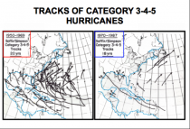
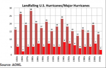
Landfall counts are more reliable. This data actually shows that the number of U.S. landfalling hurricanes and major hurricanes has been on the decline since the late 1800s. This past decade was the quietest one for landfalling hurricanes (behind the 1970s) and major hurricanes (behind only the 1860s).
However, the impacts on the United States has varied considerably with time, with very active seasons giving way to long lulls during which the public forgets the lessons from past storms and the risks of settling in vulnerable areas. The regions targeted vary too.
Great Colonial hurricanes in the northeast with storm surges up to 20 feet occurred in 1635 and 1675. A Katrina like storm made landfall in Louisiana in 1722 with major flooding and damage in Louisiana. The Great Chesapeake storm in 1769 like Isabel in 2003 brought major flooding to North Carolina and Virginia.
In the Caribbean, the Great Hurricane of 1780 killed an estimated 27,500 people while ravaging the islands of the eastern Caribbean with winds estimated to top 200 mph. It was one of three hurricanes that year with death tolls greater than 1000.
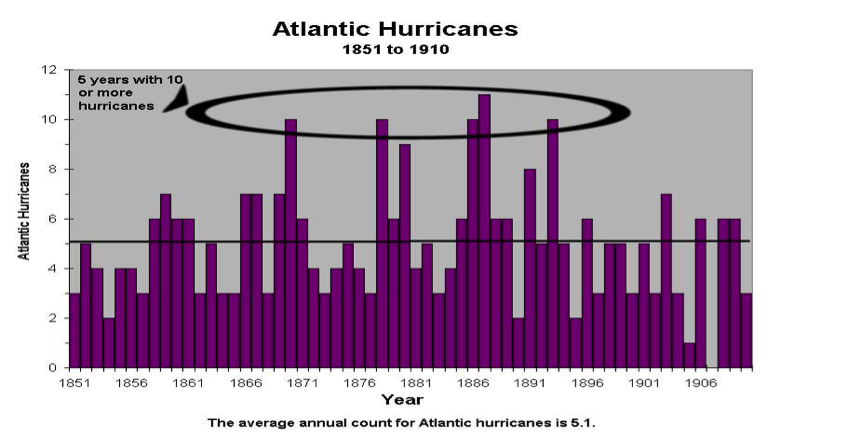
The period from the 1850s to 1910 was very active in the Gulf area.
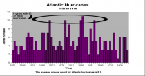
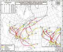
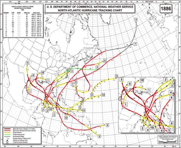
1886 had least 10 hurricanes, 7 making landfall (3 in Texas). 4 of the 1886 hurricanes were major hurricanes.
Dr. Neil Frank, longest serving Hurricane Center Director adds:
“Without question the most reliable indicator of a trend in hurricane activity in the Atlantic is to focus on land falling major hurricanes (3-5) in the mainline U.S. I doubt if a major hurricane could have hit the U.S. in the 1800s without being noticed, while a minor hurricane in a remote area could have been undetected so it is important to concentrate on major hurricanes. It is important to emphasize that the rainfall in a tropical system is not related to the intensity but depends on the forward speed of motion. In the case of Harvey, the weakening hurricane stalled over southeast Texas for three days.
Finally, as you know the most active hurricane season in the U.S. was 1886 when 7 hurricanes hit the Gulf coast. One of the major hurricanes in Texas destroyed Indianola on the south shore of Matagorda Bay. At one time there were around 20,000 people in the city before a prior major hurricane in 1875 did major damage. The only thing in Indianola today is a cemetery with numerous headstones with dates 1875 or 1886.”
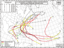
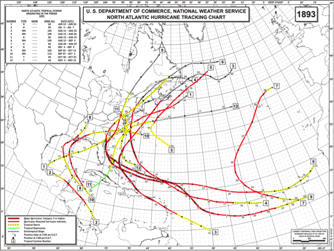
1893 had at least 10 hurricanes. Of those, 5 became major hurricanes. Two of the hurricanes caused over two thousand (2000) deaths in the United States; at the time, the season was the deadliest in U.S. history.
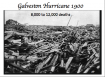
The Galveston Hurricane in 1900 killed at least 8,000 people with some estimates as high as 12,000, making it the deadliest natural disaster in U.S. history.Just 7 years later, the Galveston Hurricane in 1900 killed at least 8,000 people with some estimates as high as 12,000, making it the deadliest natural disaster in U.S. history. Most of these deaths occurred after a storm surge inundated the coastline with 8 to 12 feet of water. Every building and dwelling suffered some degree of damage and 3,636 homes were demolished.
The disaster ended the Golden Era of Galveston, as the hurricane alarmed potential investors, who turned to Houston instead. In response to the storm, three engineers designed and oversaw plans to raise the Gulf of Mexico shoreline of Galveston Island by 17 feet and erect a 10 mile seawall.
Though the Gulf and Caribbean waters are always warm enough to trigger storms every year, the areas further north do see quieter periods. After decades of no impact storms, there were 8 major devastating storms on the east coast from 1938 to 1960 then a 28-year lull until Hugo in 1989 began another active era of increased activity. We will soon as the earth goes into the next cool period driven by the sun and sun’s impacts on the ocean temperature regimes, see another relative quiet period further north.
Already the tropical atmosphere is showing no warming.
_thumb.png)
Enlarged
And the most skillful statistical model that with high accuracy explained the temperature changes (short term and long) since 1979 using solar and ocean factors, suggested in 2016 a cooling that would show up about now.
_thumb.png)
And more evidence about the arctic, fires, hurricanes and tornadoes.
 \
\
Enlarged
_thumb.png)
_thumb.png)
_thumb.png)
.png)
.png)
.png)
.png)
.png)