


Iowa National Guard troops have dumped thousand-pound sandbags from a helicopter to delay a full breach of a Missouri River levee long enough to build a secondary wall to protect a town, officials said on Monday.
The U.S. Army Corps of Engineers warned that the partial break of the levee near the Iowa and Missouri border could not be repaired and local emergency management officials have ordered a mandatory evacuation of the town of Hamburg, Iowa.
“What we have had is the Iowa National Guard come in and drop thousands of pounds of sandbags to help fill that breach, but that is just going to delay the full breach,” Corps spokeswoman Monique Farmer said on Monday.
It will take about a week to raise a secondary flood protection for Hamburg by five feet to reduce the risk to the town, Farmer said.
The National Guard dropped 22 sandbags weighing a thousand pounds each on the levee Sunday to patch the breach about 5-1/2 miles south of Hamburg, said John Benson, a spokesman for the Iowa Homeland Security and Emergency Management division.
The Corps plans an arc-shaped barrier to protect Hamburg’s south side and several hundred residents have been ordered to evacuate from that area, Benson said.
The evacuation covers about one-quarter of the town’s roughly 1,200 residents. A small fracture, a “sand boil,” discovered Sunday on another levee has been repaired, Farmer said.
More levee breaches on the lower Missouri River downstream from the last reservoir in South Dakota are “definitely likely,” said Kevin Grode, a reservoir regulation team leader for the Corps’ Missouri Basin office.
Nearly a year’s worth of rain fell on the Upper Missouri basin in the past few weeks, coupling with a heavy melting snow pack to swell reservoirs from Montana through South Dakota to their limits, forcing the Corps to release record flows to relieve the pressure.
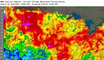
Enlarged 30 day rainfall.
Lynn Maximuk, central region director for the National Weather Service, said the rain and heavy snows were typical of a La Nina year weather pattern.
THOUSANDS EVACUATE
Thousands of residents have voluntarily evacuated the North Dakota capital Bismarck and nearby Mandan and the South Dakota capital Pierre and nearby Fort Pierre as well as the affluent Dakota Dunes near the Iowa border as the river threatens to overwhelm flood protections.
Levees in North Dakota and South Dakota were holding on Monday. South Dakota Governor Dennis Daugaard reported more progress on levees in flood-threatened towns as workers fought through temperatures into the 90s amid humid conditions.
The Corps plans to step up water releases to a maximum 150,000 cubic feet per second at the Oahe Dam above Pierre on Tuesday and at other reservoirs by mid June. Flows could stay at those levels at least into mid August.
“It is possible that we could go higher than that ... if we get higher than normal precipitation throughout June and July,” Grode said.
Iowa emergency officials are watching for maximum flows planned at the Gavins Point reservoir above Dakota Dunes on June 14 because it is the final control over river levels that will affect the levees near Hamburg.
Iowa is bracing for the Missouri to spill up to two miles into the state during the flooding and Fremont County has set up an emergency shelter in nearby Sidney for Hamburg residents who might need it. No one used the shelter overnight.
Iowa Governor Terry Branstad said on Monday he believed the flooding would be the worst he’s ever seen and that low-lying areas of Interstate 29 that runs parallel to the river likely would eventually be closed.
The U.S. Coast Guard has closed a more than 180-mile (290-kilometer) stretch of the river from near Sioux City, Iowa, south due to high water.
The river is projected to reach up to seven feet above flood stage at Sioux City, Omaha and Kansas City when the maximum release rate is reached.
The Missouri River basin forms the northwest portion of the massive Mississippi River basin that stretches from Montana to western New York and funnels water down through Louisiana into the Gulf of Mexico.
(By Kay Henderson. Additional reporting by David Bailey in Minneapolis; Editing by Greg McCune)