


NASA Mission Seas
Icecap Note: You will note the Hansen influence on this story. Instead of just reporting the facts, they have to repeat the talking points of the alarmist agenda. We support NASA’s and NOAA’s technology attempts and the work of Willis et al. We hope the data from the new satellites is not subject to the so called “quality assurance” adjustments GISS and NCDC are so famous for with their outlier GISS/GHCN data bases. Let the data speak for itself.
Global sea level has risen 20 centimeters (eight inches) in the past 100 years, and the rate of rise is predicted to accelerate as Earth warms. Melting ice from Greenland and Antarctica could raise sea level more than one meter (three feet) over the next century. One obvious threat is inundation, or loss of land to rising water. Other consequences are more complex, but equally problematic--a warmer ocean can fuel more intense storms; environmental changes can adversely affect ocean life, such as coral reefs and fisheries; and alterations in ocean currents can trigger radical changes in Earth’s climate.
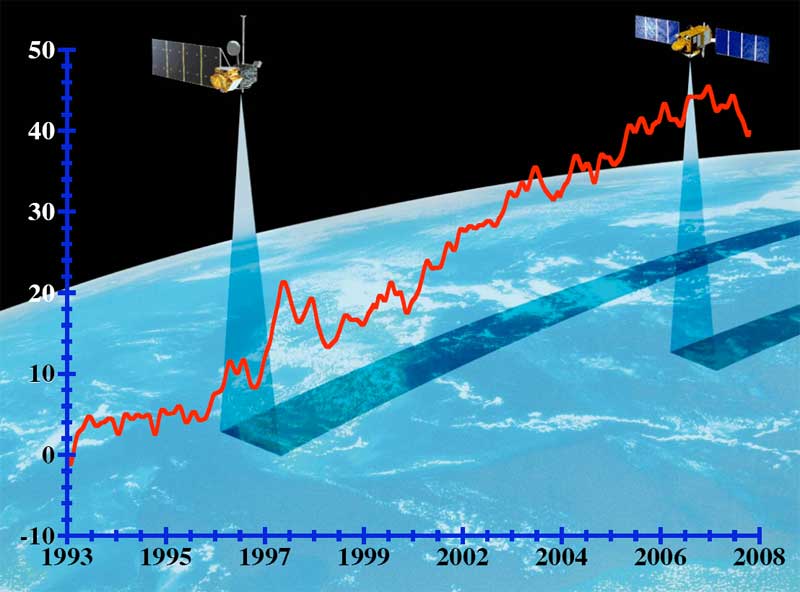
The best hope for anticipating the future is to understand the past and present. For global sea level, the first step has been to measure it accurately, a challenge in itself. Records of global sea level in the past come from averaging tide gauge readings from many locations. But since the launch of Topex/Poseidon in 1992, followed by Jason-1 in 2001, scientists have had a precise measurement of the height of the global ocean every 10 days. Now the Ocean Surface Topography Mission/Jason-2, scheduled to launch June 20 from California’s Vandenberg Air Force Base, will continue this critical task.
For a closer look at ocean heat, scientists turn to temperature and other measurements made by the thousands of Argo floats. “The Argo profilers give us a good representation of the upper 1,000 meters (3,281 feet) of the ocean,” Chambers said. “And since altimeters and Grace measure the total ocean, using what we know about the upper ocean from Argo gives us an idea about what’s going on below in the deep ocean, about which we have little data.”
“We know the basics of sea level rise very well,” said JPL oceanographer and climate scientist Josh Willis. But several critical elements still need to be resolved, he stressed. “Everything doesn’t quite add up yet.” For example, in a recent study, Willis, Chambers and their colleague Steven Nerem of the Colorado Center for Astrodynamics Research in Boulder, compared the amount of ocean warming during 2003 to 2007 observed by the Argo buoys with the amount of warming calculated by combining Grace and Jason-1 altimeter data. While the two measurements closely matched with regard to seasonal ups and downs, they didn’t agree at all on the total amount of warming. In fact, the Argo data showed no warming at all, while the combined Jason and Grace data did.
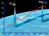
See NASA graph. Notice downturn in last year. See larger image here
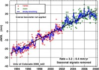
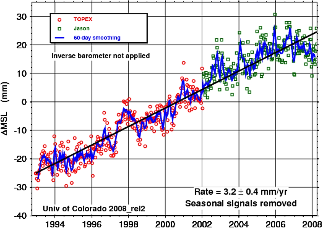
See larger image here
Again this may be the result of the ocean cooling the last year from the flip of the PDO and La Nina which causes compression and/or growth of the Antarctic and maybe even Greenland ice sheets.