


By Anthony Watts
Paging Joe Romm:
“In fact, this record-breaking snowstorm is pretty much precisely what climate science predicts. Since one typically can’t make a direct association between any individual weather event and global warming, perhaps the best approach is to borrow and modify a term from the scientific literature and call this a “global-warming-type” deluge.”
From Columbia Earth Institute, home to NASA GISS:
“This paper explains what happened, and why global warming was not really involved. It helps build credibility in climate science.”
See PR below and a link to the full paper follows. Hemisphere winter snow anomalies: ENSO, NAO and the winter of 2009/10, Geophys. Res. Lett., 37, L14703, doi:10.1029/2010GL043830.
Via Eurekalert: Converging weather patterns caused last winter’s huge snows
Last winter was the snowiest on record for Washington, D.C., and several other East Coast cities. Image via Eurekalert Credit: FamousDC.com
The memory of last winters blizzards may be fading in this summer’s searing heat, but scientists studying them have detected a perfect storm of converging weather patterns that had little relation to climate change. The extraordinarily cold, snowy weather that hit parts of the U.S. East Coast and Europe was the result of a collision of two periodic weather patterns in the Atlantic and Pacific Oceans, a new study in the journal Geophysical Research Letters finds.
It was the snowiest winter on record for Washington D.C., Baltimore and Philadelphia, where more than six feet of snow fell over each. After a blizzard shut down the nation’s capital, skeptics of global warming used the frozen landscape to suggest that manmade climate change did not exist, with the family of conservative senator James Inhofe posing next to an igloo labeled “Al Gore’s new home.”
After analyzing 60 years of snowfall measurements, a team of scientists at Columbia University’s Lamont-Doherty Earth Observatory found that the anomalous winter was caused by two colliding weather events. El Nino, the cyclic warming of the tropical Pacific, brought wet weather to the southeastern U.S. at the same time that a strong negative phase in a pressure cycle called the North Atlantic Oscillation pushed frigid air from the arctic down the East Coast and across northwest Europe. End result: more snow.
Using a different dataset, climate scientists at the National Oceanic and Atmospheric Administration came to a similar conclusion in a report released in March.
“Snowy winters will happen regardless of climate change,” said Richard Seager, a climate scientist at Lamont-Doherty and lead author of the study. “A negative North Atlantic Oscillation this particular winter made the air colder over the eastern U.S., causing more precipitation to fall as snow. El Nino brought even more precipitation - which also fell as snow.”
In spite of last winter’s snow, the decade 2000-2009 was the warmest on record, with 2009 tying a cluster of other recent years as the second warmest single year. Earth’s climate has warmed 0.8C (1.5F) on average since modern record keeping began, and this past June was the warmest ever recorded. Icecap Note: necesdsary disclaimer. Not true of course since the global data base is seriously contamination (50%+ warm bias) especially since 1990.
While the heavy snow on the East Coast and northwest Europe dominated headlines this winter, the Great Lakes and western Canada actually saw less snow than usual - typical for an El Nino year, said Seager. Warm and dry weather in the Pacific Northwest forced the organizers of the 2010 Winter Olympic Games in Vancouver to lug in snow by truck and helicopter to use on ski and snowboarding slopes. The arctic also saw warmer weather than usual, but fewer journalists were there to take notes.
“If Fox News had been based in Greenland they might have had a different story,” said Seager.
While El Nino can now be predicted months in advance by monitoring slowly evolving conditions in the tropical Pacific Ocean, the North Atlantic Oscillation - the difference in air pressure between the Icelandic and Azores regions - is a mostly atmospheric phenomenon, very chaotic and difficult to anticipate, said Yochanan Kushnir, a climate scientist at Lamont-Doherty and co-author of the study.
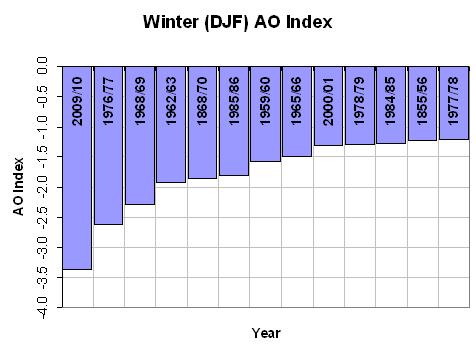
The last time the North Atlantic experienced a strong negative phase, in the winter of 1995-1996, the East Coast was also hammered with above average snowfall. This winter, the North Atlantic Oscillation was even more negativea state that happens less than 1 percent of the time, said Kushnir.
“The events of last winter remind us that the North Atlantic Oscillation, known mostly for its impact on European and Mediterranean winters, is also playing a potent role in its backyard in North America,” he said.
David Robinson, a climate scientist at Rutgers University who was not involved in the research, said the study fills an important role in educating the public about the difference between freak weather events and human-induced climate change.
“When the public experiences abnormal weather, they want to know what’s causing it,” he said. “This paper explains what happened, and why global warming was not really involved. It helps build credibility in climate science.
-----------
Heres the full paper (PDF, thanks to Leif Svalgaard)
Abstract:
Winter 2009/10 had anomalously large snowfall in the central parts of the United States and in northwestern Europe. Connections between seasonal snow anomalies and the large scale atmospheric circulation are explored. An El Nino state is associated with positive snowfall anomalies in the southern and central United States and along the eastern seaboard and negative anomalies to the north. A negative NAO causes positive snow anomalies across eastern North America and in northern Europe. It is argued that increased snowfall in the southern U.S. is contributed to by a southward displaced storm track but further north, in the eastern U.S. and northern Europe, positive snow anomalies arise from the cold temperature anomalies of a negative NAO. These relations are used with observed values of NINO3 and the NAO to conclude that the negative NAO and El Nino event were responsible for the northern hemisphere snow anomalies of winter 2009/10.
Citation: Seager, R., Y. Kushnir, J. Nakamura, M. Ting, and N. Naik (2010), Northern Hemisphere winter snow anomalies: ENSO, NAO and the winter of 2009/10, Geophys. Res. Lett., 37, L14703, doi:10.1029/2010GL043830.
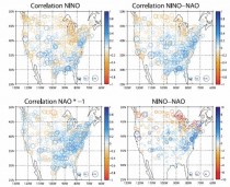
Figure 1. The correlation of snowfall with (top left) the NINO3 index, (bottom left) the NAO index and (top right) the standardized NINO3 minus standardized NAO (NINO-NAO) index and (bottom right) the regression of snowfall on the NINO-NAO index. All indices and the snowfall are for the winter (December to March) mean. Units for the regression are inches. -click here to enlarge
Conclusions
[11] In winters when an El Nino event and a negative NAO combine, analyses reveal that there are positive snow anomalies across the southern U.S. and northern Europe. In western North America and the southeast U.S. snow anomalies are associated with total precipitation anomalies and southward shifts in the storm track. In the eastern U.S., north of the Southeast, and in northwest Europe positive snow anomalies are associated with the cold temperature anomalies accompanying a negative NAO. The relations between large-scale climate indices and snow anomalies were used to attribute the snow anomalies for the 2009/10 winter with notable success in pattern and amplitude. We conclude that the anomalously high levels of snow in the mid‐Atlantic states of the U.S. and in northwest Europe this past winter were forced primarily by the negative NAO and to a lesser extent by the El Nino. The El Nino was predicted but, in the absence of a reliable seasonal timescale prediction of the NAO, the seasonal snow anomalies were not predicted. Until the NAO can be predicted (which may not be possible [Kushnir et al., 2006]), such snow anomalies as closed down Washington D.C. for a week will remain a seasonal surprise.
ICECAP Note: Recall we projected a negative AO/NAO due to low solar/east QBO favored stratospheric warming, a positive AMO and high latitude volcanoes (Redoubt and Sarychev). The AO was most negative since 1950.
Whereas it is not always possible, many years it is. Continued low solar and a positive AMO should bias the NAO to negative in upcoming winters. If Katla goes, watch out.