


HIGHLIGHTS
* New record storm surge for Battery
* Governor of NJ: “Damage to the Jersey coast is unprecedented.”
* Devastation to Long Island and southern New York City boroughs is widespread with 41 dead in the City alone
* Death toll has risen to at least 90
* Damage estimated now at least $50 billion dollars.
* Severe flooding and rescues continue in the NE part of New Jersey where levees were overtopped by the storm surge inundating three towns.
* 8.1 million people are now without power and estimated restoration times range from 7 days to over 3 weeks. Cold weather is coming
* 80 homes have burned in Queens, New York due to a fire started by arcing power line and then spread from house to house by strong winds.
* Helicopter views of the New Jersey coast reveal incredible damage. Barrier islands have been cut in half in some places with structures heavy damaged and large 20-25 foot protective dunes completely gone.
* 90% of Hoboken, NJ has been flooded with sea water.
* NJ transit system will be closed until further notice due to damage. Damage to NYC transit system is extensive.
* Seaside Heights Boardwalk (Famous from MTV’s Jersey Shore) is gone
* The Jersey Coast and southern Long Island has been devastated
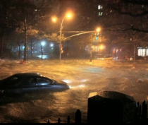
Lower East Side, Manhattan
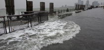
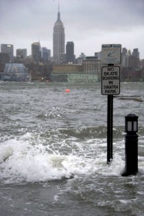
Water entering Battery Park where record tide level set in the evening
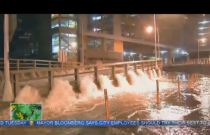
Water cascades like a waterfall into the Brooklyn Battery Tunnel
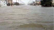
Flooding on the Connecticut shore
Hoboken New Jersey 13 foot surge
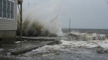
Beach Haven, Long Beach Island, NJ
Sandy came ashore in southern New Jersey, bringing 80-90-mph winds and a roiling wall of seawater as it moved inland and north toward New York City. It sent 90-mph gusts through the Wall Street canyons and water surging to a record 13 feet in Lower Manhattan, flooding the subway system and prompting Consolidated Edison to cut power to part of the area to avoid storm damage. Manhattan's FDR Drive was under water south of 20th Street. Water from West Street Cascaded like a "waterfall" into the Brooklyn Battery Tunnel. The Holland Tunnel was also said to be flooded. In a confirmation of the fears of Metropolitan Transportation Authority, subway tunnels and stations flooded Monday evening as water rushed through Battery Park and other areas.
The 13.88 foot storm surge at the Battery surpassed the old record of 11.2 feet in the great hurricsne of 1821. That 1821 hurricane's surge occurred at low tide. the surge in 2012 came at high tide and with a full moon. It has left behind flooded homes and businesses and 7 million without power. The New York City subway system “has never faced a disaster as devastating” as the damage that was caused by Superstorm Sandy, Metropolitan Transportation Authority chairman Joseph Lhota said Tuesday. Seven subway tunnels under the East River flooded Monday night as the MTA cut power to some subway stations Monday after water began pouring into the some of the stations and tracks.
Hurricane Sandy wreaked havoc on our entire transportation system, in every borough and county of the region,” Lhota said. Metro-North lost power from 59th Street to Croton-Harmon on the Hudson Line and to New Haven on the New Haven Line, Lhota said. The Long Island Rail Road had to evacuated its West Side Yards and suffered flooding in one East River tunnel. We’re seeing flooding pretty much throughout the entire area with most of the flooding we’re seeing in Lower Manhattan,” MTA spokesman Kevin Ortiz told CBS 2. The MTA has shut down power to the tunnels that run under the East River between Manhattan to Brooklyn. But flooding was still reported at several stations and tunnels. Ortiz said virtually all the stations and tunnels south of Chambers Street were flooded. In Queens, the Rockaway Park A station was also inundated, with water reaching the platform. Crews were working with portable pumps to get the water out as quickly as possible, but the flooding is not good news when it comes to reopening the subway system. It is really difficult to predict the amount of time to pump the water out from flooded tunnels and adjoining stations,” Ortiz said. MTA officials said previously that salt water could corrode the switches and signals in the system and could force the MTA to replace hundreds of pieces of equipment before service could be restored.
But even before the MTA gets to restoring the signals, it could be as few as 14 hours and as much as four days before all the water is even pumped out, Ortiz said. Gov. Andrew Cuomo and MTA officials have repeatedly emphasized that salt and the subway system don’t mix. We’re very concerned about the water surge in the Battery, where most of our lines go down and where the tunnels to Brooklyn go. That is one of our most low-lying areas, and we’ve boarded them up,” MTA Chairman Joe Lhota said before the floodwaters began rushing near Battery Park. “We’ve put up various different barriers to prevent the water from coming in. But that’s my biggest concern.
Officials said especially vulnerable subways lines are the A, F, 2, 3, 4, 5, N and R trains, which all run through tunnels connected to lower Manhattan. The switches are really important for controlling the flow of the subway system. They could corrode quite easily.
Storm surge and tide relative to mean low water reached a record 13.88 feet at the Battery. The previous record flood level was in the Hurricane of 1821. Flood levels are higher in Hoboken than the records also set in 1821. The full moon contributed about a foot or so to the tide records. The NY stock Exchange trading floor was reported by The Weather Channel to be under 3 feet of water. This report according the ABC TV in NYC was in error.
JFK reported a wind gust of 79mph this evening. Islip on Long Island had a gust to 90 mph earlier.
The 13.88 foot storm tide last evening just before 9 pm at the Battery was a new record, exceeding the level of 11.2 feet set in the Great Hurricane of 1821. The difference this time is that the surge came at high tide with a full moon while in 1821, amazingly the surge came at low tide.
The 1821 Hurricane was one of five known tropical cyclones that have made landfall in New York City Another, even more intense hurricane struck the region in pre-Columbian times (sometime between 1278 and 1438) and was detected by paleotempestological research.The third was the 1893 New York hurricane, the fourth was Hurricane Irene then Hurricane Sandy in 2012. Technically most of these storms touched land first elsewhere before battering the big apple.
Ironically the 1821 hurricane was the last of 5 such storms to target NYC from 1815 to 1821 during the Dalton solar minimum, a period not unlike the current period when Irene and Sandy hit in succesive years.

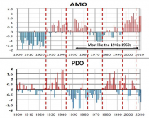
JB and I have warned that we were overdue for hurricane effects in the northeast since the AMO turned warm in 1995. A northeast hiot is more likely I had found when the PDO was also negative. This year both were the case. We are reliving the 1950s from the ocean standpoint buy the early 1800s or late 1800s and early 1900s from a solar. It is entirely possible given the AMO 70 year cycle that the early and late 1800s and early 1900 (1903) were +AMO and negative -PDO eras as well, making those decades even better analogs than the 1940s to early 1960s.
After two days of rain, a hurricane slammed into New York City on the afternoon of Monday, September 3, 1821. With the city completely unprepared for such a monstrous storm, the damage was enormous. The East and Hudson Rivers flooded over their banks, causing considerable flooding in lower Manhattan. And the hurricane force winds damaged structures throughout New York City, Brooklyn (which was still a separate city), Long Island, and New Jersey. The next day’s newspaper, the New York Evening Post of September 4, 1821, published a dramatic account of the storm, headlined “Tremendous Gale.”
The story described a storm lasting from 4:30 pm to 8:30 pm, striking with "all the violence and fury of a hurricane… throwing down chimneys, unroofing buildings, and prostrating trees in various directions."
When the gale was at its height it presented a most awful spectacle," the newspaper reported. "The falling of slate from the roofs of buildings, and broken glass from the windows, made it unsafe for any one to venture into the streets
The newspaper noted that the city had actually been fortunate, as the storm had arrived during low tide, it mentioned that the tide "rose to an unusual height, overflowing all the wharves and filling the cellars of all the stores on the margin of the East and North [Hudson] Rivers.
IT WAS THE STORM THAT CHANGED THE SCIENCE OF METEOROLOGY
A native of Connecticut, William C. Redfield grew up with a strong interest in science, and educated himself by borrowing books on scientific subjects. He was also known to be a prodigious walker, at times taking long treks from New England to visit relatives who had settled in Ohio. Following the great storm of 1821, Redfield walked through a large area of Connecticut which had been devastated by the high winds. He was intrigued to notice that in some areas the trees had been knocked down with their tops pointing to the northwest. In other areas, trees were arranged in the opposite direction, with their tops pointing to the southeast. The patterns of the battered trees convinced Redfield that hurricanes were complex circular storms, and he eventually published a paper on the topic in the American Journal of Science in 1832. Redfield's theory was that a hurricane was a great traveling whirlwind. Today we take that idea for granted, but at the time it was a new way of thinking about hurricanes. Prior to Redfield, the accepted belief was that the winds of hurricanes blew steadily from one direction.