


Weatherbell Analytics on Forbes
After a slow start to severe weather season, Monday’s devastating tornado that hit Oklahoma reminds us how costly and destructive the change of seasons can be in the United States. Following one of the coldest March/April stretches in several decades, which caught most of the energy market by surprise, April and the first half of May produced significantly fewer tornadoes than normal. The cold air that overwhelmed the country in March and April resulted in huge natural gas withdrawals, drove prices up some 30% and served as the mitigating factor for thunderstorm development.
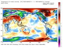
The March global temperature anomaly shows severe cold stretching from Alaska to Florida, as seen below.
As we progressed through May however, warm/moist air from the Gulf of Mexico has finally begun to surge north, creating boundaries between air masses with vastly different characteristics. More tornadoes occur in the U.S. than any other place on earth as a result of this classic setup.
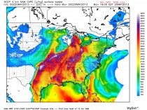
A deep low-pressure system centered over the Dakotas draped a strong cold-front through the plains pulling extremely moist and unstable air from the Gulf of Mexico.
CAPE (Convective Available Potential Energy), a metric of thunderstorm potential, saw extreme values ahead of the frontal boundary especially over Oklahoma during Monday’s tornado outbreak.
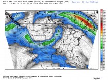
Another main ingredient for tornadogenesis was a strong upper-level jet streak from the southwest, which meant turning winds with height or vertical shear. So far during the spring, Gulf of Mexico moisture and favorable jet stream configurations were almost entirely absent, instead replaced with a cold, persistent northwesterly flow from snowcovered Canada.
The result was was explosive supercell thunderstorm development, as seen in the animation below.
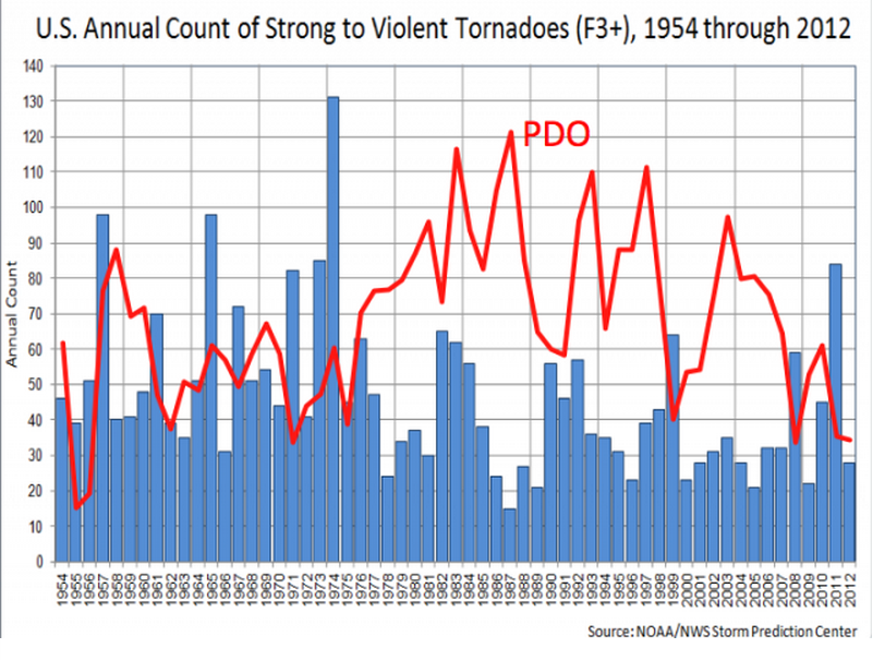
Damage from Monday’s severe weather outbreak is already being estimated to approach $2 billion. With more severe weather on the way, it is inevitable that we will see more damage and life-threatening situations. But on the heels of devastation like this week’s tornado, it is also important to remember that weather like this has always occurred and the current trend is similar to the climate cycle of the 1950s, with a cold Pacific and warm Atlantic. However, with an expanding population and greater suburban and rural development, more people and structures are in the path of deadly storms in the US than in the past.
It is critical to always be alert to the potential of severe weather. Businesses with enterprise alerting systems, which warn decision makers of certain weather events (ex. tornado watch or blizzard warning), can take action to protect physical assets and human life. Alerting systems can also be used by businesses to direct operations to limit financial hardship and in some cases, garner financial profit by avoiding shutdowns or outages.
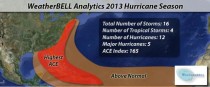
It doesn’t look like hurricane season is going to provide a respite from extreme weather. Joe Bastardi has warned for years that we would enter a period of climactic hardship as a result of the cold PDO (Pacific Decadal Oscillation) and warm AMO (Atlantic Multi-decadal Oscillation). Similar to the 1950s, the United States should experience heightened risk for landfalling hurricanes and higher likelihood of summer heat/drought. We have experienced tremendous heat and drought the last several years. Our summer forecasts calls for the heat to be less of an issue this year, as it should be centered over the Rockies and Texas. We expect a more normal temperature/precipitation profile for the Eastern half of the United States. However, tropical cyclone development should be above normal this year.
We expect an above normal ACE (Accumulated Cyclone Energy), a more meaningful measure of the total energy of tropical systems. The Atlantic sea surface temperature (SST) profile is similar to 2005, which was the most active Atlantic tropical season on record. The water temperatures in the deep tropics are substantially above normal, which should provide extra “fuel” for tropical cyclone development. With no sign of an El Nino, there will be little in the way of upper air shear to tear apart any storms that may form. And similar to the 1950′s, the overall climactic pattern should steer the storms towards the US coastline. Our official forecast can be seen in the chart below. This year’s activity will have far reaching impacts across the energy and insurance markets.
ICECAP NOTE: While the positive AMO (warm Atlantic) and negative PDO (cold Pacific) leads to enhanced Atlantic activty and landfall threat for the east, the cold Pacific (negative PDO) leads to more intense (E3-E5) tornadoes. Come join us at Weatherbell.com for more.
